Agricultural drought monitoring method

A technology of farmland and drought index, which is applied in the field of farmland drought monitoring, and can solve problems such as the lack of large-scale farmland drought monitoring methods

Inactive Publication Date: 2008-05-28
PEKING UNIV
View PDF0 Cites 46 Cited by
  • Summary
  • Abstract
  • Description
  • Claims
  • Application Information

AI Technical Summary

Problems solved by technology

Among these methods, there is no large-scale farmland drought monitoring method suitable for different growth stages of farmland crops

Method used


Image

  • Agricultural drought monitoring method
  • Agricultural drought monitoring method
  • Agricultural drought monitoring method

Examples


Embodiment 1

[0043] Embodiment 1, the construction of drought monitoring model

[0044] For different vegetation coverage, select the appropriate remote sensing band, and calculate the index suitable for characterizing the moisture status of the farmland under the vegetation coverage. The technical solution is as follows:

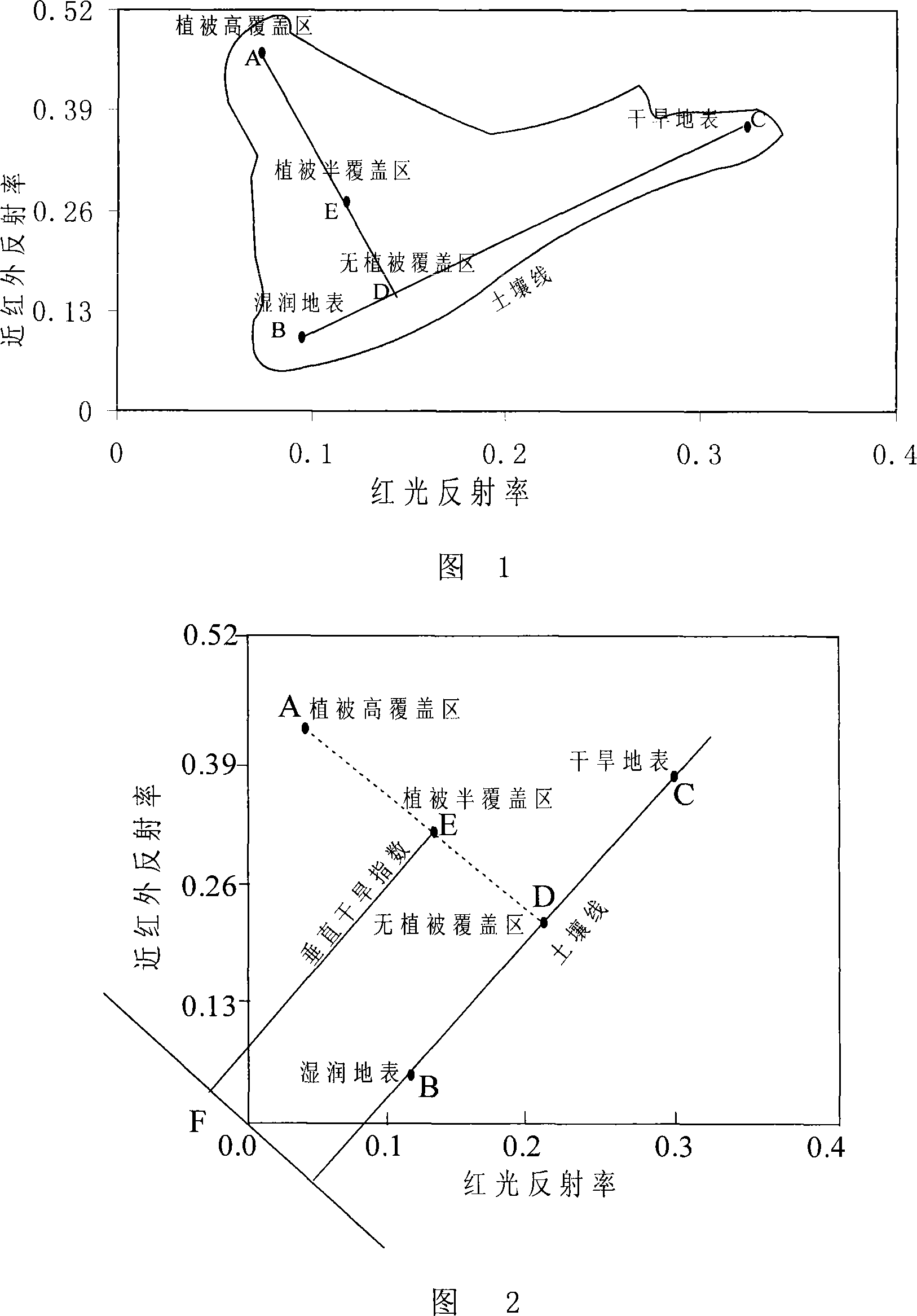
[0045] 1. For the surface with no vegetation coverage or low coverage (vegetation coverage ≤ 15%), the NIR-Red spectral feature space scatter diagram constructed using remote sensing related band data presents a typical triangular distribution (as shown in Figure 1), B-C is the soil baseline, and the soil gradually dries from B to C, and the mathematical expression of B-C as the soil baseline can be obtained through the spatial statistical characteristics:

[0046] R nir,s =MR red,s +I (1)

[0047] where R red,s , R nir,s are the reflectance of the red light band and the near-infrared band after atmospheric correction, M is the slope of the soil line, and I is the...

Embodiment 2

[0078] Embodiment 2, utilize the drought monitoring model of embodiment 1 to monitor farmland drought

[0079] 1. Take the area with a single soil type as a monitoring area.

[0080] 2. Select several points in the monitoring area to measure soil water content, field water capacity and wilting coefficient. It can be considered that the field water capacity and wilting coefficient in a single soil type area are consistent, so the two measured values ​​at each measuring point can be averaged to obtain the field water capacity and wilting coefficient of the entire monitoring area.

[0081] 3. According to the vegetation coverage of the monitoring area, select the appropriate band to calculate the drought monitoring index:

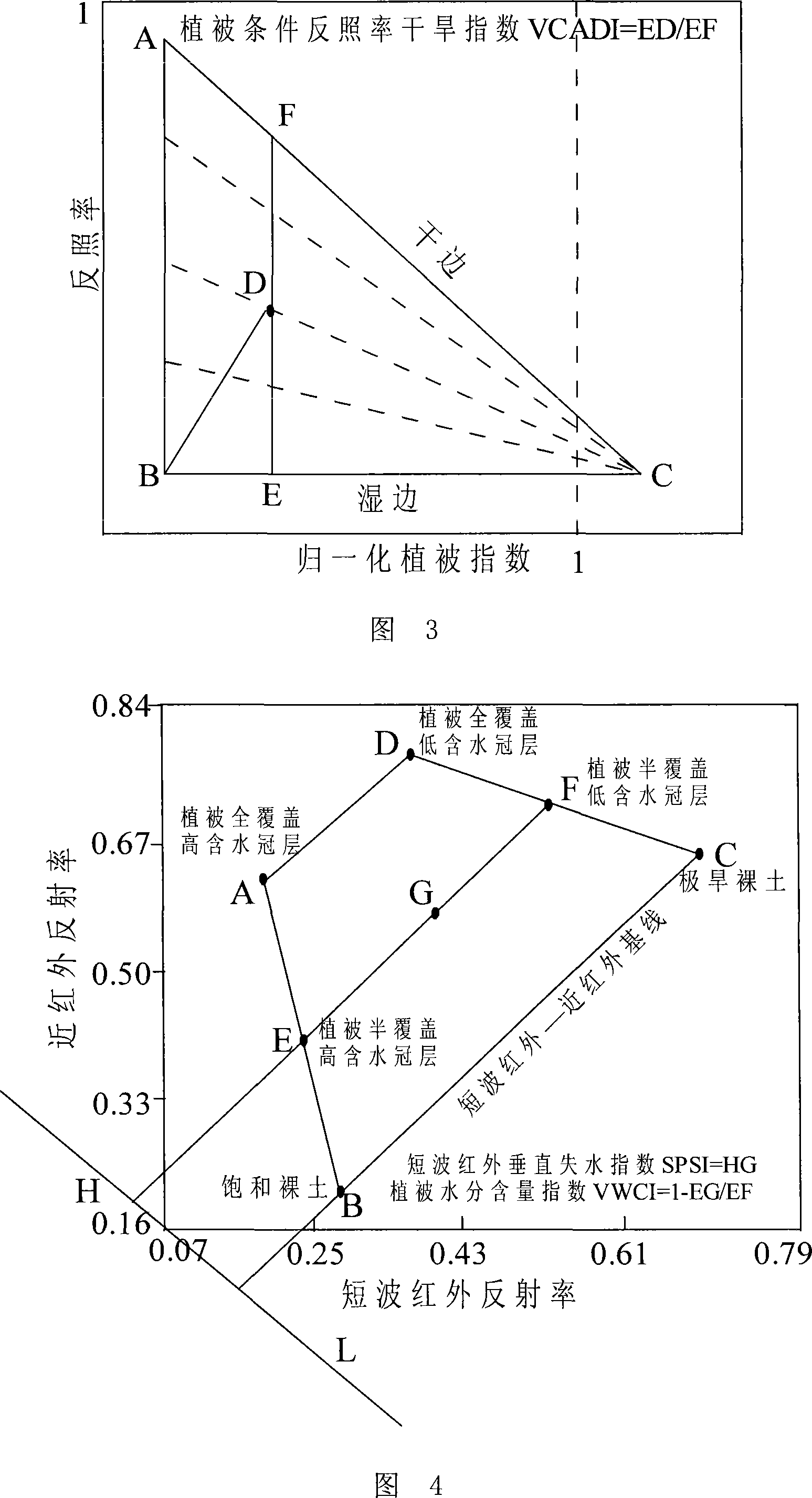
[0082] Perform PDI calculations using red and near-infrared bands.

[0083] Using albedo and normalized difference vegetation index data, the calculation of VCADI is carried out.

[0084] Use NIR and SWIR bands for SPSI, VCWI, VCSI calculations.

[0085] 4...


PUM


Abstract

The invention discloses a method for monitoring farmland drought, which comprises obtaining soil or leaf water content of an observing point which is arranged on monitoring ground surface, building a functional relation between soil or leaf water content of the observing point and a corresponding index of characterized farmland drought condition, taking remote sensing data into the functional relation, and obtaining the soil or leaf water content of the monitoring ground surface, wherein the corresponding index of characterized ground surface drought condition is defined according to following methods: Firstly, the farmland ground surface whose vegetation coverage< =15% adopts a vertical drought index, secondly, the farmland ground surface whose vegetation coverage>15% and <= 65% adopts a vegetation conditions albedo drought index, and thirdly, the farmland ground surface whose vegetation coverage>65% to 100% adopts at least one of three following indexes: a short wave infrared vertical water loss index, a vegetation water content index, and a vegetation water deficit index. The ground surface drought monitoring method of the invention is applied for drought testing farmland ground surface with different vegetation coverage degrees.

Description

technical field [0001] The invention relates to a farmland drought monitoring method. Background technique [0002] The occurrence process of drought is potential and not easy to discover; the occurrence of drought in farmland is characterized by a large area of ​​influence, which brings serious catastrophic consequences and economic losses; drought involves many factors, such as meteorological parameters, surface water conditions, human socio-economic conditions, etc. Activities and levels of agricultural production and production structure, etc. Remote sensing technology can provide multi-source, multi-dimensional and multi-temporal information of farmland, which opens up a new way for farmland drought monitoring. [0003] The traditional farmland drought monitoring is to monitor the degree and scope of the drought with the data on the observation point, and the meteorological observation data is the most widely used. Due to the periodic and regional characteristics of d...

Claims


Application Information

Patent Timeline
Patent Type & Authority Applications(China)
IPC IPC(8): G01N21/55G01N21/17G01S17/89G01V8/10G06F17/10G01N21/3563G01N21/359
Inventor 秦其明阿布都瓦斯提-吾拉木詹志明
Owner PEKING UNIV
Why Eureka
Try Eureka