Method for detecting and regulating sea survey line net systematical error

A system error and adjustment method technology, which is applied in surveying, mapping and navigation, measuring devices, open-air water source surveying, etc., can solve the problems that the calculation method has not yet been resolved, it is difficult to meet the application requirements of high-precision marine space information, and the efficiency is low.

Inactive Publication Date: 2008-07-30
刘雁春 +1
View PDF0 Cites 17 Cited by
  • Summary
  • Abstract
  • Description
  • Claims
  • Application Information

AI Technical Summary

Problems solved by technology

[0003] (2) Although some people have used the intersection point to determine the line system error in marine gravity measurement and marine magnetic measurement (two-step processing method of marine gravity measurement error compensation [J]. Journal of Wuhan University. Information Science Edition, 2002, 19(3 ): 251-255), but its calculation method has not yet been attributed to the rank deficient network adjustment theoretical height of the marine survey line network to deal with the marine gravity (or magnetic force) measurement problem
At this time, according to the common sense of surveying, an important scientific question arises: Can and how to use the closure error information of the intersection point to improve the accuracy of the survey line and the entire survey line network like land survey? The solution to this problem leads to the following questions: (1) What is the composition structure of the intersection closure error information? How to decompose and correct? (2) How to carry out survey line adjustment and survey line network adjustment to improve the accuracy of the whole ocean survey data? In fact, this is a problem that has puzzled hydrographic experts internationally for many years without satisfactory results
However, if this problem is not solved, a large amount of manpower and material resources can only be invested in re-measurement for the intersection points of the measuring lines with errors, which is not only costly, but also inefficient.
[0005] To sum up, at present, high requirements are put forward for the accuracy and reliability of oceanographic measurement results. When the measurement unit conducts bathymetry, it only simply and roughly judges whether it exceeds the limit and whether it needs to be remeasured based on the difference data of the intersection points. Using scientific and reasonable data processing methods, especially the lack of a set of theories and methods to solve how to determine the systematic errors and eliminate gross errors in bathymetry data and how to ensure and improve the accuracy and reliability of bathymetry, it is difficult to meet the requirements of obtaining high-precision ocean space information application requirements

Method used


Image

  • Method for detecting and regulating sea survey line net systematical error
  • Method for detecting and regulating sea survey line net systematical error
  • Method for detecting and regulating sea survey line net systematical error

Examples


Embodiment Construction

[0040] The present invention will be described in detail below in conjunction with specific examples, but is not limited to the specific examples.

[0041] Example of ocean bathymetry

[0042] On July 1, 2007, a grid test was carried out in a sea area in the North Sea of ​​China using conventional survey methods.

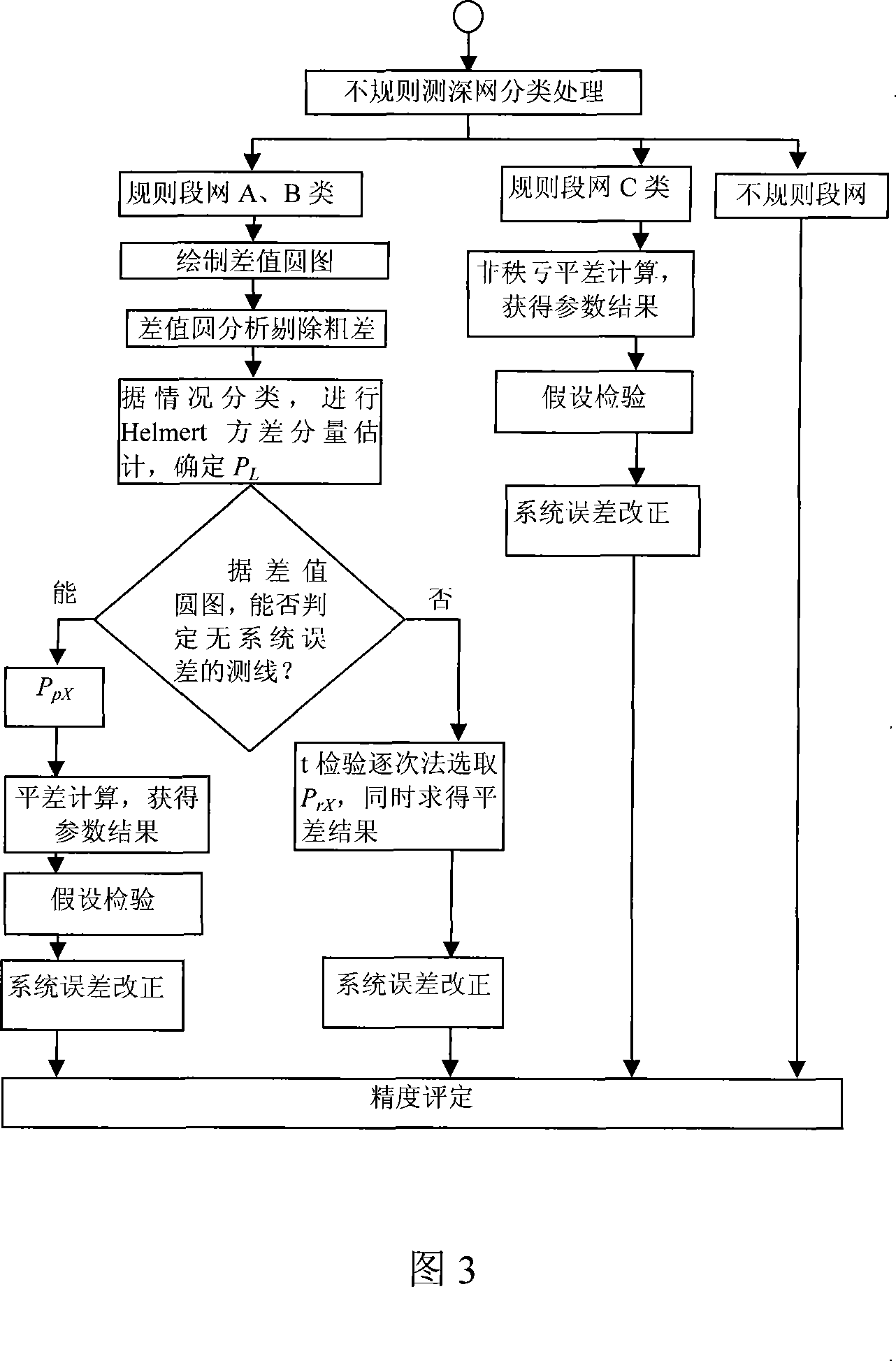
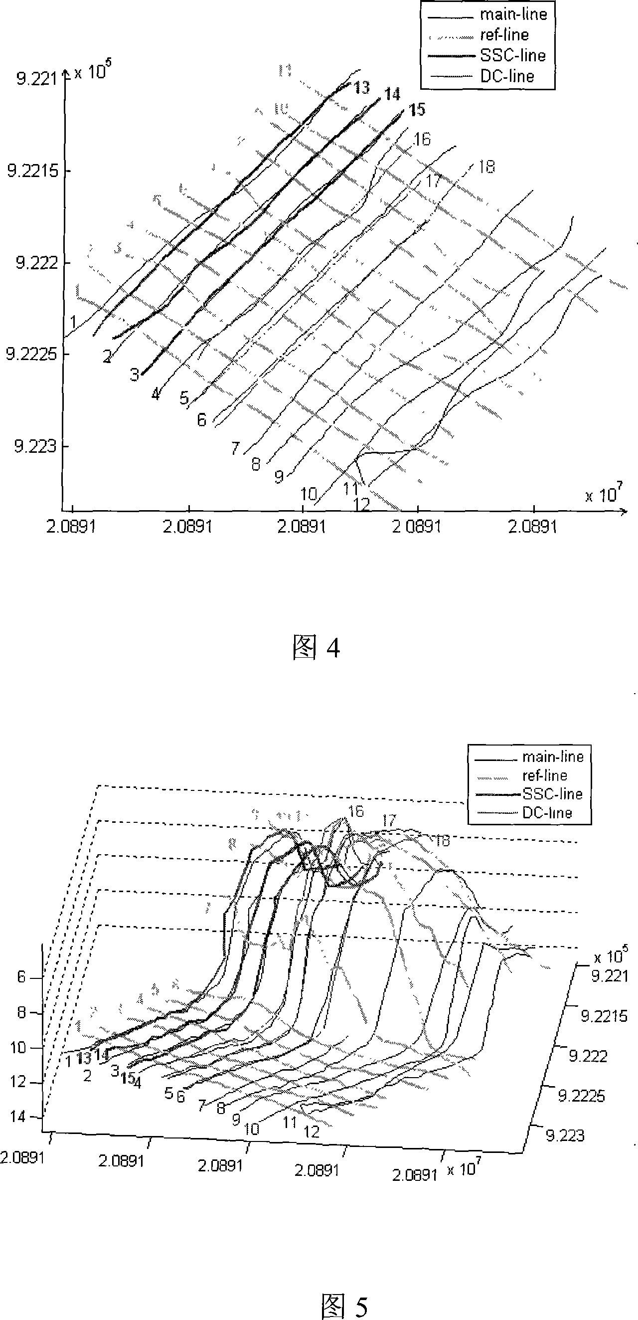
[0043] ◆There are 12 main measurement lines and 11 inspection lines. The main measurement lines and inspection lines are all measured under normal conditions. Light bold lines in Figures 4 and 5, numbered 1 to 11. During normal measurement, the standard sound velocity is 1510m / s, the draft of the transducer is 1.0m, and the speed is 7.5 knots.

[0044] ◆In order to test the influence of sound velocity on the measurement line system error, add three measurement lines as shown in Figure 4 and Figure 5 with black thick lines, numbered 13, 14, 15. The additional three sounding lines are variable sound velocity measurement, the sound velocity is 1490m / s, the draft is ...


PUM


Abstract

The invention relates to the marine surveying field, which is a systematical error testing and adjusting method of a marine surveying line net system. In the method, the first step is data acquisition, marine surveying line data which is obtained by a conventional measuring line method is transmitted in a computer by a data wire. In the second step, a computer data processing system performs the error detection of measured data of the marine surveying line net by a rank defect network adjustment principle: first, pictures are visualized and are edited, and a difference value of a junction is obtained, meanwhile, a difference value pie diagram of the junction is plotted, and the parameter results are obtained by the difference value circle analysis and the compensating computation. In the third step, tested testing data errors are adjusted, and systematic errors are corrected. The invention improves the precision of testing data of an entire region, avoids the resurvey and saves the measuring cost.

Description

Technical field [0001] The invention relates to the field of ocean surveying, in particular to detection and adjustment methods for system errors of ocean bathymetry, inland bathymetry, ocean gravity measurement and ocean magnetic force measurement carried out in surveying line mode. Background technique [0002] (1) At present, after the basic system items are corrected in the oceanographic survey based on the line survey mode, the difference between the cross points of the survey lines is used to check whether the result is qualified, and the difference between the cross points has not been used to detect system errors and improve the measurement. The precision of the results. (China's "Hydographic Specifications" (GB12327-1998) and the international "Hydographic Standards" (IHO, S44, 1998) (Chinese "Marine Gravity Measurement Specifications" (GJB89010-1990)); [0003] (2) Although some people have used the intersection point to determine the line system error in marine g...

Claims


Application Information

Patent Timeline
Patent Type & Authority Applications(China)
IPC IPC(8): G01C13/00G01C25/00G06F17/10G01F25/00
Inventor 刘雁春李明叁
Owner 刘雁春
Why Eureka
Try Eureka