Method and system for intercomparison of route

A path, longitude and latitude technology, applied in radio wave measurement system, satellite radio beacon positioning system, road network navigator, etc., can solve the problems of high equipment cost and operating cost

Inactive Publication Date: 2008-08-27
东方口岸科技有限公司 +1
View PDF0 Cites 22 Cited by
  • Summary
  • Abstract
  • Description
  • Claims
  • Application Information

AI Technical Summary

Problems solved by technology

The equipment cost and operating cost of the existing path comparison method are relatively high

Method used


Image

  • Method and system for intercomparison of route
  • Method and system for intercomparison of route
  • Method and system for intercomparison of route

Examples


Embodiment Construction

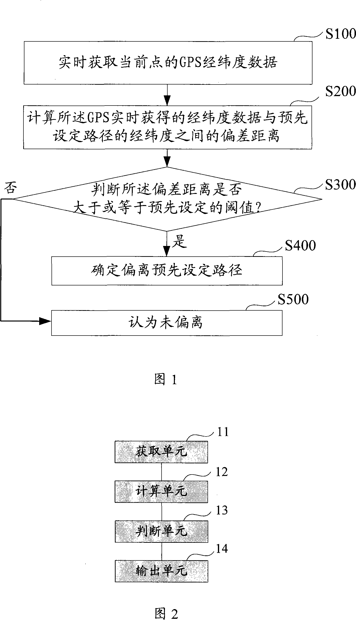
[0026] The invention provides a path comparison method, which can not only achieve the effect of path comparison, but also reduce the implementation cost.

[0027] Referring to FIG. 1 , this figure is a flow chart of the first embodiment of the path comparison method of the present invention.

[0028] The path comparison method described in the first embodiment of the present invention includes the following steps:

[0029] S100. Obtain GPS latitude and longitude data of the current point in real time.

[0030] The path comparison method described in the embodiment of the present invention can be applied to a mobile vehicle-mounted terminal device. By setting a GPS module on the vehicle-mounted terminal device, the GPS latitude and longitude data of the current point can be obtained in real time.

[0031] After the real-time acquisition of GPS latitude and longitude data, the real-time acquisition of GPS latitude and longitude data may be converted into a local data structure...


PUM


Abstract

The invention discloses a path intercomparison method, which comprises the following steps of: obtaining the GPS geographic coordinates data of a current point at real time; working out the deviation range between the geographic coordinates data obtained at real time and the geographic coordinates of a preset path; judging the deviation range is more than or equal to a preset threshold value; if yes, determining the fact of deviating from the preset path; if no, determining the fact of not deviating from the preset path. The invention provides the path intercomparison method and a path intercomparison system, thereby not only achieving the effect of path intercomparison, but also reducing the realization cost.

Description

technical field [0001] The invention relates to a path comparison method and system, in particular to a GPS-based real-time path comparison method and system. Background technique [0002] Existing path comparison methods, such as existing vehicle-mounted terminals, use GPS (Global Positioning System, Global Positioning System) positioning information in real time through CDMA (Code Division Multiple Access, Code Division Multiple Access) or GPRS (General Packet Radio Service, General Packet Radio Service) Service) wireless communication technology sent to the background, and then through GIS (Geographic Information System), the vehicle position is directly displayed on the GIS map interface, and the user judges whether it is offset from the specified vehicle position through the vehicle position displayed on the map interface and the actual position of the vehicle. path. [0003] In the prior art, vehicle-mounted terminals or mobile terminals not only need a GPS positionin...

Claims


Application Information

Patent Timeline
Patent Type & Authority Applications(China)
IPC IPC(8): G01C21/26G01C21/34G01S5/02G01S19/42
Inventor 曾燕珲戚天龙陈刚王毅
Owner 东方口岸科技有限公司
Why Eureka
Try Eureka