Route searching method based on mobile navigation system

A path search and path technology, applied in the field of path search in mobile navigation, can solve the problems of large number of nodes, limited hardware resources, and large memory consumption, etc., to reduce the number of diffuse nodes, improve search efficiency, and reduce data volume Effect

Active Publication Date: 2008-09-10
ZHEJIANG UNIV
View PDF0 Cites 17 Cited by
  • Summary
  • Abstract
  • Description
  • Claims
  • Application Information

AI Technical Summary

Problems solved by technology

[0004] In the navigation path search, the currently generally used method is mainly based on the Dijkstra algorithm. This method is a general method for path search, which does not make full use of the characteristics of the navigation system, and the nodes that need to be recorded during the sea...

Method used


Image

  • Route searching method based on mobile navigation system
  • Route searching method based on mobile navigation system

Examples


Embodiment 1

[0074] Taking Hangzhou city as an example, the current starting position is (30.26331, 120.12111), the direction is (107.94 degrees), and the selected target point is (30.27751, 120.18615).

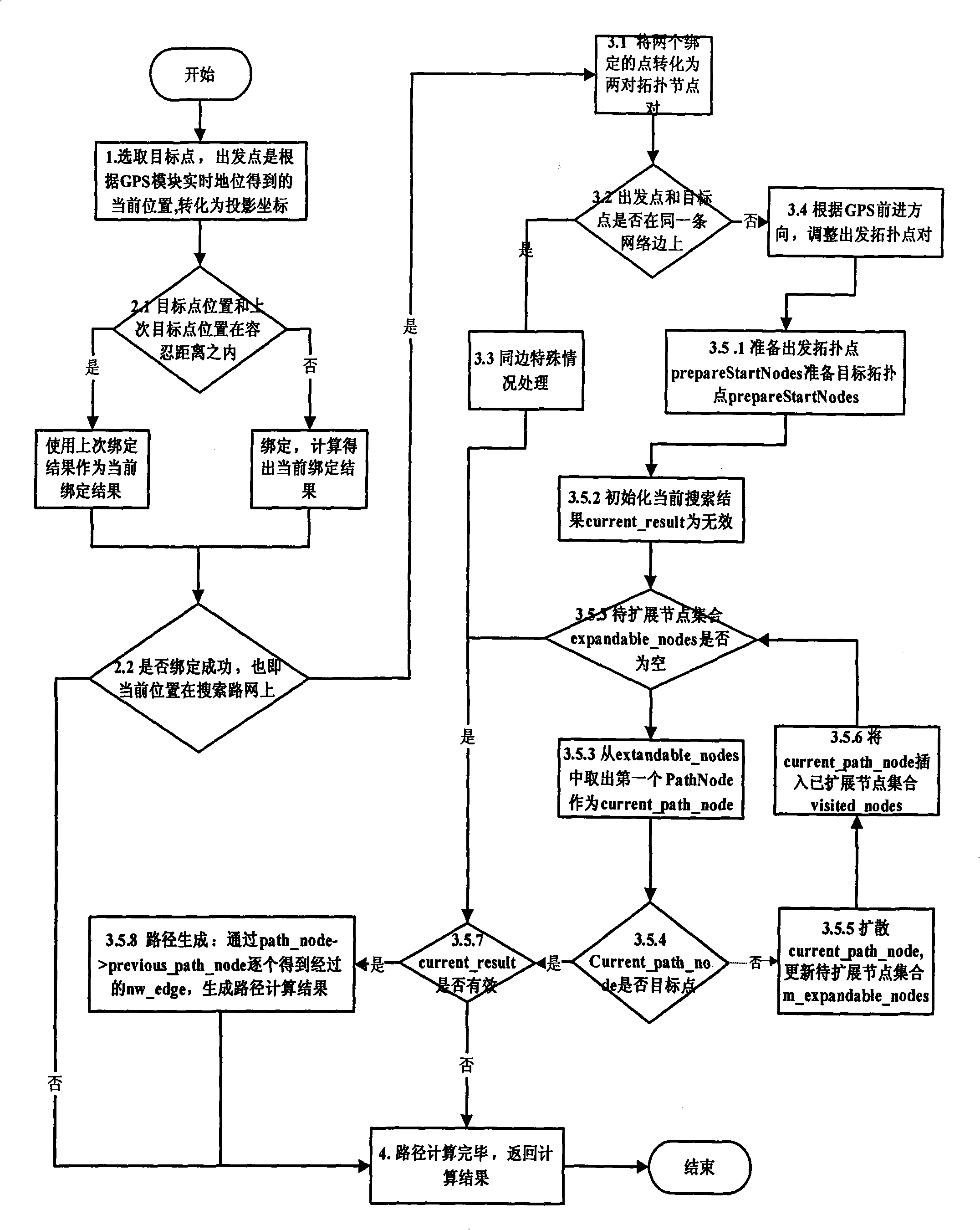
[0075] 1. Select the target point:

[0076] Get the current position and orientation, convert to projected coordinates,

[0077] The projected position of the starting point is (3531330.1, 13349507.2),

[0078] The projected position of the target point is (3533340.3, 1335664.2);

[0079] The direction is 1.88391 radians;

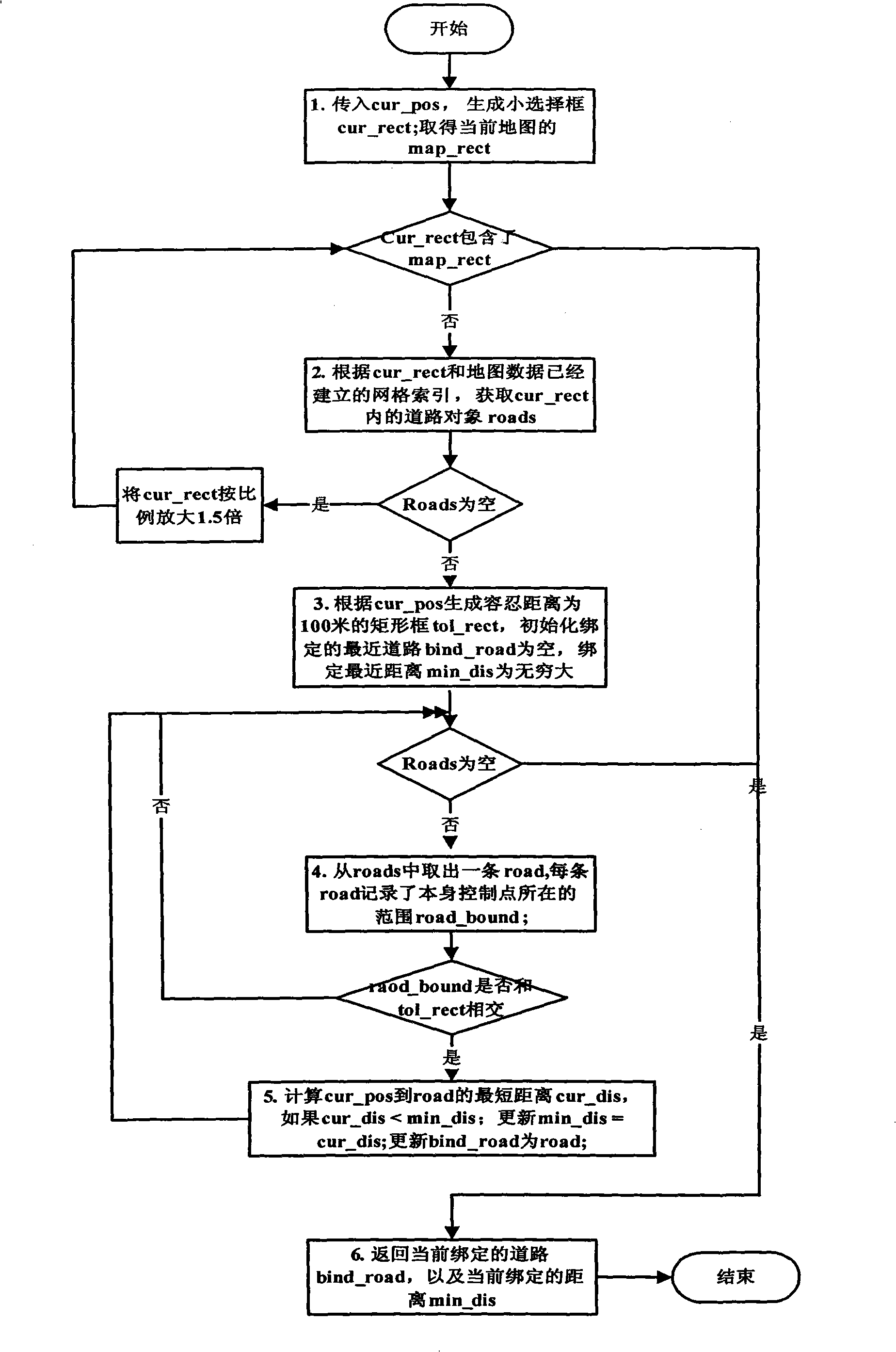
[0080] 2. Binding road:

[0081] The nearest road to the starting point is Zheda Road, and the binding distance is 23 meters.

[0082] The nearest road bound to the target point is Kaixuan Road, and the binding distance is 47 meters;

[0083] 3. Convert the binding result into a topological node pair:

[0084] The starting topology node pair is:

[0085] start_nw_node1: coordinates (3531328.2, 13350005.1), direction (1.91815 radians), distance (578.863 meters); ...

Embodiment 2

[0115] Taking Hangzhou city as an example, the current starting position is (30.26331, 120.12111), the direction is (107.94 degrees), and the selected target point is (30.27751, 120.18615).

[0116] The result of converting to projected coordinates is:

[0117] The projected position of the starting point is (3531330.1, 13349507.2),

[0118] The projected position of the target point is (3533340.3, 1335664.2);

[0119] The direction is 1.88391 radians;

[0120] Binding to the nearest road results in:

[0121] The nearest road to the starting point is Zheda Road, and the binding distance is 23 meters.

[0122] The nearest road bound to the target point is Kaixuan Road, and the binding distance is 47 meters;

[0123] The path search results are:

[0124] The number of diffusion nodes is 55, the total length of the path is 8107.556 meters, and the roads passed by the path are: Zhejiang University Road-"Shuguang Road-"Sports Stadium Road-"Kaixuan Road;


PUM


Abstract

The invention discloses a path search method based on a moving navigation system, which is based on the characteristic of the navigation system, uses the known information of the objective point position as the starting information of the search process, uses the starting information to re-design the path search method, and leads the number of the nodes extended in the search process to be greatly reduced, thus reducing the occupying of the memory and improving the search efficiency.

Description

technical field [0001] The invention relates to the field of path search in mobile navigation, in particular, to a path search method based on a mobile navigation system. Background technique [0002] The mobile navigation system is generally divided into the following modules: navigation data loading, navigation map display, navigation path search, and navigation prompt analysis module. [0003] The mobile navigation system receives the current location in real time through the GPS device, and sometimes needs to recalculate the route during the navigation process, and because the hardware resources of the mobile device are limited, the efficiency and memory consumption of the route search algorithm are more stringent. [0004] In the navigation path search, the currently generally used method is mainly based on the Dijkstra algorithm. This method is a general method for path search, which does not make full use of the characteristics of the navigation system, and the nodes ...

Claims


Application Information

Patent Timeline
IPC IPC(8): G01C21/34G06F17/30
Inventor 陈奇赵国荣李山亭黄群山徐亚娟范先迪蒋卫星
Owner ZHEJIANG UNIV
Why Eureka
Try Eureka