Near-bit geological guiding probe system

A geosteering and detection system technology, applied in the wireless transmission of near-drill measurement and downhole measurement data, in the field of near-drill geosteering detection systems, can solve the problems that data cannot be directly transmitted to the ground, the detection range is reduced, and the transmission rate is reduced.

Inactive Publication Date: 2008-10-22
CNPC DRILLING RES INST
View PDF2 Cites 39 Cited by
  • Summary
  • Abstract
  • Description
  • Claims
  • Application Information

AI Technical Summary

Problems solved by technology

[0003] However, in the current drilling engineering, the sensors of many drilling systems have a certain distance from the drill bit, which reduces the detection range and detection accuracy.
Although the sensors in some drilling systems are installed very close to the drill bit, there is no formation resistivity detector in the formation parameters, and when the data collected by the sensors is uploaded, the transmission channel is a wireless short transmission channel, and the data cannot be directly transmitted to the ground , must be relayed and then transmitted to the ground, which greatly reduces the transmission rate

Method used


Image

  • Near-bit geological guiding probe system
  • Near-bit geological guiding probe system
  • Near-bit geological guiding probe system

Examples


Embodiment

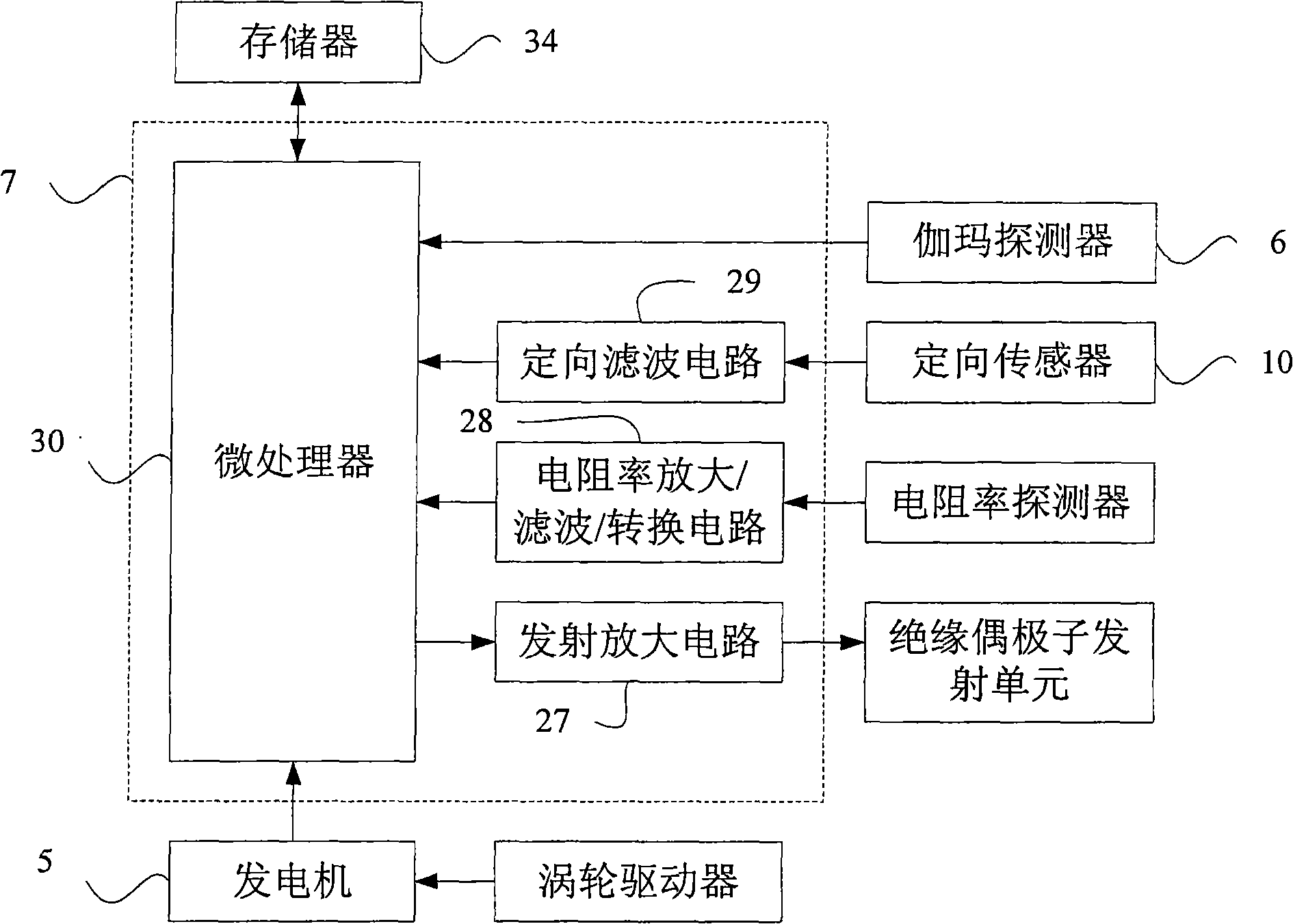
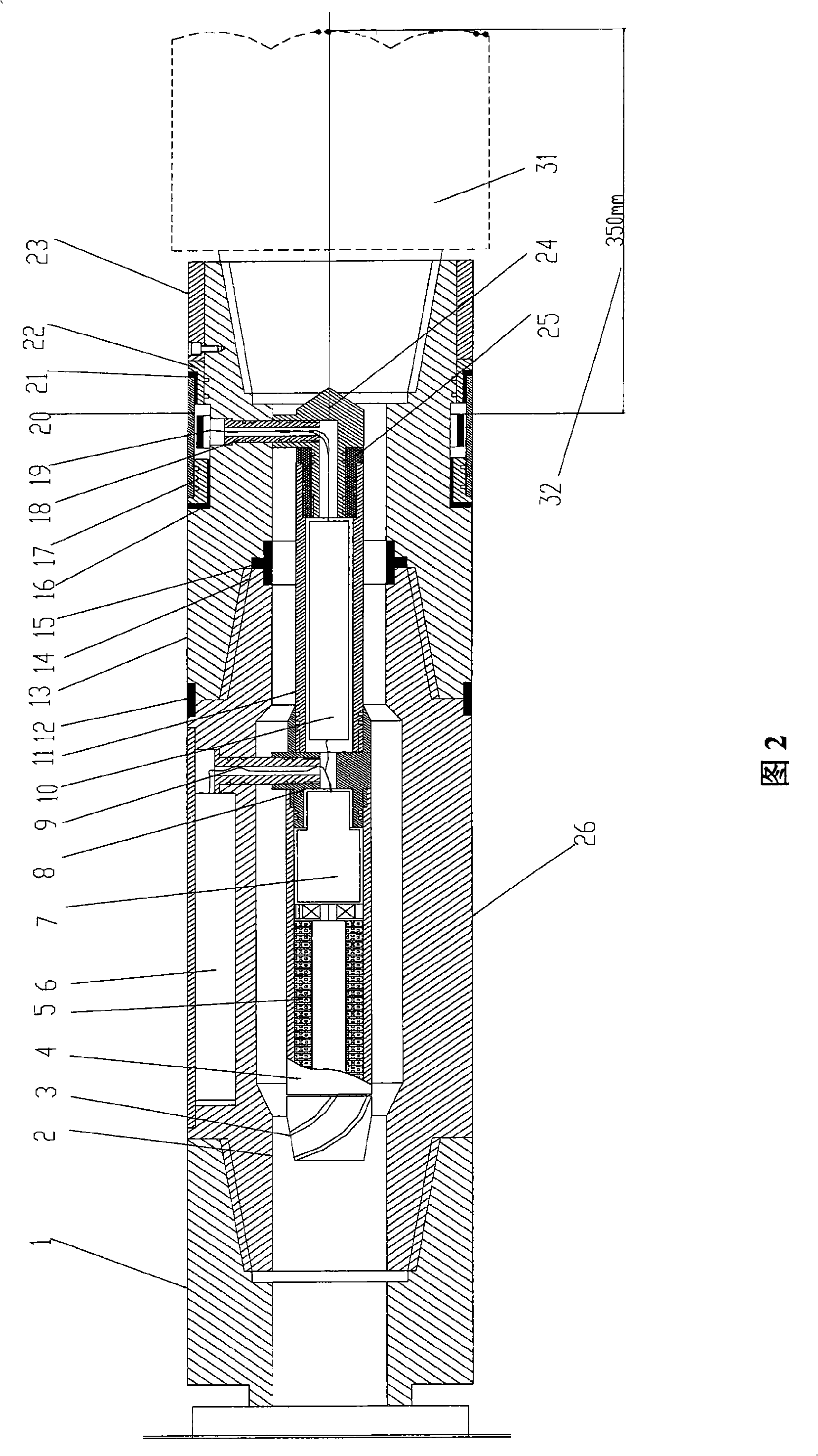
[0029] In this embodiment, two sections of titanium alloy short joints (26, 13) connected through insulation are used as the substrate, and on this basis, the integrated integration of the geosteering system and the drill bit is realized. The geosteering system formed by this method has the following nearly Drill bit measurement functions: ① formation resistivity measurement near the drill bit; ② gamma ray measurement near the drill bit; ③ well deviation and tool face measurement near the drill bit; ④ various measurement data are transmitted to the ground at one time through the wireless electromagnetic channel.

[0030] The geosteering system integrated with the drill bit is composed of the following parts: the first titanium alloy short joint 26, the second titanium alloy short joint 13, the sealing insulating ring 12, the insulating ring 15, the insulating ring 14, the insulating ring 16, and the insulating ring 17 1. The formation resistivity detector near the drill bit for...


PUM


Abstract

The invention provides a near-bit geology guide detecting system, comprising an electricalresistivity detecting unit, a gamma detecting unit, a position sensing unit and an insulating dipole transmitting unit, wherein the electricresistivity detecting unit is used for measuring the electricresistivity a near-bit stratum to generate electricresistivity data; the gamma detecting unit is used for measuring near-bit gamma rays to generate gamma ray data; the position sensing unit is used for measuring near-bit inclination and an implemental surface to generate position data; and the insulating dipole transmitting unit is used for transmitting the electricresistivity data, the gamma ray data and the position data to the ground through a wireless electromagnetic signal channel. A sensor is close to the near bit as much as possible, so when a drill drills into the sensor, the sensor makes an early prediction to information of the front part of the drill and information of the periphery stratum of the drill, thereby the aim of geology guide is achieved during drilling process.

Description

technical field [0001] The present invention relates to measurement while drilling or geosteering measurement technology in logging while drilling for petroleum, mining and geological exploration, especially relates to near-drill bit measurement and wireless transmission technology of downhole measurement data, specifically a near-drill bit geosteering detection system. Background technique [0002] In drilling projects such as petroleum, mining, and geological exploration, it is required to make the drilling trajectory more accurate and drill according to the engineering design requirements, timely and accurately grasp formation information to identify thin oil layers to improve drilling efficiency, and transmit formation information to the ground in real time. In this way, engineers and technicians can keep abreast of wellbore trajectory and formation information changes. [0003] However, in the current drilling engineering, the sensors of many drilling systems have a ce...

Claims


Application Information

Patent Timeline
Patent Type & Authority Applications(China)
IPC IPC(8): E21B47/12G01V5/12E21B47/13
Inventor 苏义脑盛利民李林窦修荣邓乐
Owner CNPC DRILLING RES INST
Why Eureka
Try Eureka