

Vehicle mounted investigation method and system of large scale crops planting area
A large-scale, crop-based technology, applied in surveying, mapping and navigation, measuring devices, instruments, etc., can solve the problems of insufficient objective data, not officially included in the government statistics system, satellite data accuracy is not suitable for autumn grain crops, etc., to reduce labor intensity, Effect of improving survey accuracy
Active Publication Date: 2010-08-25
ACADEMY OF PLANNING & DESIGNING OF THE MINIST OF AGRI +1
View PDF0 Cites 1 Cited by
- Summary
- Abstract
- Description
- Claims
- Application Information
AI Technical Summary
Problems solved by technology
At present, my country mainly obtains the planting area information of large-scale crops in the country through the ground sampling of the Bureau of Statistics and the level-by-level statistical reporting of the Ministry of Agriculture. It is greatly affected by human factors and the data are not objective enough.
Although remote sensing yield estimation is timely and objective, the acquisition of remote sensing image data is greatly affected by weather, which has the following disadvantages: ①In practice, the accuracy of satellite data is not suitable for distinguishing intercropping autumn grain crops; ②The acquisition of remote sensing image data is greatly affected by weather, especially The acquisition rate of satellite images during the rice growing season in southern China is only 6%, which makes the remote sensing stratified sampling method problematic in areas without images
③Satellite image data is expensive and not suitable as the only data source for national and long-term monitoring of crop planting area
Although 3S spatial information technology based on remote sensing (RS), GIS, and GPS monitors crop area in a timely and objective manner, it has not been officially included in the government statistics system due to the lack of operational normative methods and accuracy assessment.
Method used
View moreImage
Smart ImageViewing Examples

Examples
Embodiment Construction
Login to View More PUM
 Abstract
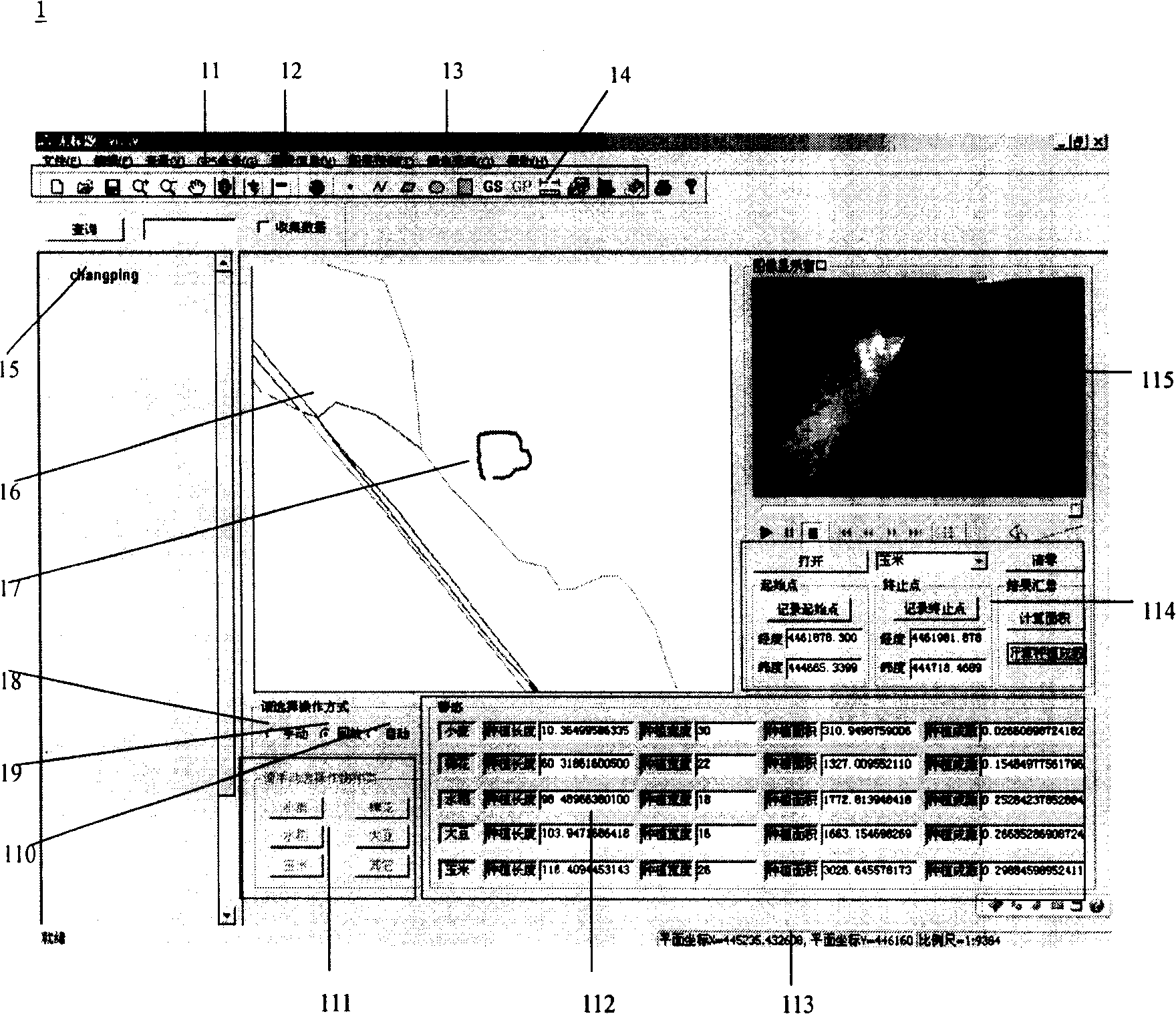
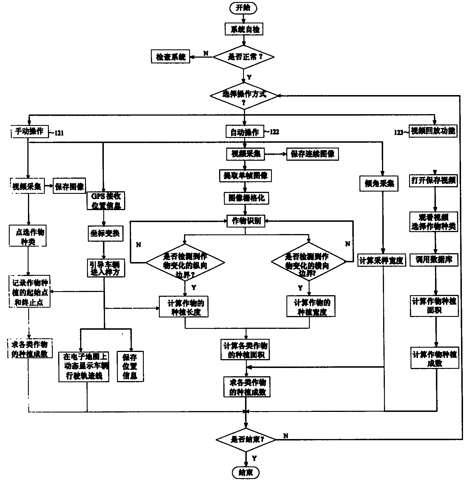
The invention discloses a large scale crop plant area vehicle-carrying investigation process and a system thereof, which comprises the matching of GPS position information and a GIS map, the matching of GPS position information and images, the decision of crop longitudinal plant width, the storage and extraction of the images, the grid algorism of the images, the identification of crop species, the storage of GPS position information and the various crops plant information and the calculation of various crops plant area and plant quotas. The process and the system can realize the drawing of vehicle navigation and path line through the GPS position information, measure the shooting angle of a camera through a dip angle sensor and control the quadrat width of a sampling, realize the video storage of the sampling and the single-frame extraction of a to-be-identified image through the image collection, and increase the real-time and the accurate ratio of identification through the grid algorism of the images, and automatically calculate the plant areas of various large scale crops through the crop identification. The system provides three ways of hand-held function, automatic functionand the video playback function to calculate the plant area of crops and the plant quota.
Description
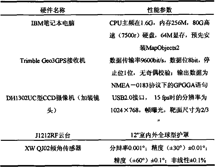
field of invention The invention relates to a vehicle-mounted investigation method and system for large-scale crop planting area. Through the development, application and combination of GPS, GIS, image processing and image recognition technologies, the calculation of large-scale crop planting area and planting percentage is completed, and the classification is carried out. Save to the corresponding database. In particular, users can choose manual function, automatic function and video playback function to complete the calculation of crop planting area and planting percentage according to their needs, thus meeting the different needs of users. Background technique my country is a large agricultural country, and food security is a problem that our government attaches great importance to. Accurate forecasting of crop yields is of great significance for the formulation of national food policies, the development of rural economy, and foreign food trade. Under the conditions of n...
Claims
Login to View More Application Information
Patent Timeline
 Patent Type & AuthorityPatents(China)
IPC IPC(8): G01C11/00G01C21/00
Inventor杨邦杰毛恩荣焦险峰马蓉王素霞汪庆发宋正河裴志远张蕊
OwnerACADEMY OF PLANNING & DESIGNING OF THE MINIST OF AGRI