Mobile robot grating map creating method of real-time data fusion

A mobile robot and grid map technology, applied in physical realization, biological neural network model, road network navigator, etc., can solve the problems of overly sensitive error information, high misjudgment rate, and low accuracy

Inactive Publication Date: 2009-04-22
HUNAN UNIV
View PDF0 Cites 69 Cited by
  • Summary
  • Abstract
  • Description
  • Claims
  • Application Information

AI Technical Summary

Problems solved by technology

Analysis and experiments show that the map produced by the probability-based method has high precision and clear contours, but it is too sensitive to wrong information and has a high misjudgment rate; while the fuzzy logic method has high robustness, and the map has a high degree of information uncertainty. is still stable, but the accuracy is low and the resulting map is not clear

Method used


Image

  • Mobile robot grating map creating method of real-time data fusion
  • Mobile robot grating map creating method of real-time data fusion
  • Mobile robot grating map creating method of real-time data fusion

Examples


Embodiment 1

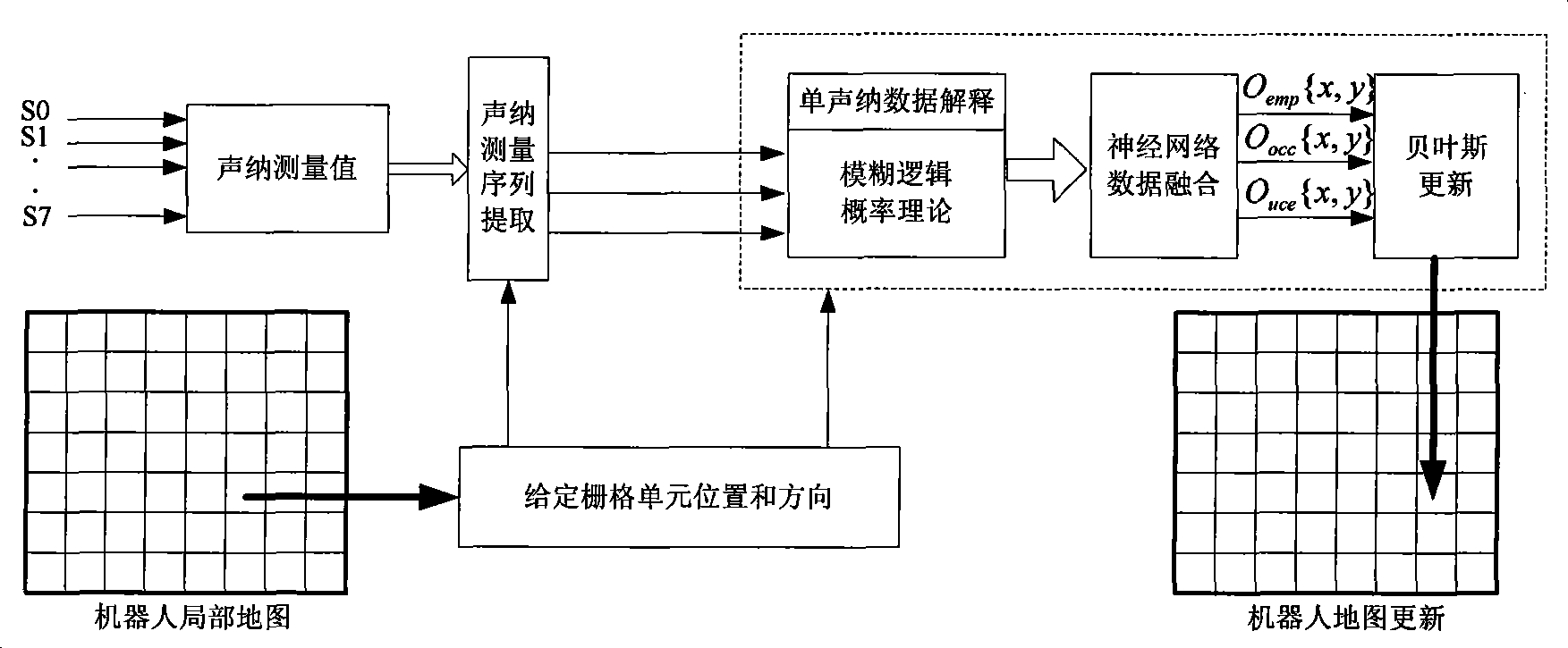
[0055] The present invention proposes a real-time data fusion mobile robot grid map creation method, the system schematic diagram is as follows figure 1 shown. The neural network is used to fuse the uncertainty of sonar data explained by probability theory and fuzzy logic, and the influence of the spatial correlation of multiple sonars on the state of the same grid is considered to establish an environmental grid map.

[0056] figure 1 Among them, S0, S1, ..., S7 are the ranging values ​​of the sonar sensors installed on the front end of the mobile robot, and O emp {x, y}, O occ {x, y}, O uce {x, y} are the currently calculated grid idle probability, obstacle probability and uncertain state probability, respectively.

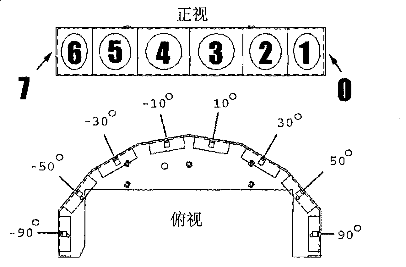
[0057] The mobile robot uses ultrasonic ranging sensors to complete environment modeling, and eight sonar ranging sensors are installed on its front end. figure 2 The positions of the sonar sensors of the mobile robot are: ±10°, ±30°, ±50° and ±90°, which ...


PUM


Abstract

The invention provides a building method of a grid map by a mobile robot based on real-time data fusion. The method comprises the following steps: artificially dividing an environment into a plurality of grids with the same size, and obtaining the distance information by sonar sensors arranged on the front end of the mobile robot; extracting measured values of three sonar sensors which are closest to a currently computed grid unit at the same time, respectively explaining a single sonar data by a fuzzy logic and a probability theory so as to obtain a group of characteristic vectors which are subject to the data fusion as input vectors of a neural network, wherein, output values of the neural network comprises idle state, busy state and undefined state of the grid; finally updating the state of the grid by the Bayes rule. The mobile robot of the invention obtains the environmental information by sonar ranging finders and completes the environmental modeling, thus providing reliable basis for the subsequent autonomous navigation of the mobile robot.

Description

technical field [0001] The invention belongs to the technical field of robots and artificial intelligence, and relates to a real-time data fusion mobile robot grid map creation method. Background technique [0002] In the past 20 years, with the rapid development of artificial intelligence technology and computer technology, research on autonomous intelligent mobile robots has received significant attention. It requires the ability to automatically obtain surrounding environmental information through its own sensors such as rangefinders, cameras, infrared, etc., establish a spatial environment model and identify its own current position, and move along an automatically planned effective path to complete specific tasks. At present, intelligent mobile robots are widely used in industry and agriculture, transportation, military, medical and health industries, etc., to solve work problems in dangerous environments and replace human heavy work. In order to improve the working ab...

Claims


Application Information

Patent Timeline
Patent Type & Authority Applications(China)
IPC IPC(8): G01C21/32G06N3/06
Inventor 王耀南朱江许海霞余洪山邓霞孙程鹏宁伟胡淼
Owner HUNAN UNIV
Why Eureka
Try Eureka