Simulation method used for woodland complex scene high-spectrum remote sensing data

A technology for hyperspectral remote sensing and complex scenes, applied in electrical digital data processing, special data processing applications, instruments, etc.

Inactive Publication Date: 2009-07-08
HARBIN INST OF TECH
View PDF0 Cites 11 Cited by
  • Summary
  • Abstract
  • Description
  • Claims
  • Application Information

AI Technical Summary

Problems solved by technology

[0006] In order to solve the problem that the existing hyperspectral remote sensing data simulation method fails to consider the height factor of ground objects and is not suitable for hyperspectral remote sensing data simulation under the condition that there are tall buildings near the forest land, the present invention proposes a method for forest land Simulation Method of Hyperspectral Remote Sensing Data in Complex Scenes

Method used


Image

  • Simulation method used for woodland complex scene high-spectrum remote sensing data
  • Simulation method used for woodland complex scene high-spectrum remote sensing data
  • Simulation method used for woodland complex scene high-spectrum remote sensing data

Examples


specific Embodiment approach 1

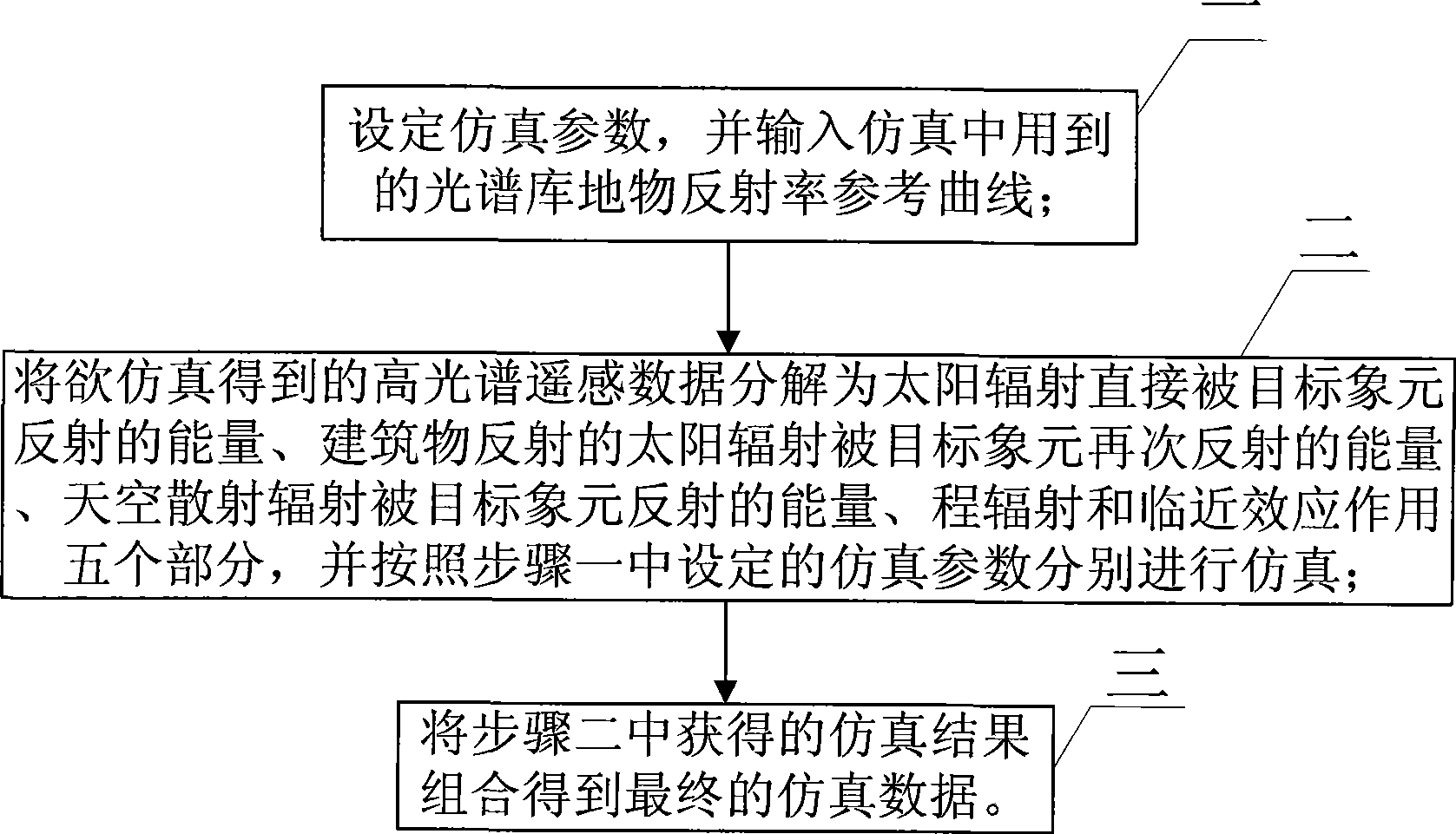
[0013] Specific implementation mode one: combine figure 1 Describe this embodiment, the steps of this embodiment are as follows:

[0014] Step 1: Set the simulation parameters, and input the reference curve of reflectance of the spectral library used in the simulation;

[0015] Step 2: Decompose the hyperspectral remote sensing data to be simulated into the energy directly reflected by the target pixel of the solar radiation, the energy of the solar radiation reflected by the building being reflected again by the target pixel, and the energy of the scattered radiation of the sky reflected by the target pixel , range radiation and proximity effect, and simulate them respectively according to the simulation parameters set in step 1;

[0016] Step 3: Combine the simulation results obtained in Step 2 to obtain the final simulation data.

specific Embodiment approach 2

[0017] Embodiment 2: The difference between this embodiment and Embodiment 1 is that the simulation parameters in step 1 are divided into two groups, namely: surface scene parameters and atmospheric scene parameters;

[0018] The surface scene parameters are ground scene size, resolution unit size (GSD), object classification of each unit, tree type, average tree height, tree canopy size, plant density and building height; the tree canopy size is simplified as an ellipsoid , whose magnitude is determined by the major and minor axes.

[0019] The atmospheric scene parameters are the zenith angle of the sun incident direction, the azimuth angle of the sun incident direction, the zenith angle of the sensor observation direction, the azimuth angle of the sensor observation direction, MODTRAN parameters, spectral range and spectral resolution.

[0020] Other steps are the same as in the first embodiment.

specific Embodiment approach 3

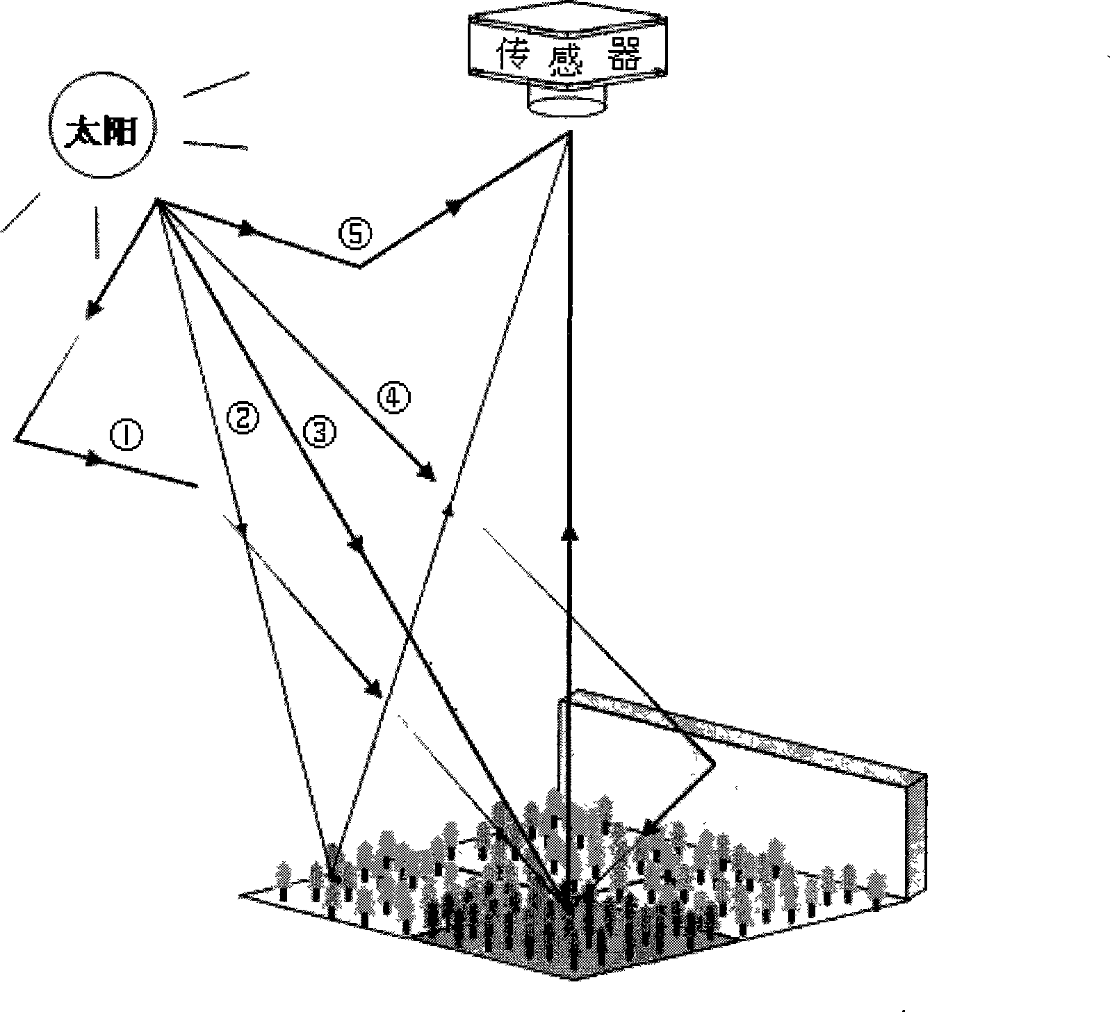
[0021] Specific implementation mode three: combination Figure 2 to Figure 5 Describe this implementation mode. The difference between this implementation mode and specific implementation mode 1 lies in step 2. Step 2 is to fully consider the impact of various factors on the acquisition of hyperspectral remote sensing data, such as figure 2 It is to divide the hyperspectral remote sensing data into the energy of solar radiation directly reflected by the target pixel The solar radiation reflected by the building is reflected again by the target pixel The energy of sky scattered radiation reflected by the target pixel Range Radiation L λ,sky and the proximity effect L λ,adjacent five parts. So the total radiation is the irradiated energy L at the final data sensor obtained by simulation λ,sensor It can be expressed by formula (1):

[0022] L λ , sensor = L ...


PUM


Abstract

The invention provides a method for emulating high spectroscopic remote sensing data used in a woodland complex scene, relates to the technical field of high spectroscopic remote sensing data emulation, and solves the problem that the prior method for emulating the high spectroscopic remote sensing data is not applicable to the high spectroscopic remote sensing data under the condition that a tall building exists near the woodland as height factor of a ground object is not considered. The method comprises the following steps: 1, setting an emulation parameter, and inputting a reference curve of ground and object reflectivity of a spectrum library used in emulation; 2, resolving high spectroscopic remote sensing data to be acquired in emulation into energy of solar radiation directly reflected by a target pixel element, energy of building reflected solar radiation which is reflected by the target pixel element once again, energy of sky radiation scattering which is reflected by the target pixel element, path radiation and proximity effect, and carrying out emulation respectively according to the emulation parameter in the step 1; and 3, combining emulation results acquired in the step 2 to acquire the final emulation data. The method provides economic and high-quality emulation data for research of post-processing of the high spectroscopic remote sensing data.

Description

technical field [0001] The invention relates to the technical field of hyperspectral remote sensing data simulation. Background technique [0002] Hyperspectral remote sensing technology is a new type of optical remote sensing technology that combines conventional remote sensing imaging technology with spectral technology. Its appearance has greatly broadened the application field of optical remote sensing. Hyperspectral remote sensing can obtain nearly continuous narrow-band spectral information of each pixel while imaging the spatial characteristics of the target object. In this way, not only the spatial characteristics of the ground target, but also its rich spectral information can be obtained, and then the measured object can be physically analyzed and identified qualitatively and quantitatively, so that the remote sensing recognition of the target ground object based on the characteristic spectral information becomes possible. This makes hyperspectral remote sensing t...

Claims


Application Information

Patent Timeline
Patent Type & Authority Applications(China)
IPC IPC(8): G01S7/48G06F17/50
CPCY02E60/76Y04S40/22Y02E60/00
Inventor 邹斌陈东来张钧萍张腊梅顾桂华
Owner HARBIN INST OF TECH
Why Eureka
Try Eureka