Mobile communication network coverage simulation interactive regulation method based on GIS

A mobile communication network and adjustment method technology, which is applied in the field of GIS-based mobile communication network coverage simulation and interactive adjustment, can solve the problems that cannot truly reflect the overall situation and reality of network coverage, limitations of basis and accuracy, waste of human and material resources, etc. problems, to achieve the effect of saving on-site road testing and repeated adjustment work, accurate coverage planning and optimization, and improving precision and accuracy

Inactive Publication Date: 2009-07-08
西安方诚通讯技术服务有限公司
View PDF0 Cites 19 Cited by
  • Summary
  • Abstract
  • Description
  • Claims
  • Application Information

AI Technical Summary

Problems solved by technology

[0003] 1) The tested data are only some sampling points or local data, which cannot truly reflect the overall and actual network coverage;
[0004] 2) Manual debugging is only based on experience, so there are serious limitations an

Method used


Image

  • Mobile communication network coverage simulation interactive regulation method based on GIS
  • Mobile communication network coverage simulation interactive regulation method based on GIS

Examples


Embodiment Construction

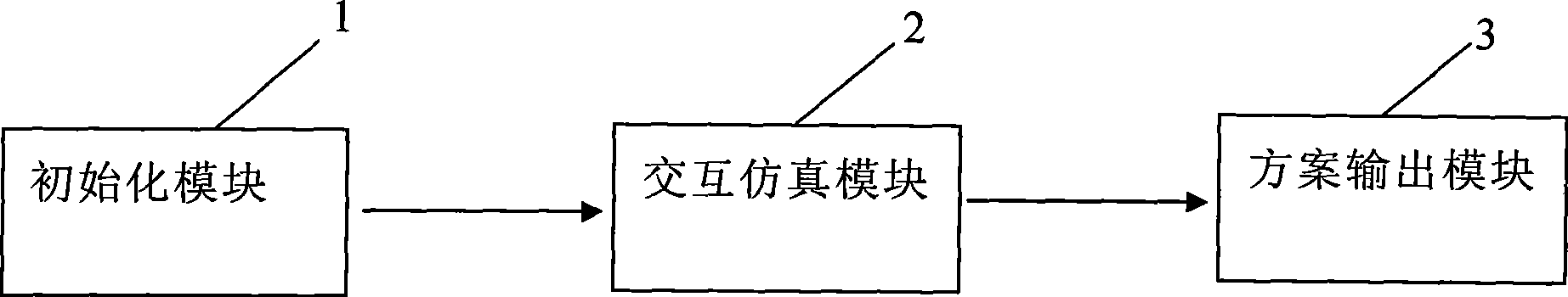
[0026] Such as figure 1 The computer shown for the mobile communication network coverage simulation interactive adjustment method includes an initialization module 1 for importing data, the initialization module 1 transmits the data to the interactive simulation module 2, and the interactive simulation module 2 outputs the data to the solution output module 3 for output display .

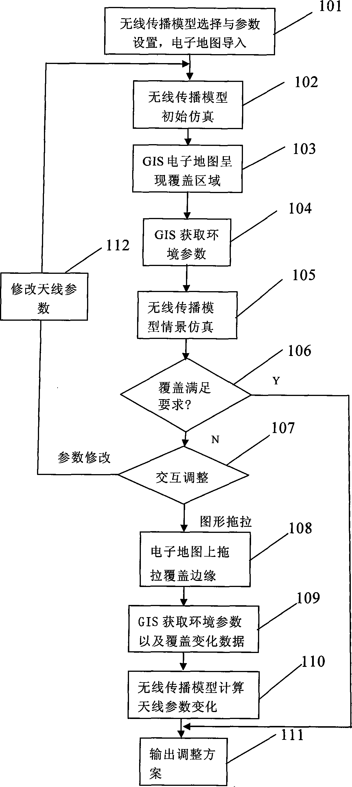
[0027] Such as figure 2 The shown GIS-based mobile communication network coverage simulation interactive adjustment method uses a computer to adjust the GSM communication network coverage simulation interactive adjustment, and the method includes the following steps:

[0028] (1) Step 101: The computer's initialization module 1 imports the vector electronic map of the area to be adjusted, and selects the COST-231-Walfish-Ikegami model from the radio wave propagation model library. The model library includes the 0kumura-Hata model, the COST-231 model, COST-231-Walfish-Ikegami model, Epstein-Peterson mod...


PUM


Abstract

The invention relates to mobile communication network covering emulation interactive adjustment method based on GIS, and comprises the following procedures: a GIS geographical information system and a radio-wave transmission model are used for changing antenna parameter through emulation; the radio-wave transmission model is used for calculating the covering range; the space background property of the covering area obtained from an electric map is taken as the basic parameter, modifying factor and additional parameter and the like in the radio-wave transmission model, and the calculation result of the revised model meets the expected requirement; the covering edge is dragged in the electric map to meet the covering demand, the antenna parameter is extrapolated through the radio-wave transmission model, comprising suspending height, direction angle and inclination angle, etc, as an adjustment scheme, thereby realizing the real-time, the present-environment interactive emulation adjustment of the antenna parameter and the covering property. The method raises the precision and accuracy of emulation, saves great deal of on-site route exploration work and repeated adjustment work, allows covering planning and optimization to be more correct, and provides a firm basis for the plan, evaluation and optimization of network.

Description

Technical field [0001] The invention belongs to the field of communication technology and computer application, and specifically relates to a GIS-based mobile communication network coverage simulation interactive adjustment method. Background technique [0002] The existing mobile communication coverage optimization is mainly aimed at blind spots, weak coverage areas, cross-area coverage, etc. found in the wireless network optimization drive test. Manual adjustments are made based on experience, and repeated many times until the blind spots disappear or the signal becomes stronger. Or cross-area coverage elimination. If it still cannot be solved, consider adding and subtracting base stations to solve it. The disadvantages of this method are: [0003] 1) The tested data are only some sampling points or partial data, which cannot truly reflect the global and actual coverage of the network; [0004] 2) Manual debugging is only a trial based on experience, so the basis and accuracy o...

Claims


Application Information

Patent Timeline
IPC IPC(8): H04W16/18
Inventor 于友成郭方宇
Owner 西安方诚通讯技术服务有限公司
Why Eureka
Try Eureka