Method for automatically updating land-use map based on historical data and remote sensing data

A technology of historical data and remote sensing data, applied in the directions of maps/plans/charts, educational tools, instruments, etc., can solve the problems of inability to realize the automatic update of land use maps, large change detection errors, etc., to improve the automatic update process and realize automation. , the effect of broad market prospects and application value

Inactive Publication Date: 2009-08-19
REMOTE SENSING APPLIED INST CHINESE ACAD OF SCI
View PDF0 Cites 33 Cited by
  • Summary
  • Abstract
  • Description
  • Claims
  • Application Information

AI Technical Summary

Benefits of technology

This patented technology helps analyze past lands' usage patterns over large amounts of space while reducing errors due to different environmental conditions or human error. By analyzing these datasets from older ones, it becomes possible to identify new developments without being affected by any previous actions. Additionally, this analysis allows us to create models based on both geographic location and sensor imagery, allowing for more accurate monitoring of changing locations and identification of potential issues related to soil management practicality. Overall, this system improves efficiency and accuracy during land-use change detection processes like updates and model construction.

Problems solved by technology

Technologies described in the technical problem addressed in this patents involve improving understanding of ground activity mapping systems from satellite imagery to space science applications. These advancements aim towards better understanding spatial patterns over longer distances called long range areas, including vegetation dynamics, landslide movements, and urban siding movement. Ground surface models have become increasing popular due to increased interest in studying environmental issues related to human activities like agricultural production. They help predict future crop growth scenarios and develop new farming techniques. Overall, they offer valuable insights into how well known factors affect soil behavior during natural events and improve efficiency in managing crops' impact on local environments.

Method used


Image

  • Method for automatically updating land-use map based on historical data and remote sensing data
  • Method for automatically updating land-use map based on historical data and remote sensing data
  • Method for automatically updating land-use map based on historical data and remote sensing data

Examples


Embodiment Construction

[0025] In order to better understand the technical solution of the present invention, the present invention will be described in detail below in conjunction with the accompanying drawings and specific embodiments.

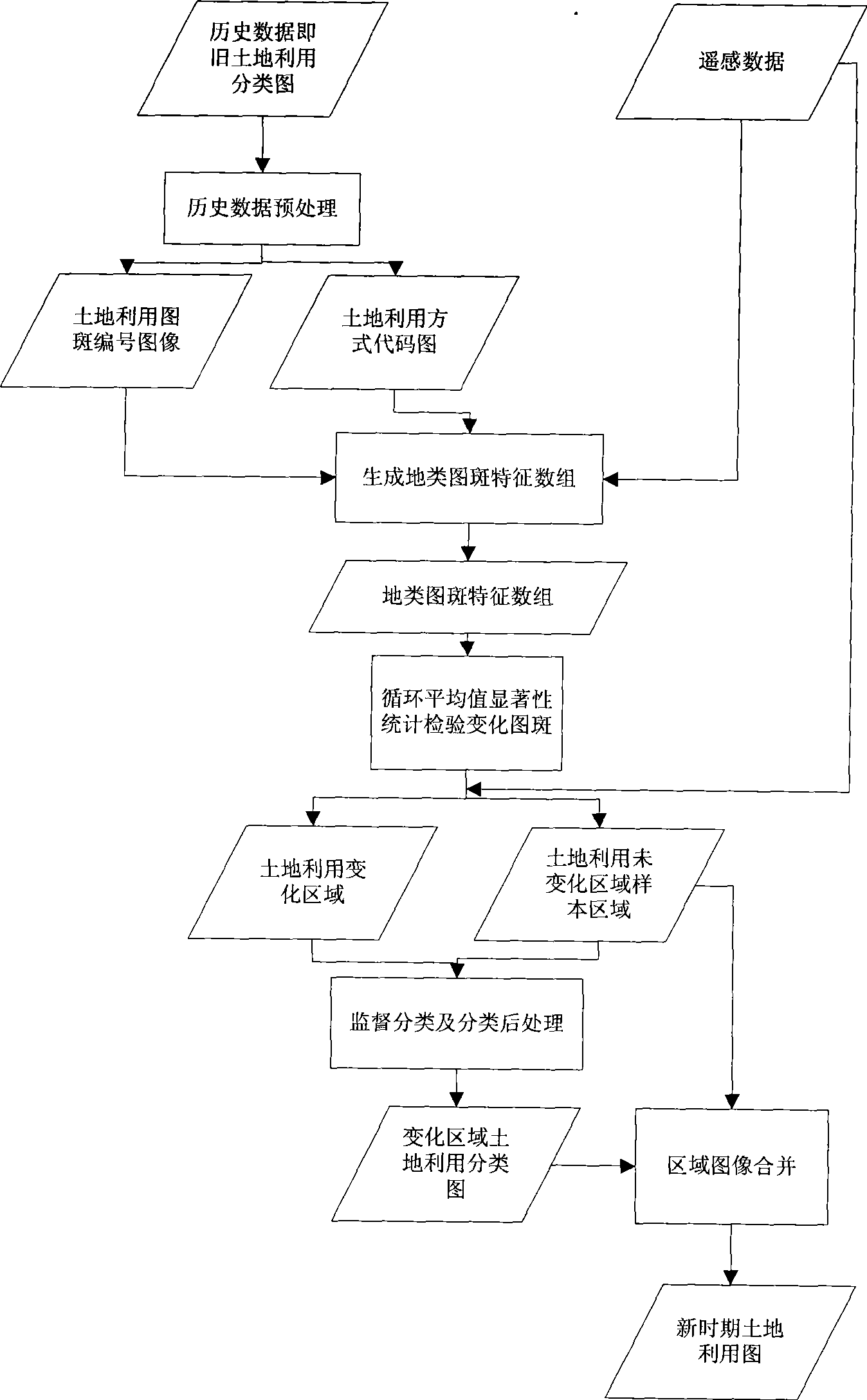
[0026] A method for automatically updating land use maps based on historical data and remote sensing data of the present invention, the method mainly includes the following steps:

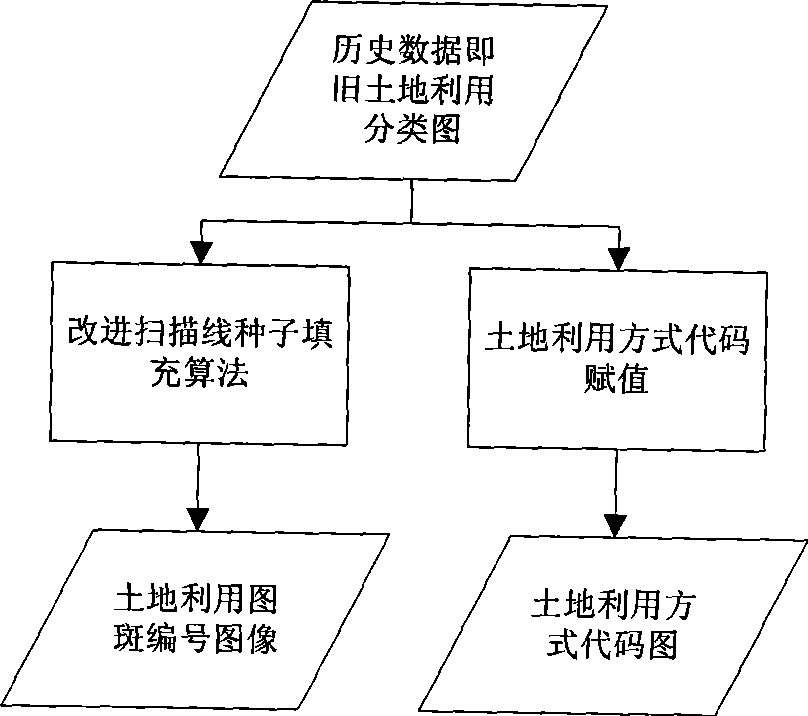
[0027] 1. Historical data preprocessing;

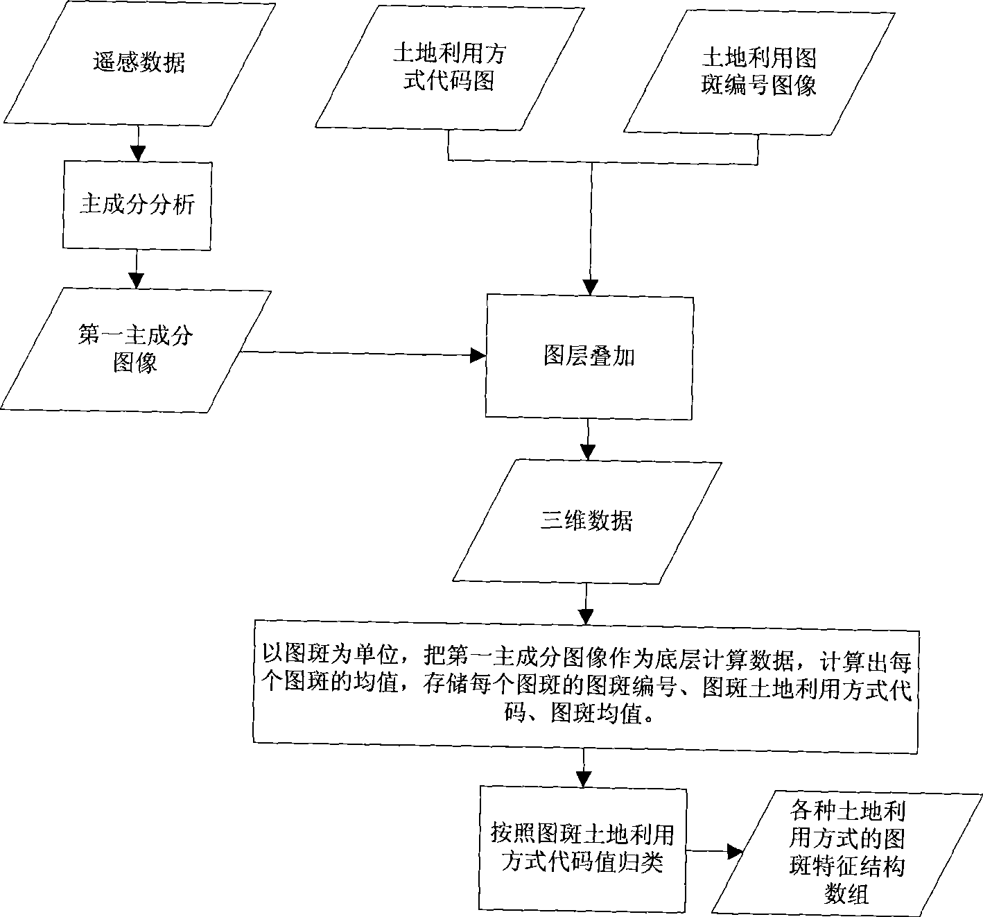
[0028] 2. Generate feature structure arrays of various land use patterns;

[0029] 3. Cycle mean significant statistical test change pattern;

[0030] 4. Change area supervised classification;

[0031] 5. Regional image merging;

[0032] The concrete realization process of the present invention is as figure 1 As shown, the specific implementation details of each part are as follows:

[0033] 1. Historical data preprocessing

[0034] Since the historical data used, that is, the old land use classification map, is raster data, in order to f...


PUM


Abstract

The invention relates to an automatic updating method of a land-use map based on historical data and remote sensed data. Firstly historical data is pre-processed to obtain a land-use patch number map and a land-use mode code map which are overlapped with a remote sensed image first main component map, and various land-use mode patch feature structure arrays are obtained through calculation; changed patches are detected by adopting a cycle average value significance statistical test method; land-use unchanged regions are used as the samples of land-use interest regions; and minimum distance supervised classification is performed to land-use changed regions to obtain the land-use maps of the changed regions, and the land-use maps of the changed regions are united with the images of and-use unchanged regions to obtain new land-use maps. The automatic updating method adopts two data sources, improves the variation test precision, realizes the updating automation of the land-use maps, can be applied to the departments of land and resources to update a great amount of land-use map data, quickly test the land-use variation, and has wide market prospect and application value.

Description


Claims


Application Information

Patent Timeline
Owner REMOTE SENSING APPLIED INST CHINESE ACAD OF SCI
Why Eureka
Try Eureka