Supercharge Your Innovation With Domain-Expert AI Agents!

Topographic data based ground proximity method and system thereof

A technology of terrain data and ground proximity warning, applied in the aviation field, can solve the problems of inability to understand the situation, limit the safety performance of the aircraft, and fail to issue warning signals in time, so as to reduce the incidence of accidents and improve the safety performance.

Active Publication Date: 2009-09-09
四川九洲空管科技有限责任公司
View PDF0 Cites 45 Cited by
  • Summary
  • Abstract
  • Description
  • Claims
  • Application Information

AI Technical Summary

Problems solved by technology

However, this traditional ground proximity warning system still has certain limitations, such as not being able to understand the situation ahead
Because it only has the function of "looking down" and depends on the radio altitude, and the radio altitude cannot reflect the terrain in front of the aircraft; it can assess whether there is danger ahead by tracking past flight information and predicting future flight information , but if there is a sudden rising terrain ahead, the warning signal cannot be issued in time; there is a "no warning" factor limitation, when the aircraft landing gear and flaps are in the landing configuration and descending at a normal speed, terrain warning cannot be provided; Thus limiting the improvement of aircraft safety performance

Method used


Image

  • Topographic data based ground proximity method and system thereof
  • Topographic data based ground proximity method and system thereof
  • Topographic data based ground proximity method and system thereof

Examples


Embodiment Construction

[0018] The technical solutions of the present invention will be described in further detail below with reference to the accompanying drawings and embodiments.

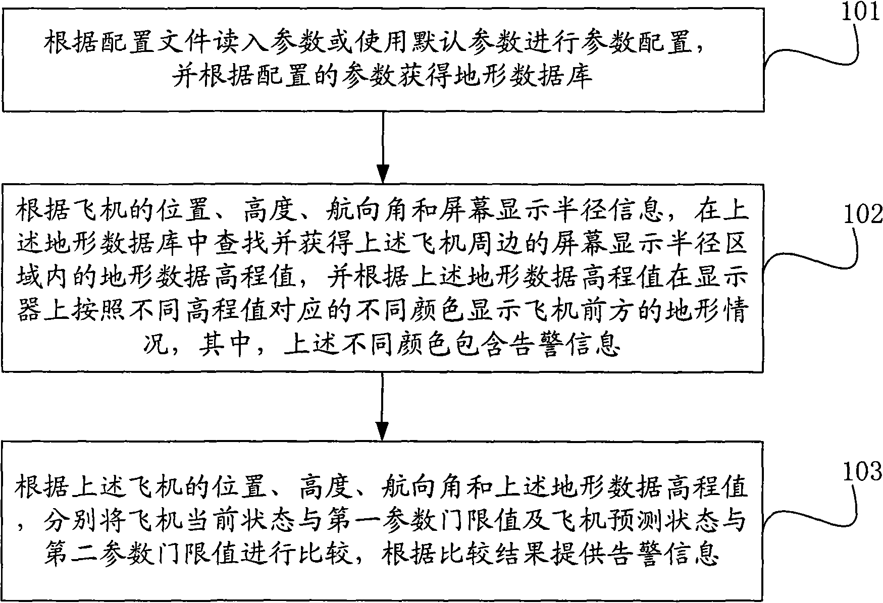
[0019] Such as figure 1 As shown, it is a flow chart of an embodiment of the ground proximity warning method based on terrain data in the present invention, and the method includes:

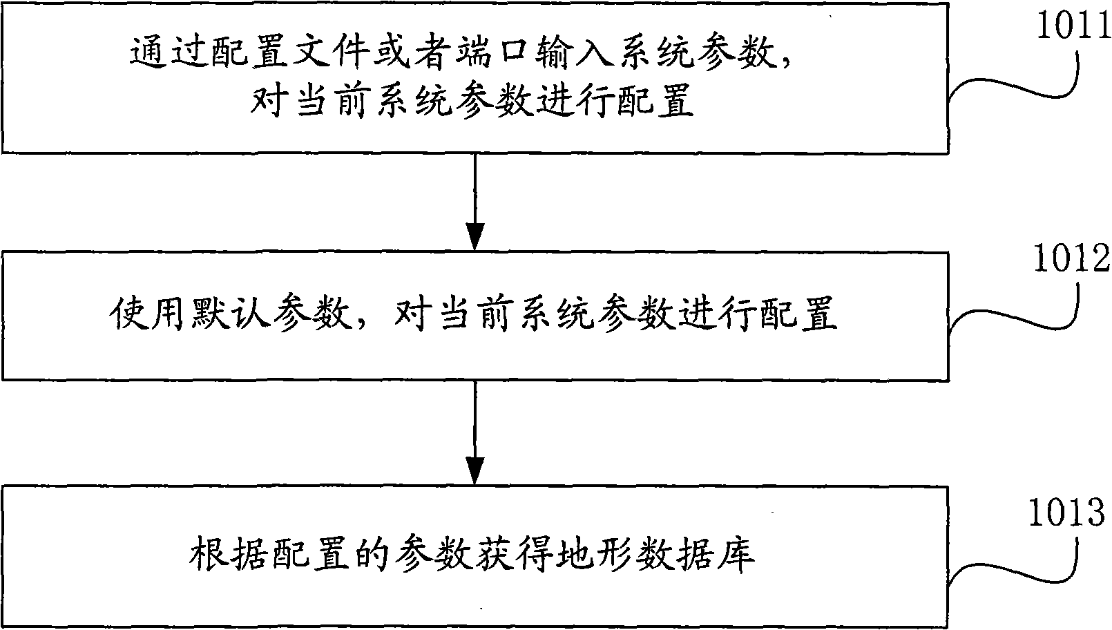
[0020] Step 101, read in the parameters according to the configuration file or use the default parameters to configure the parameters, and obtain the terrain database according to the configured parameters;

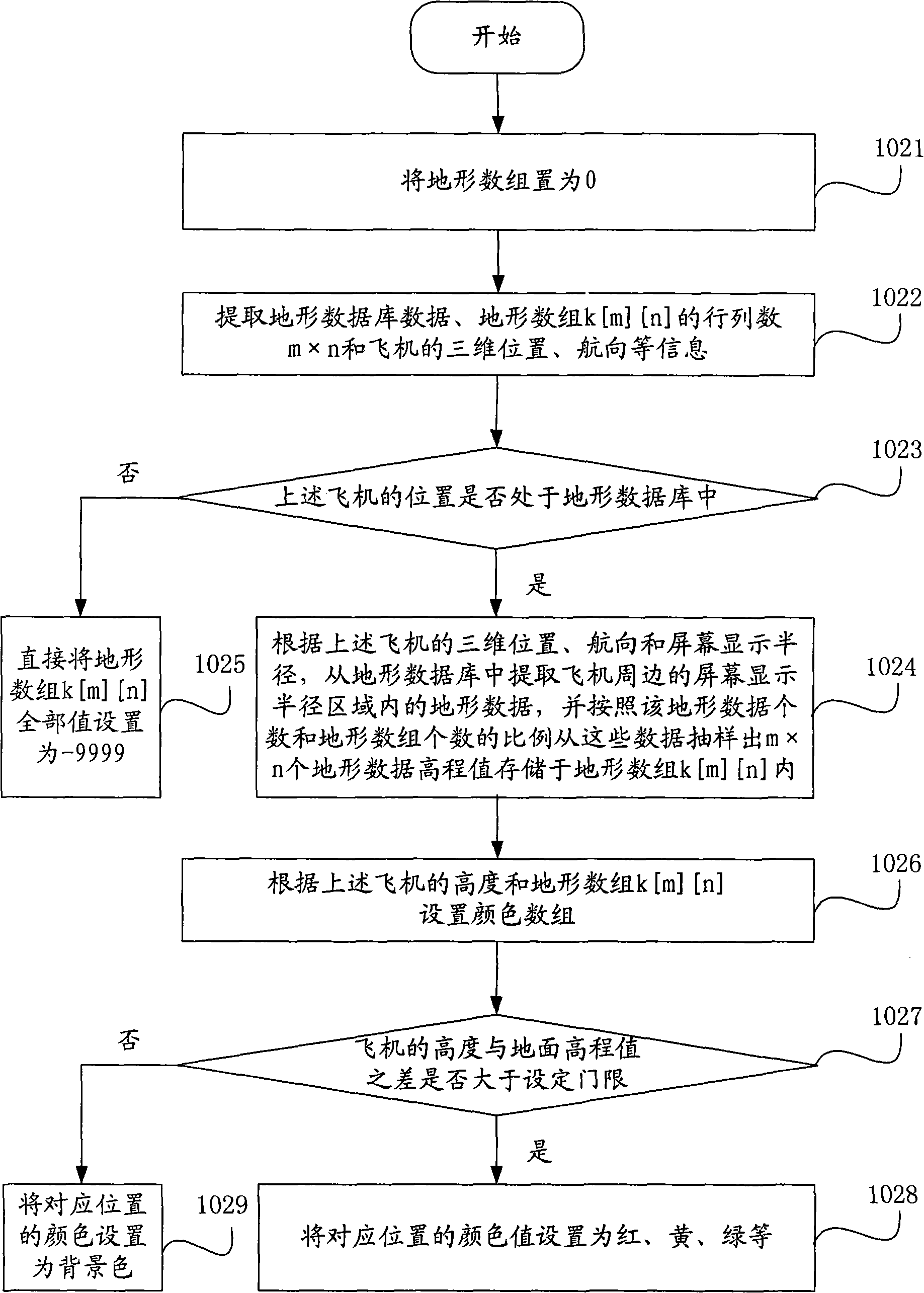
[0021] Step 102, according to the position, altitude, heading angle and screen display radius information of the aircraft, search and obtain the terrain data elevation value in the screen display radius area around the above-mentioned aircraft in the above-mentioned terrain database, and display the elevation value on the display according to the above-mentioned terrain data elevation value The terrain conditions in front of the air...


PUM


Abstract

The invention relates to a topographic data based ground proximity method and a system thereof; wherein, the topographic data based ground proximity method includes: reading in parameters according to a configuration document or using default parameters for parameter configuration and acquiring a topographic data according to the configuration data; searching and acquiring the altitude value of topographic data within the screen display semi-diameter area around the plane according to plane position, height, course angle and screen display semi-diameter information and displaying the topographic situation in front of the plane on the screen display according to different colors corresponding to the altitude values of topographic data. The topographic data based ground proximity method and the system acquires more comprehensive topographic data around the plane according to the altitude value of topographic data within the screen display semi-diameter area around the plane, thus reducing CFIT accident occurrence rate and improving the safety performance of the plane.

Description

technical field [0001] The invention relates to information processing technology, in particular to a ground proximity warning method and system based on terrain data; it belongs to the field of aviation technology. Background technique [0002] With the development of aviation technology, the safety requirements of aircraft are getting higher and higher. Air traffic control is an effective technology to make aircraft on the route safe, effective and planned to fly in the airspace. Among them, the ground proximity warning system (Ground Proximity Warning System, GPWS) is one of the important components of aircraft flight safety. It can be based on excessive descent speed, excessive near-ground rate; too small flaps lowered during take-off or go-around climb; too low altitude; when the aircraft approaches, the glide path deviates downward; wind shear and other conditions provide the pilot with Provide a warning message. [0003] GPWS can avoid controlled flight into terrain...

Claims


Application Information

Patent Timeline
IPC IPC(8): G08G5/04
Inventor 汪晓明刘志刚朱衍波肖玉项梅
Owner 四川九洲空管科技有限责任公司
Features
  • R&D
  • Intellectual Property
  • Life Sciences
  • Materials
  • Tech Scout
  • Unparalleled Data Quality
  • Higher Quality Content
  • 60% Fewer Hallucinations
Learn More