Satellite remote-sensing monitoring method of daytime marine fog

A technology of satellite remote sensing and sea fog, applied in the field of satellite remote sensing monitoring of sea fog during the day, can solve problems such as difficulty in promotion, few research on sea fog satellite monitoring, and no generality, and achieve the effect of reducing sea fog disasters

Inactive Publication Date: 2009-11-25
SECOND INST OF OCEANOGRAPHY MNR
View PDF0 Cites 28 Cited by
  • Summary
  • Abstract
  • Description
  • Claims
  • Application Information

AI Technical Summary

Problems solved by technology

Most of the thresholds determined by various threshold methods come from individual case studies at specific times and regions, so they are not general, making it difficult to popularize in application; moreover, most of these studies focus on the monitoring of land fog, and satellite monitoring research on sea fog is relatively less

Method used


Image

  • Satellite remote-sensing monitoring method of daytime marine fog
  • Satellite remote-sensing monitoring method of daytime marine fog
  • Satellite remote-sensing monitoring method of daytime marine fog

Examples


Embodiment Construction

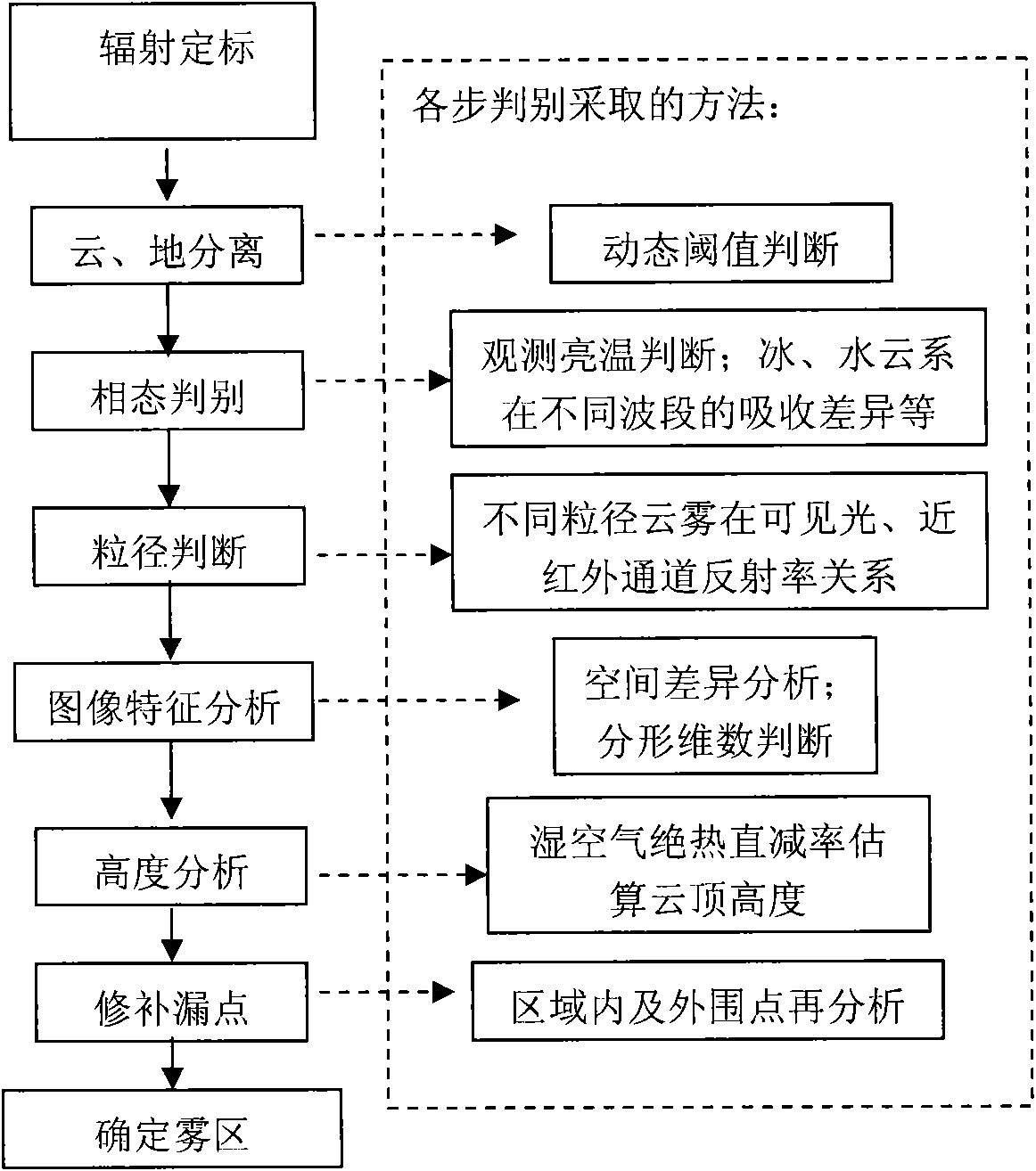
[0038] Below in conjunction with accompanying drawing, the present invention will be further described:

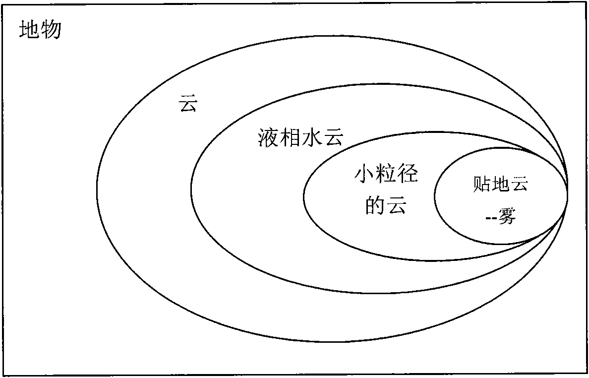
[0039] Sea fog can be defined as a kind of cloud close to the ground, in which a large number of tiny water droplets or ice crystals are suspended, making the ground visibility less than 1.0 km. Therefore, sea fog has the following characteristics: (1) it is a kind of cloud; (2) it exists in the form of liquid hydrometeor; (3) the particle size of fog droplets is relatively small; (4) the lower boundary is close to the ground, according to these feature, it is convenient to pass the location of the fog in the ground objects figure 1 In addition, on the satellite radiation image, the sea fog area has characteristics different from other cloud systems: the boundary is clear, the top of the sea fog is relatively uniform, and the texture is smooth.

[0040] According to the characteristics of the above-mentioned fog in ground objects and satellite images, the present inventio...


PUM


Abstract

This invention relates to application technical field of satellite remote-sensing data, specifically a satellite remote-sensing monitoring method of daytime marine fog. This invention gradually eliminates cloudless marine region, ice-phase cloud system, large-particle cloud system, top coarse cloud system and lower cloud system through steps as cloud-ground separation, phase discrimination, particle size judgment, image characteristic analysis, height analysis and error correction based on physical characteristics and image characteristics of marine fog and according to type of fog as ground object and satellite image characteristics, thereby realizing satellite remote-sensing monitoring of daytime marine fog. As for channel settings of AVHRR3/NOAA17 satellite, according to monitoring result acquired by performing long-term monitoring to the Yellow sea and the Bohai sea in China, it proves that this invention is able to effectively and automatically monitor marine fog events, and clearly provide influence covering range of marine fog, thereby providing meterorological information service to naval navigation, fisheries production and coastal domestic use. In addition, this invention is applicable to other satellite sensors with similar channel settings.

Description

technical field [0001] The invention belongs to the technical field of satellite remote sensing data processing and application, and in particular relates to a satellite remote sensing monitoring method for daytime sea fog. Background technique [0002] Sea fog is a phenomenon of water vapor condensation that occurs in the bottom layer of the atmospheric boundary on the ocean, and the vertical height is usually 200-500m. The occurrence of sea fog reduces the visibility of the sea surface, which has a serious impact on ship navigation, fishery production, coastal residents' life and military activities, often causing catastrophic accidents. Conventional meteorological monitoring of sea fog (manual or instrumental automatic observation by deploying stations on coasts or islands) is difficult to achieve on uninhabited oceans, especially large-scale monitoring. With the development of remote sensing technology and the improvement of sensor resolution, satellite remote sensing, ...

Claims


Application Information

Patent Timeline
Patent Type & Authority Applications(China)
IPC IPC(8): G01S17/00G06T7/00G01W1/00
Inventor 郝增周龚芳何贤强黄海清
Owner SECOND INST OF OCEANOGRAPHY MNR
Why Eureka
Try Eureka