Method and device for obtaining remotely sensed data based on grids

A remote sensing data and acquisition method technology, applied in the network field, can solve data security problems, increase the cost of remote sensing data resources, and the system cannot effectively integrate data resources, etc., to achieve the effect of solving security problems

Inactive Publication Date: 2010-05-05
CHINA AGRI UNIV
View PDF0 Cites 13 Cited by
  • Summary
  • Abstract
  • Description
  • Claims
  • Application Information

AI Technical Summary

Problems solved by technology

[0005] In the process of implementing the present invention, the inventors found that there are at least the following problems in the prior art: the way of sharing remote sensing data resources based on metadata will directly expose the data to the network when the data path is published on the network, and there are serious problems in data security. Big problem; the method of sharing remote sensing data resources based on Web services improves the operability of the remote sensing database system, but this type of system cannot effectively integrate various heterogeneous data resources; the method of sharing remote sensing data resources based on open systems In this way, users are required to install access software and host software at the same time, and they must run at the same time to complete the data interoperability process, which increases the cost of users sharing remote sensing data resources

Method used


Image

  • Method and device for obtaining remotely sensed data based on grids
  • Method and device for obtaining remotely sensed data based on grids
  • Method and device for obtaining remotely sensed data based on grids

Examples


Embodiment 1

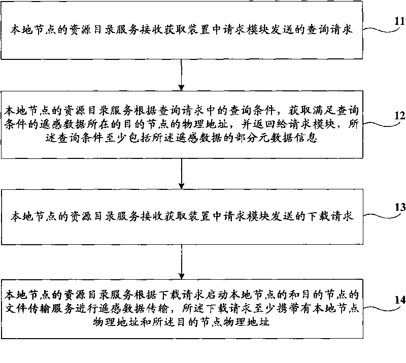
[0026] figure 1 It is a schematic flowchart of the grid-based remote sensing data acquisition method provided by Embodiment 1 of the present invention. The execution subject of this embodiment is the grid-based remote sensing data acquisition device on the local node, hereinafter referred to as the acquisition device, such as figure 1 As shown, the acquisition method provided in this embodiment includes the following steps:

[0027] Step 11, the resource directory service of the local node receives the query request sent by the request module in the acquisition device;

[0028] Step 12: According to the query condition in the query request, the resource directory service of the local node obtains the physical address of the destination node where the remote sensing data satisfying the query condition is located, and returns it to the requesting module. The query condition includes at least part of the remote sensing data metadata information;

[0029] Wherein, the request mo...

Embodiment 2

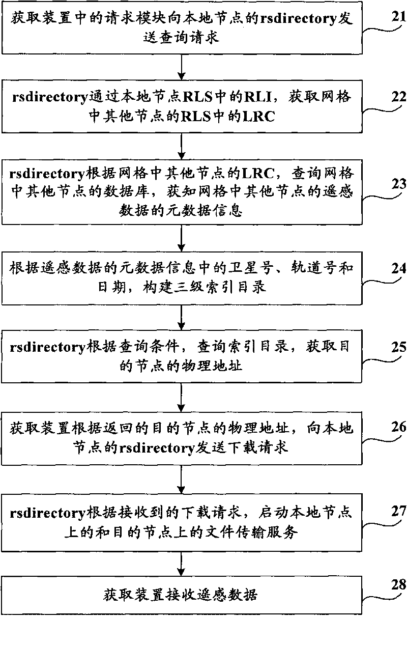
[0055] The specific implementation of the grid can be based on the software platform, and the grid middleware Globus Toolkit 4 is an open architecture and open standard project for building computer grids, and is an open source grid basic platform. Grid applications provide middleware services and libraries. At present, most grid projects are constructed based on the protocols and services provided by Globus Toolkit 4. Globus conducts research on key theories of grid computing such as resource management, security, information service and data management, and provides basic mechanisms and interfaces.

[0056] Based on the above technical solution, this embodiment takes the grid environment built based on Globus Toolkit 4 as an example to make a further description of the technical solution of the present invention. figure 2 It is a schematic flowchart of the grid-based remote sensing data acquisition method provided by Embodiment 2 of the present invention. The execution su...

Embodiment 3

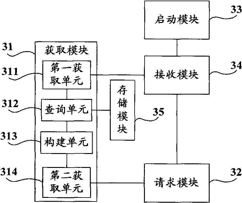
[0069] image 3 A schematic structural diagram of a device for acquiring grid-based remote sensing data provided by Embodiment 3 of the present invention. Such as image 3 As shown, the grid-based remote sensing data acquisition device provided in this embodiment, hereinafter referred to as the acquisition device, includes: an acquisition module 31 , a request module 32 , an activation module 33 and a reception module 34 . The specific working principle of the acquisition device is as follows:

[0070] The request module 32 in the obtaining device of the local node sends a query request to the receiving module 34, and the obtaining module 31 obtains other nodes in the grid through the replica index service in the replica location service of the local node according to the query request received by the receiving module 34 The local replica directory service in the replica location service accesses the database of the corresponding node through the obtained local replica direc...


PUM


Abstract

The invention provides a method and a device for obtaining remotely sensed data based on grids. The method comprises the following steps of: receiving an inquiring request sent by a request module through a source catalog service of a local node; according to inquiring conditions in the inquiring request, obtaining a physical address of a target node of the remotely sensed data meeting the inquiring conditions, and returning the physical address to the request module, wherein the inquiring conditions at least comprise part metadata information of the remotely sensed data; receiving a downloading request sent by the request module; and according to the downloading request, starting a document transmission service of the local node and the target node to transmit the remotely sensed data, wherein the downloading request at least carries the physical address of the local node and the physical address of the target node. The device comprises an obtaining module, a request module, a starting module and a receiving module. The invention provides the method and the device for obtaining the remotely sensed data based on grids, realizing the share of the remotely sensed data and simultaneously solving the problems of the safety, the heterogeneity and the distribution in the share process of the remotely sensed data.

Description

technical field [0001] Embodiments of the present invention relate to network technology, and in particular to a method and device for acquiring grid-based remote sensing data. Background technique [0002] As a basic spatial information resource, remote sensing data is widely used in various industries such as land resources, meteorology, environment, water conservancy, mining, and electric power. With the rapid development of aerospace technology, sensing technology, and database technology, the spatial resolution, spectral resolution, and time resolution of satellite remote sensing images have been greatly improved, and remote sensing data is growing at an alarming rate. The rapid growth of remote sensing data provides basic conditions for applied research in many fields, and provides new ways for people to analyze and solve problems. At the same time, its own characteristics have brought severe challenges to practical applications. [0003] The data types of remote sens...

Claims


Application Information

Patent Timeline
Patent Type & Authority Applications(China)
IPC IPC(8): G01S7/48H04L29/08G06F17/30
Inventor 高万林于丽娜杨克敏刘自力
Owner CHINA AGRI UNIV
Why Eureka
Try Eureka