Spatial variability layout plan generation method of heavy metal content in reclamation land soil

A technology of spatial variation and heavy metals, applied in soil material testing, special data processing applications, instruments, etc., can solve problems such as the influence of prediction results accuracy, the discount of prediction results accuracy, and the ambiguity of discussion.

Inactive Publication Date: 2010-06-02
SHANGHAI JIAO TONG UNIV
View PDF0 Cites 28 Cited by
  • Summary
  • Abstract
  • Description
  • Claims
  • Application Information

AI Technical Summary

Problems solved by technology

However, in terms of the selection of specific interpolation models, there is a lack of detailed analysis of spatial characteristics such as the spatial autocorrelation and anisotropy of soil sample observation data at sampling points, and the discussion on the determination process of the parameters involved in the selection of interpolation models is relatively vague. Greatly affect the accuracy and reliability of the prediction results of soil samples from unsampled points
On the other hand, the lack of sorting and screening of the interpolation process of large samples, especially the analysis and discussion of outliers and related processing, greatly reduces the accuracy of prediction results
[0004] After searching the existing technology, Liu Qing et al. published "Research on Spatial Distribution of Heavy Metals in Farmland Soil Based on GIS" in "Journal of Safety and Environment" (2007, 7(2): 109-113). Only logarithmic transformation is used above, and interpolation calculation is performed when the data conforms to the normal distribution and can satisfy the calculation of the variation function, and the spatial characteristics of the observed data of the soil samples at the sampling points are not analyzed in detail, so that the influence of the outlier value in the interpolation process is more significant, and the prediction The precision of the result will also be affected by

Method used


Image

  • Spatial variability layout plan generation method of heavy metal content in reclamation land soil
  • Spatial variability layout plan generation method of heavy metal content in reclamation land soil
  • Spatial variability layout plan generation method of heavy metal content in reclamation land soil

Examples


Embodiment 1

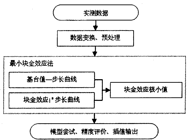
[0056] Embodiment 1: as figure 1 As shown, this implementation includes the following steps:

[0057] The first step is to obtain the content of heavy metal arsenic in the soil samples of the sampling points of the reclamation land in Chongming Island, Shanghai;

[0058] The second step is to perform data preprocessing on the heavy metal element content values ​​in the soil samples at the sampling points, and obtain the quasi-interpolation sub-samples of each soil heavy metal element respectively.

[0059] The data preprocessing refers to:

[0060] 2.1) Through the calculation and inspection of the skewed kurtosis of the content of heavy metal elements, check whether it meets the standard normal distribution condition H 0 , when it meets the standard normal distribution condition H 0 , proceed to the third step; otherwise, proceed to step 2.2.

[0061] The said standard normal distribution condition H 0 Refers to: the third moment of the content of heavy metal elements (g...

Embodiment 2

[0093] Embodiment 2: as figure 1 As shown, this embodiment includes the following steps:

[0094] The first step is to obtain the content of heavy metal copper in the soil samples of the sampling points of the reclamation land in the Chongming Island area of ​​Shanghai;

[0095] The second step, data preprocessing: the skew kurtosis test was carried out on the data of heavy metal copper in the soil samples of the sampling points. The test result is α=0.01 level, indicating that the standard normal distribution assumption is rejected, and then logarithmic transformation is performed on the data of the soil samples at the sampling points. After the transformation, the test is carried out, and the result still does not obey the normal distribution, and then the logarithmic transformation is performed twice, and the quasi-interpolation data is obtained after transformation.

[0096] The third step, exploratory spatial data analysis: by calculating the semivariogram between two p...


PUM


Abstract

The invention discloses a spatial variability layout plan generation method of heavy metal content in reclamation land soil, belonging to the technical field of environmental monitoring. The spatial variability layout plan generation method comprises: obtaining the soil sample of a sampling point in a reclamation land to be measured; carrying out data pretreatment to the numerical value of heavy metal content in the soil sample of a sampling point to respectively obtain the quasi-interpolation subsample of each soil heavy metal element; carrying out exploring spatial data analysis treatment to the quasi-interpolation subsample to obtain each anisotropy parameter, step length and step number of the soil sample of the sampling point; carrying out function fitting to the numerical value of heavy metal content in the soil sample of the sampling point to obtain a theoretical semi-variogram model suitable for obtaining heavy metal content interpolation; and drawing the spatial variability predicting result layout plan. The layout plan obtained by the invention can accurately evaluate the spatial condition of the heavy metal content in the reclamation land soil.

Description

technical field [0001] The invention relates to a method in the technical field of environmental monitoring, in particular to a method for generating a spatial variation distribution map of heavy metal content in soil of reclamation land. Background technique [0002] The soil of the reclamation land in Shanghai is saline soil, which is formed by the salt-salted silt under the joint action of rivers transporting sediment and seawater, as well as ocean currents, tides, waves and other factors, and is distributed in strips along the coast and estuary along the river The lot belongs to coastal saline soil type in terms of distribution and formation. This type of soil is highly alkaline, heavy in texture, low in organic matter, and high in salt. Due to the particularity of beach development, its spatial distribution is mainly affected by sewage outfalls, reclamation, tidal flat locations, and soil clay content. Not only does it vary greatly in space, but it also changes rapidly...

Claims


Application Information

Patent Timeline
Patent Type & Authority Applications(China)
IPC IPC(8): G01N33/24G06F19/00
Inventor 周培申广荣徐敬敬钱振华曹杰君
Owner SHANGHAI JIAO TONG UNIV
Why Eureka
Try Eureka