GPS maritime life-saving system

A GPS positioning and processing system technology, applied in the field of marine lifesaving systems, can solve the problems of unpopularity, use, and high power consumption

Inactive Publication Date: 2010-06-09
SHANGHAI JINGYI ELECTRICAL APPARATUS FACTORY CO LTD +1
View PDF0 Cites 18 Cited by
  • Summary
  • Abstract
  • Description
  • Claims
  • Application Information

AI Technical Summary

Problems solved by technology

The reason is that it is relatively large in size, heavy in weight, and consumes a lot of power.
No matter which one is now, the price is relatively expensive, so it cannot be popularized.
Existing personal GPS positioning systems can only be used within the range covered by GPRS, GSM,...

Method used


Image

  • GPS maritime life-saving system
  • GPS maritime life-saving system
  • GPS maritime life-saving system

Examples


Embodiment 1

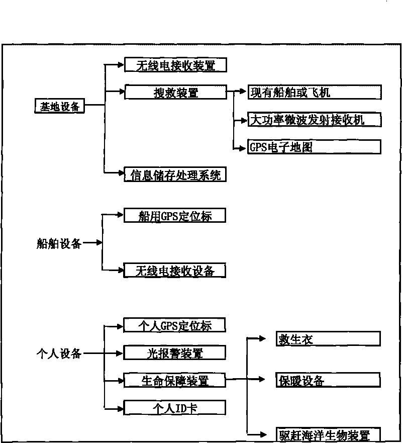
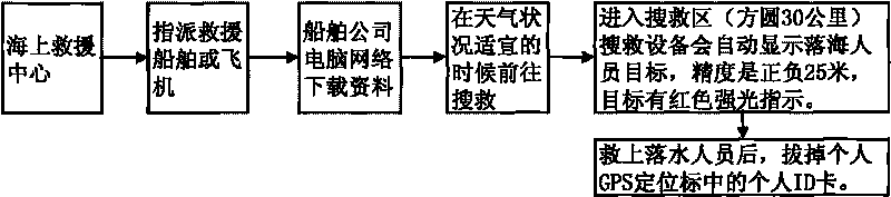
[0019] Such as figure 1 As shown, the GPS marine lifesaving system includes base equipment, ship equipment and personal equipment. The base equipment is equipped with a radio receiving device, an information storage and processing system, and a search and rescue device. The search and rescue device includes a search and rescue ship or aircraft. The search and rescue device is Set high-power microwave transmitting receiver and GPS electronic map on existing ship or aircraft, after the individual falls into the sea, when the search and rescue equipment is within the range of the scene of the accident (half longitude 30 kilometers). After the high-power microwave transmitter receiver receives the distress signal and position signal, the search and rescue equipment will automatically display the target of the person falling into the sea on the GPS electronic map, and at the same time retrieve the corresponding information from the information storage and processing system to go to ...


PUM


Abstract

The invention relates to a GPS maritime life-saving system which comprises a base device, a ship device and an individual device, wherein the base device is provided with a wireless receiver; the ship device is provided with a ship GPS localizer and a wireless receiving device; and the individual device comprises an individual GPS localizer and a light alarm device. When a maritime incidence happens, the ship GPS localizer on the ship device sends out a distress signal and a position signal, and after the wireless receiver of the base device receives the distress signal and the position signal, the rescuer goes to rescue. After a person falls into the sea, when a search and rescue device is within the range (30 km of radius) of the accident site, the GPS localizer on the individual device is immediately triggered to send out the distress signal and the position signal. Compared with the prior art, the invention has the characteristics of high safety and reliability, accurate positioning and the like, and can quickly rescue the person falling into the sea.

Description

technical field [0001] The invention relates to a marine lifesaving system, in particular to a GPS marine lifesaving system. Background technique [0002] At present, the GPS positioning system has been applied to the global positioning of automobiles, ships, and specific objects. It is also applied to terrestrial personal GPS global positioning, but it is limited to the range covered by mobile phone signals. There are also vehicle-mounted short-wave GPS positioning, military vehicle-mounted short-wave GPS positioning, and military microwave individual GPS global positioning. These include remote alarm and distress functions. Although it is widely used, it is rarely used in disaster relief and field operations. The reason is that it is relatively large in size, heavy in weight, and consumes a lot of power. No matter which one is now, the price is relatively expensive, so it cannot be popularized. Existing personal GPS positioning systems can only be used in areas covered...

Claims


Application Information

Patent Timeline
IPC IPC(8): B63B45/00G01S5/02G01S1/02B63C9/00B63C9/20B63C9/01
Inventor 刘光华李风波刘鼎红张重清卢慧坚徐正阳
Owner SHANGHAI JINGYI ELECTRICAL APPARATUS FACTORY CO LTD
Why Eureka
Try Eureka