
GPS floating vehicle-based traffic data fault identification and recovery method

A technology of fault identification and traffic data, applied in the field of intelligent transportation, to achieve reliable decision support, eliminate influence, and improve quality

Inactive Publication Date: 2010-06-16
JILIN UNIV
View PDF0 Cites 29 Cited by
  • Summary
  • Abstract
  • Description
  • Claims
  • Application Information

AI Technical Summary

Problems solved by technology

Most of the ILS estimation methods only consider how to use GPS and GIS data to reproduce the running process of the vehicle, so as to obtain the average speed of the vehicle passing through the road section or the total time consumed, and use these ILS data directly for the calculation of ALS measured data, while ignoring the Influence of individual characteristics of single vehicle operation on data quality
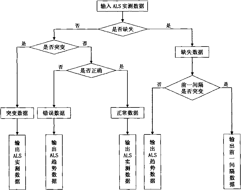
Most ALS estimation methods only judge whether the measured data is missing, and choose to output the measured data or historical trend data based on the judgment results, while ignoring the impact of random factors related to the traffic environment on data quality

Method used


Image

  • GPS floating vehicle-based traffic data fault identification and recovery method
  • GPS floating vehicle-based traffic data fault identification and recovery method
  • GPS floating vehicle-based traffic data fault identification and recovery method

Examples


Embodiment Construction

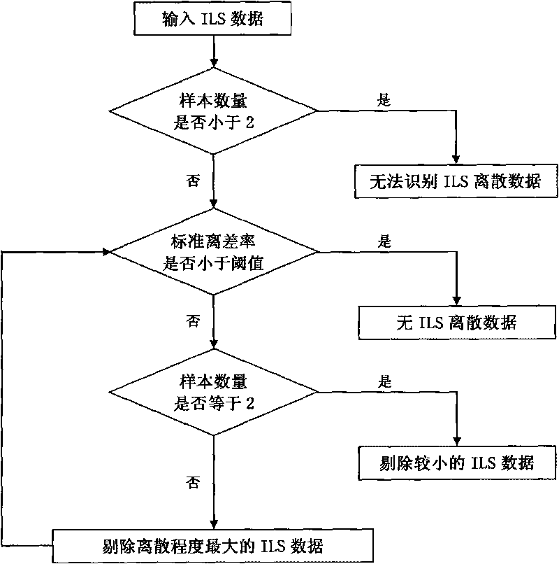
[0016] 1) The fault identification index of traffic data is a measure that reflects the quality of traffic data. Determining a reasonable identification index is a prerequisite for fault identification and repair of traffic data. For the characteristics of each ILS data and the relationship between all ILS data in any data analysis time interval (the time interval between two adjacent calculations of ALS measured data), the present invention selects validity and discreteness as the fault identification of ILS data Indicators, that is, to identify the validity and discreteness of the ILS data respectively. Through the GPS system of the floating car, the parking duration of the vehicle is obtained, combined with the timing data of the intersection control signal device, the speed and driving distance data of the vehicle are obtained, and the data is sent to the computer processor of the traffic command center through the signal transmission device for the single-vehicle road trip...


PUM


Abstract

The invention discloses a GPS floating vehicle-based traffic data fault identification and recovery method, which relates to a traffic information processing method. In the method, the shutdown condition of a floating vehicle is identified in real time to obtain the continuous shutdown time of the vehicle; in combination with intersection control signal timing data, the validity of the single road section travel speed data of the vehicle is identified; and the discreteness and discontinuity of the single road section travel speed data of the vehicle are identified through the real-time judgment of a processor of a computer to recover missing data so that the accuracy of the single road section travel speed data of the vehicle is identified.

Description

technical field [0001] The invention relates to traffic information collection and processing technology in the field of intelligent traffic, in particular to a GPS floating vehicle-based traffic data fault identification and repair method serving a traffic guidance system and a traffic state identification system. Background technique [0002] Travel speed, as the most intuitive traffic parameter reflecting the degree of road congestion, has always been highly valued by traffic management and control departments. The accuracy, timeliness and integrity of travel speed data directly affect the application effect of dynamic traffic management measures. Therefore, obtaining accurate, real-time and sufficient travel speed data is one of the important purposes of traffic information collection technology research. [0003] As the main means of travel speed acquisition, GPS floating vehicle has the advantages of short construction period and wide coverage, and it is convenient to...

Claims


Application Information

Patent Timeline
Patent Type & Authority Applications(China)
IPC IPC(8): G08G1/01G08G1/052
Inventor 姜桂艳常安德李琦牛世峰吴正言杨兆升张玮李继伟张伟李明涛李红伟姜卉张春勤孟志强唐勇勇
Owner JILIN UNIV
Learn More