WebGIS irrigation area management method of shared data and realization system thereof

A technology for sharing data and irrigation areas, applied in the field of computer information, can solve the problem that the spatial data of irrigation areas cannot be shared

Inactive Publication Date: 2010-09-08
CHINA AGRI UNIV
View PDF4 Cites 30 Cited by
  • Summary
  • Abstract
  • Description
  • Claims
  • Application Information

AI Technical Summary

Problems solved by technology

[0007] The technical problem to be solved by the present invention is to overcome the defect that the existing irrigation district spatial data cannot be shared

Method used


Image

  • WebGIS irrigation area management method of shared data and realization system thereof
  • WebGIS irrigation area management method of shared data and realization system thereof
  • WebGIS irrigation area management method of shared data and realization system thereof

Examples


Embodiment Construction

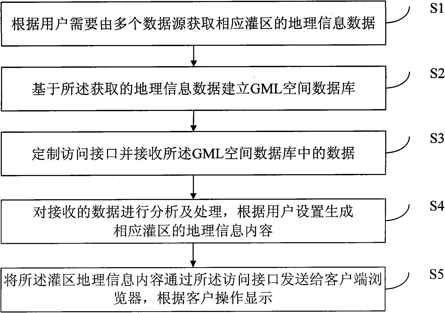
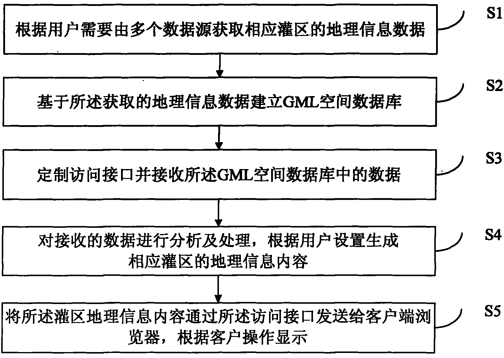
[0037] The WebGIS irrigation area management method and system for sharing data proposed by the present invention are described as follows in conjunction with the accompanying drawings and embodiments. The following examples are used to illustrate the present invention, but are not intended to limit the scope of the present invention.

[0038] like figure 1 Shown, the WebGIS irrigation area management method of shared data of the present invention comprises the following steps:

[0039] S1: Obtain the geographical information data of the corresponding irrigation area from multiple geographical data sources according to user input instructions. Among them, the geographical data sources include existing traditional GIS databases and Internet electronic map websites; the format of traditional GIS database spatial data is relatively complicated, and each All kinds of GIS products have their own data formats, and Shapefiles and MIF formats are commonly used; for Internet electroni...


PUM


Abstract

The invention discloses a WebGIS irrigation area management method of shared data, which comprises the following steps of: obtaining the geographic information data of the corresponding irrigation areas by a plurality of data sources according to the requirement of a user; constructing a GML spatial database based on the obtained geographic information data according to a preset GML spatial data sharing model; customizing an access interface for a WebGIS server according to the GML spatial data sharing model and receiving data in the GML spatial database by the interface; analyzing and processing the received data and generating the geographic information contents of the corresponding irrigation areas according to the setting of the user; and transmitting the geographic information contents of the irrigation areas to a client browser by the access interface and displaying according to the operation of a client. The invention also discloses a system for realizing the method. By the invention, the spatial data of the irrigation areas can realize cross-platform sharing by a unified interface, and a technical basis is provided for the large-scale popularization of WebGIS in the field of the irrigation management of the irrigation areas.

Description

technical field [0001] The invention relates to the field of computer information technology, in particular to a management method of a network geographic information system with open and shared geographic data sources and an implementation system thereof. Background technique [0002] At present, the informatization level of the management of large-scale irrigation areas in my country is still at a relatively low level. There are few points for collecting information in irrigation areas, and the means of observation are relatively simple. The information is transmitted through telephone line analog signals or manual paper media, and it is impossible to accurately monitor various water areas in irrigation areas in real time. Item characteristic index information. Therefore, irrigation districts cannot dynamically adjust water use plans, and water use scheduling is mostly based on experience, which cannot adapt to changes in water regimes and crop planting structures, and inev...

Claims


Application Information

Patent Timeline
Patent Type & Authority Applications(China)
IPC IPC(8): G06Q10/00G06Q50/00G06F17/30
Inventor 高万林朱益龙张树亮武斌赵佳宁左小苗
Owner CHINA AGRI UNIV
Why Eureka
Try Eureka