GPS/SINS (Global Positioning System/Strapdown Inertial Navigation System) based town cadastre map control point rapid measuring and off line data processing method

A technology of data processing and cadastral map, applied in the field of surveying and mapping, can solve the problems of GPS superiority not being well exerted, time-consuming and laborious layout of map root points, etc., to achieve the effect of improving efficiency and positioning accuracy, rapid layout, and free layout

Inactive Publication Date: 2012-11-28
SOUTHEAST UNIV
View PDF3 Cites 1 Cited by
  • Summary
  • Abstract
  • Description
  • Claims
  • Application Information

AI Technical Summary

Problems solved by technology

It can be seen that when the existing technology uses GPS-RTK for cadastral survey work, it is still subject to many restrictions. The superiority of GPS has not been well utilized, and the layout of map root points is still time-consuming and laborious.

Method used


Image

  • GPS/SINS (Global Positioning System/Strapdown Inertial Navigation System) based town cadastre map control point rapid measuring and off line data processing method
  • GPS/SINS (Global Positioning System/Strapdown Inertial Navigation System) based town cadastre map control point rapid measuring and off line data processing method
  • GPS/SINS (Global Positioning System/Strapdown Inertial Navigation System) based town cadastre map control point rapid measuring and off line data processing method

Examples


Embodiment Construction

[0029] Below in conjunction with accompanying drawing, the working principle of the present invention and embodiment will be further described:

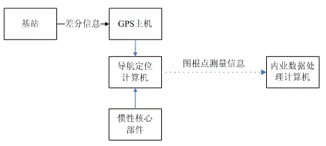
[0030] The inertial core components of the strapdown inertial navigation system in this embodiment are composed of a fiber optic gyroscope (FOG) and a quartz flexible accelerometer. The navigation and positioning computer selects PC / 104 industrial computer, and the coordinates of known points measured by GPS-RTK are transmitted to the navigation The transmission mode of the positioning computer is serial port input.

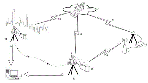
[0031] figure 1 It is the device connection and working principle diagram of the present invention. Explanation of symbols: 1. GPS constellation, 2. GPS signal, 3. base station antenna, 4. base station host, 5. data link, 6. differential signal sent from base station to mobile station, 7. rover GPS host, 8. rover Antenna, 9. Inertial core components, 10. Navigation and positioning computer, 11. Indexing device, 12. O...


PUM


Abstract

The invention discloses a GPS / SINS (Global Positioning System / Strapdown Inertial Navigation System) based town cadastre map control point rapid measuring and off line data processing method, which comprises the steps of: distributing map control points in a region with unstable GPS signals by using GPS / SINS town cadastre map control point measuring equipment according to first net information, obtaining initial information of the work of the GPS / SINS town cadastre map control point measuring equipment by using the known control points and the special transposition operation through the GPS / SINS town cadastre map control point measuring equipment to form a navigation positioning coordinate system; obtaining coordinates of the map control points in a hiding region by using the GPS / SINS towncadastre map control point measuring equipment in a process of distributing the map control points; and integrating stored measured data of an inertia core part in the external operation with the GPSinformation by using off line data processing software, realizing high-precision positioning of the map control points in the region with unstable GPS signals and evaluating the positioning precision. The invention can favorably improve the efficiency of distributing the map control points and the positioning precision.

Description

technical field [0001] The present invention relates to measurement, surveying and mapping technology and inertial navigation positioning and orientation technology, in particular to a GPS / SINS-based urban cadastral map root point rapid measurement and post-event data processing method that utilizes GPS and SINS to coordinate map root point layout in the process of urban cadastral surveying and mapping , belonging to the field of surveying and mapping technology. Background technique [0002] With the rapid development of my country's national economy, it is urgent to find out the real estate of urban land and provide detailed data support for the planning and decision-making of government departments. At present, my country's urban cadastral survey is still using GPS and total stations to complete the control survey, and the urban cadastral data in my country has huge changes, so an efficient urban cadastral survey method using high-tech technology is needed to ensure urban...

Claims


Application Information

Patent Timeline
Patent Type & Authority Patents(China)
IPC IPC(8): G01S19/42G01C21/18
Inventor 王宇吴峻王庆
Owner SOUTHEAST UNIV
Why Eureka
Try Eureka