
Navigation method and navigator

A navigation method and navigator technology, applied in the field of navigation, can solve problems such as not adjusting the data itself

Inactive Publication Date: 2011-07-20
CLARION CO LTD
View PDF7 Cites 10 Cited by
  • Summary
  • Abstract
  • Description
  • Claims
  • Application Information

AI Technical Summary

Problems solved by technology

This method only adjusts the priority of the data used for calculation, and does not adjust the data itself

Method used


Image

  • Navigation method and navigator
  • Navigation method and navigator
  • Navigation method and navigator

Examples


Embodiment Construction

[0051] The preferred embodiments of the present invention will be described in detail below with reference to the accompanying drawings, and unnecessary details and functions for the present invention will be omitted during the description to prevent confusion in the understanding of the present invention.

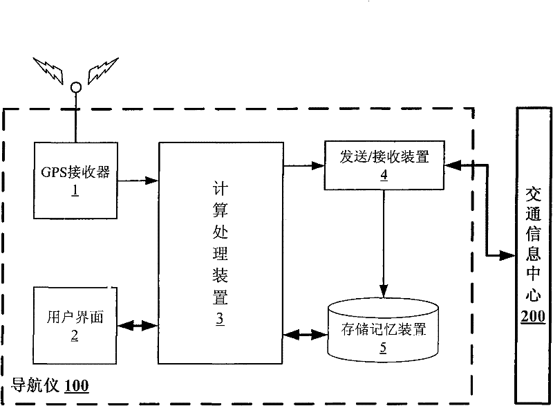
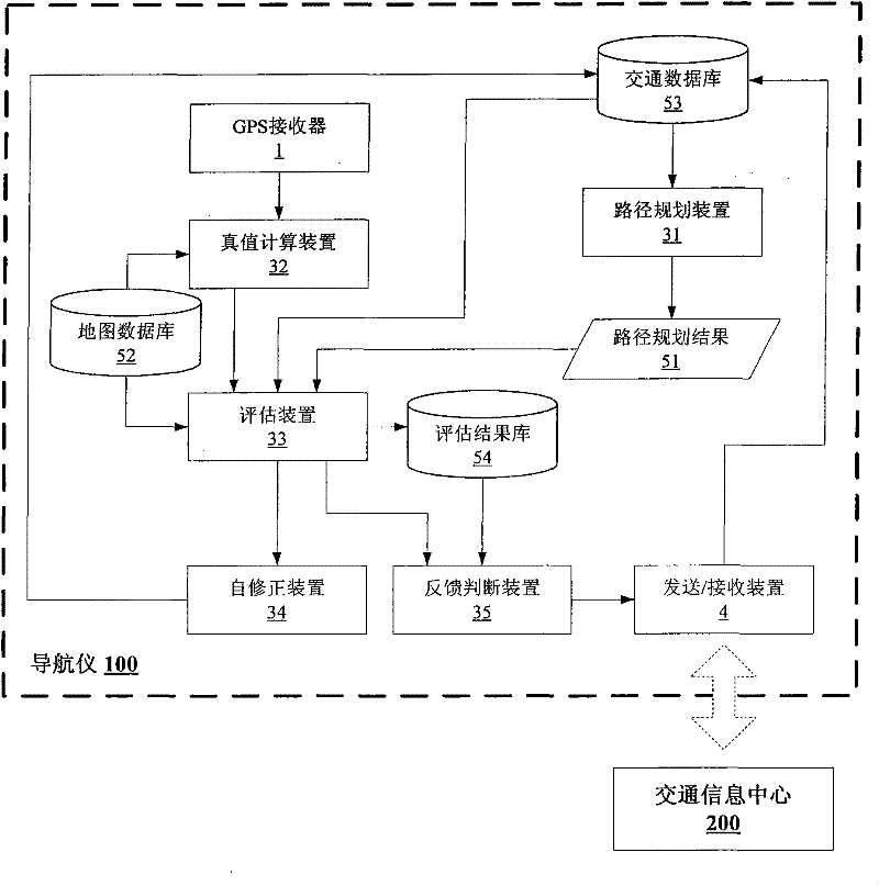
[0052] figure 1 is a structural schematic diagram of the navigator 100 of the present invention. The navigator 100 of the present invention may include: a GPS receiver 1 , a user interface 2 , a calculation processing device 3 , a sending / receiving device 4 and a storage memory device 5 . Among them, the GPS receiver 1 is used to collect the current location information of the vehicle. The user interface 2 is used to receive instructions from the user, such as the input of the start point and the end point, and display information such as the result of the route planning of the navigator and the current position of the vehicle. The main function of the calculation proces...


PUM


Abstract

The invention provides a navigation method for automatically evaluating and adjusting navigation data. A navigator comprises a memory device, a sending / receiving device, a positioning information receiver, a user interface and a calculating device, wherein the memory device is used for storing multiple kinds of data required when other devices of the navigator perform processing; the sending / receiving device is used for communicating with a navigation server and storing multiple kinds of received data in the memory device; the positioning information receiver is used for receiving the current time and the current position information in real time and storing the current time and the current position information in the memory device; the user interface is used for receiving information input by a user and displaying a planning path and the current position of the navigator; and the calculating device is used for replanning a path according to the current latest estimated travel time received from the navigation server by taking the current position as a starting point when an error between real travel time calculated according to the information acquired by the positioning information receiver in real time and stored estimated travel time used during planning is greater than a predetermined threshold value.

Description

technical field [0001] The invention relates to the field of navigation, in particular to a navigation method and a navigator capable of automatically evaluating and adjusting navigation data. Background technique [0002] In order to improve the accuracy of route planning results, in addition to using some static data in the electronic map for route planning, the navigator also needs to use the real-time estimated traffic data sent by the traffic information service center. However, inevitably, there will be errors between these estimated data and actual traffic data, so that the travel time calculated by the navigator is still not accurate enough, and sometimes the error is relatively large. Therefore, the present invention hopes that the navigator can also collect real-time traffic data while navigating for the driver, and use the collected data as the true value to evaluate the estimated traffic data, and the result of the evaluation can be used for the navigator It can...

Claims


Application Information

Patent Timeline
IPC IPC(8): G01C21/34
Inventor 山根宪一郎李曼王文佳
Owner CLARION CO LTD
Learn More