Multi-hypothesis map matching method based on vehicle state transition

A map matching and state transfer technology, applied in the field of map matching

Inactive Publication Date: 2011-09-07
WUXI RES INST OF APPLIED TECH TSINGHUA UNIV +1
View PDF5 Cites 15 Cited by
  • Summary
  • Abstract
  • Description
  • Claims
  • Application Information

AI Technical Summary

Problems solved by technology

[0007] The technical problem to be solved by the present invention is: how to accurately record the continuous path traveled by the car, and at the same time obta

Method used


Image

  • Multi-hypothesis map matching method based on vehicle state transition
  • Multi-hypothesis map matching method based on vehicle state transition
  • Multi-hypothesis map matching method based on vehicle state transition

Examples


Embodiment Construction

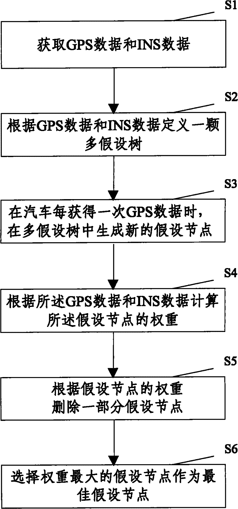
[0054] The specific implementation manners of the present invention will be described in further detail below in conjunction with the accompanying drawings and examples. The following examples are used to illustrate the present invention, but are not intended to limit the scope of the present invention.

[0055] Such as figure 2 Shown, method of the present invention comprises the following steps:

[0056] S1. Acquire GPS data from the global positioning system and INS data from the inertial navigation system;

[0057] S2. Define a multi-hypothesis tree according to GPS data and INS data (hereinafter referred to as GPS / INS data), and the definition of the multi-hypothesis tree is as follows:

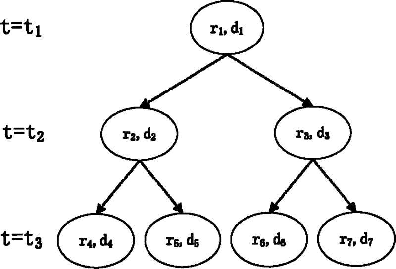
[0058] The multi-hypothesis tree is a tree (such as figure 1 as shown, figure 1 Among them, r1~r7 represent the route, d1~d7 represent the driving direction of the car on this route);

[0059]The tree has only one root node (the root node, the node represented by r1 and d1), which ...


PUM


Abstract

The invention discloses a multi-hypothesis map matching method based on vehicle state transition, comprising the following steps of: S1, obtaining GPS (global positioning system) data and INS (inertial navigation system) data; S2, defining a multi-hypothesis tree according to the GPS data and the INS data, wherein the multi-hypothesis tree is used for recording all traveled paths of a vehicle, a root node is in the multi-hypothesis tree, and the root node represents a start point of the vehicle; S3, generating new hypothesis nodes in the multi-hypothesis tree when the vehicle obtains the GPS data each time; S4, calculating weight of the hypothesis nodes according to the GPS data and the INS data, wherein the weight indicates the similarity of the information included in the hypothesis nodes to the real information; S5, deleting some hypothesis nodes according to the weight of the hypothesis nodes; S6, selecting the hypothesis node with largest weight as the optimal hypothesis node. The multi-hypothesis map matching method based on the vehicle state transition can record the continuous traveled path of the vehicle, and also can get better matching result under the condition that GPS signal quality is not good or the vehicle is in a region where roads are intensive.

Description

technical field [0001] The invention relates to the field of map matching, in particular to a multi-hypothesis map matching method that utilizes vehicle state transition information to limit generation of hypothetical nodes, and the method can be used to match paths traveled by cars. Background technique [0002] The map matching algorithm matches the GPS (Global Positioning System, Global Positioning System) / INS (Inertial Navigation System, inertial navigation system) data with the electronic map data to find out the position of the car in the electronic map. Map matching algorithm is mainly used in car navigation, recording car running track and so on. [0003] From the end of the 20th century to the present, there have been many map matching algorithms, including map matching algorithms based on position point matching, map matching algorithms based on area method criteria, fuzzy logic algorithms, curve fitting algorithms, etc. [0004] These algorithms have achieved ver...

Claims


Application Information

Patent Timeline
IPC IPC(8): G01C21/30
Inventor 王道顺贺志宏刘松高达刘澍董琳戴良光赵明国石宗英
Owner WUXI RES INST OF APPLIED TECH TSINGHUA UNIV
Why Eureka
Try Eureka