System time offset-aided multimode satellite navigation method

A multi-mode satellite and system time technology, applied in the field of satellite navigation, can solve problems such as unreasonable geometric precision factor, performance degradation of user-level processing methods, and increased geometric precision factor

Inactive Publication Date: 2011-09-07
NAT TIME SERVICE CENT CHINESE ACAD OF SCI
View PDF3 Cites 4 Cited by
  • Summary
  • Abstract
  • Description
  • Claims
  • Application Information

AI Technical Summary

Problems solved by technology

[0053] For the user-level processing method, the system time difference is regarded as an unknown solution. In this way, every time a system is added, the minimum number of observation satellites required for positioning solution will increase by one. In an open environment, this is easy to meet, but in a multi-occlusion environment, This condition may not necessarily be satisfied
In addition, in a m...

Method used


Image

  • System time offset-aided multimode satellite navigation method
  • System time offset-aided multimode satellite navigation method
  • System time offset-aided multimode satellite navigation method

Examples


Embodiment 1

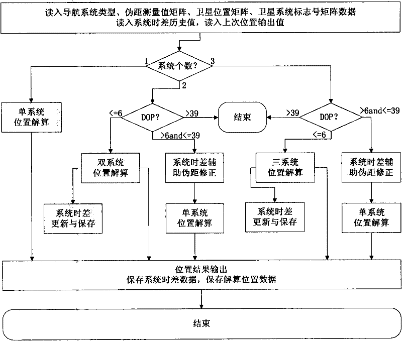
[0071] figure 2 It is the overall design of the system time deviation assisted multi-mode satellite navigation method of the present invention.

[0072] Step A1, start the algorithm, input the measurement time, read in the navigation system type, pseudo-range measurement value matrix, satellite position matrix, and read in the system time difference history value and the last calculated position output value from the file saved in the last run of the program .

[0073] Step A2, judging the number of systems;

[0074] If there is only one system, set the time difference correction flag to 1, enter the single system calculation process, calculate the receiver position according to the linear iterative method, and output the position result.

[0075] If there are two systems participating in the calculation, enter the dual system calculation process; according to the dual system calculation rules, first calculate the DOP value, and perform corresponding operations according to...

Embodiment 2

[0078] Embodiment 2: Analysis of system time deviation assisted navigation method

[0079] The main contribution of the system time difference assisted navigation method is to increase the judgment of the DOP value. When the DOP value is reasonable, the system time difference is calculated. When the DOP value is greater than 6, the observation conditions are poor, and the extrapolated value of the system time difference is used as the current system time difference. The difference, the number of unknowns that need to be solved currently is reduced, and the geometric precision factor is optimized by reducing the number of unknowns to be solved to improve the positioning accuracy.

[0080] The feasibility of this method mainly focuses on two aspects: 1) whether the receiver has time to receive enough satellites in a multi-occlusion environment; 2) whether the accuracy of the receiver's time difference extrapolation for the autonomous system can meet the system requirements.

[0...


PUM


Abstract

The invention discloses a system time offset-aided multimode satellite navigation method. The method comprises the following steps: (A1) starting an algorithm, inputting a measurement time, reading the type of a navigation system, a pseudo range measurement value matrix and a satellite position matrix, and reading the historical value of a system time difference and the output value of the previous solution position from a file stored during the previous running of the program; (A2) determining the number of the systems, setting a time difference correction mark as 1 if the number of the system is 1, entering a singe-system solution process, resolving the position of a receiver according to the linear iteration method and outputting the position result; entering a double-system solution process if two systems participate in the solution; and entering a three-system solution process if three systems participate in the solution and if the DOP (dilution of precision) value is smaller than and equal to 6; and (A3) outputting the solved position result, and storing the updated historical value of the system time difference and the output position of the current solution for the subsequent program running.

Description

technical field [0001] The invention relates to the technical field of satellite navigation, in particular to a system time deviation assisted multi-mode satellite navigation method. Background technique [0002] Multi-mode satellite navigation technology refers to the combination of two or more satellite navigation systems in an appropriate way, using their complementary characteristics in performance to obtain higher navigation performance than using any system alone. [0003] The concept of multi-mode satellite navigation has already appeared during the construction of GPS and GLONASS, but it has not been fully developed until the construction of Galileo system began, and multi-mode navigation has gradually been valued by people. And construction, multi-mode navigation will have more room for development. [0004] In multi-mode satellite navigation, because the system time of different satellite navigation systems is different, although they are all traced to Coordinated...

Claims


Application Information

Patent Timeline
IPC IPC(8): G01S19/33G01S19/35
Inventor 李孝辉许龙霞张慧君薛艳荣
Owner NAT TIME SERVICE CENT CHINESE ACAD OF SCI
Why Eureka
Try Eureka