
Guide label-based regional traffic directing server

A server and tag technology, applied in the directions of instruments, navigation, mapping and navigation, can solve the problems of difficult to navigate portals, shops, counters and office card slots, high terminal configuration, slow updating of geographic information, etc., to reduce the hardware configuration of the terminal. requirements, dynamic adjustment of traffic flow, the effect of low terminal configuration requirements

Inactive Publication Date: 2012-04-04
SOUTH CHINA UNIV OF TECH
View PDF6 Cites 3 Cited by
  • Summary
  • Abstract
  • Description
  • Claims
  • Application Information

AI Technical Summary

Problems solved by technology

[0013] (1) Signal strength limitation: GPS signal strength is affected by weather and buildings, especially in indoor and underground buildings where the GPS signal is weak;
[0014] (2) Navigation range limitation: GPS is more suitable for plane range navigation, but for internal navigation of multi-storey buildings, GPS sometimes indicates errors; and it is difficult to provide navigation such as "10 floors up the elevator" and "5 floors down the elevator";
[0015] (3) Navigation accuracy limitation: The signal accuracy of commercial GPS is limited, and it is difficult to navigate to specific portals, shops, counters and office card positions in dense commercial office areas;
[0016] (4) Equipment cost limitation: The built-in commercial GSP signal receiver in the terminal leads to an increase in the cost of terminal equipment;
[0017] (5) Restrictions on real-time update: Geographical information data is stored inside the terminal, which has a lag effect in updating;
[0018] (6) Dynamic adaptation limitation: When traffic congestion occurs on some lines in the region, managers lack the means to dynamically adjust the optimal line;
[0023] (3) High label cost: RFID readable and writable labels are required, and the cost is usually higher than that of barcode labels, QR code labels, and read-only labels, and there is cost pressure in high-density deployment;
[0024] (4) High terminal configuration: The terminal not only needs to save geographic information data, but also execute route planning, which requires strong computing power and storage capacity;
[0025] (5) Geographic information update is slow: the terminal saves geographic information data, and its update has a lag effect, and the latest geographic information changes are difficult to reach all terminals in real time;
[0026] (6) Lack of dynamic adaptability: when some lines in the area are congested, managers lack the means to dynamically adjust the optimal line;
[0027] (7) It is cumbersome to use: the user can only identify hop by hop and confirm the recognition operation one by one; only the information of the next hop label can be obtained each time, and the complete traffic guidance information cannot be returned at one time

Method used


Image

  • Guide label-based regional traffic directing server
  • Guide label-based regional traffic directing server
  • Guide label-based regional traffic directing server

Examples


Embodiment Construction

[0076] The present invention will be described in further detail below in conjunction with the embodiments and the accompanying drawings, but the embodiments of the present invention are not limited thereto.

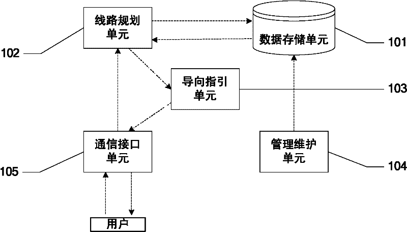
[0077] figure 1 A structural schematic diagram of the present invention is provided;

[0078] Such as figure 1 , the server configuration of an embodiment of the present invention includes: a data storage unit 101, used to store data required for route planning and guidance;

[0079] A route planning unit 102, configured to perform route planning and link merging operations;

[0080] A guide unit 103, configured to generate a guide based on the optimal route;

[0081] The management and maintenance unit 104 is used to create a mapping relationship between the guide label and the key position and the guide position, and save and maintain the data in the data storage unit;

[0082] A communication interface unit 105, configured to receive a guidance request through...


PUM


Abstract

The invention discloses a guide label-based regional traffic directing server which is characterized by comparing a data storage unit (1), a line planning unit (2), a guide directing unit (3), a management maintaining unit (4) and a communication interface unit (5). The server is used for building a guide network according to stored geographic information data and information such as a key position, a guide position, a usable route and the like; and ensuring a destination and the current guide position after a guide directing request is received, ensuring an optimal line from the current guide position to the destination based on the guide network by adopting a line planning algorithm, generating integrated guide direction, and feeding the integrated guide direction back to a guide terminal. By adopting the management maintaining unit, the server is used for offering a maintenance method to geographic information data, the guide network and link cost weight, so that the optimal line can be dynamically adjusted by a manager according to the condition of the regional traffic.

Description

technical field [0001] The invention relates to the field of traffic guidance, in particular to an area traffic guidance server based on guidance tags. Background technique [0002] Traffic guidance is a necessary service for people in production and daily life. [0003] The traditional personal traffic guidance method includes the following steps: [0004] (1) Select the destination; [0005] (2) Determine the current location; [0006] (3) Mark the starting point and destination point on the map; [0007] (4) Plan the optimal route according to the map; [0008] (5) Convert the optimal route into traffic guidance for the actual environment, including: go ahead 100 meters, turn left, turn right, etc. [0009] In addition, the demand for regional traffic guidance services includes: [0010] (6) Traffic guidance can reflect changes in geographic information in real time: such as route diversions, location changes, etc.; [0011] (7) Traffic guidance can dynamically ada...

Claims


Application Information

Patent Timeline
IPC IPC(8): G01C21/00G06K7/00
Inventor 黄松
Owner SOUTH CHINA UNIV OF TECH
Learn More