Parallel and adaptive matching method for acquiring remote sensing images with homogeneously-distributed matched points
An adaptive matching and remote sensing image technology, applied in image analysis, image data processing, instruments, etc., can solve problems such as complex calculations, and achieve the effect of strong application value
- Summary
- Abstract
- Description
- Claims
- Application Information
AI Technical Summary
Problems solved by technology
Method used
Image
Examples
Embodiment Construction
[0028] A preferred embodiment of the present invention is realized by the following steps:
[0029] The first step is to obtain the overlapping areas of remote sensing images to be matched. According to the metafile information of the remote sensing image, the geographical range of the remote sensing image is obtained, and then the geographical range of the two remote sensing images to be matched is compared to obtain the overlapping area, as shown in the attached figure 1 shown;
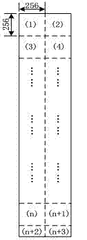
[0030] The second step is to divide the overlapping area into blocks. In the overlapping area, divide into blocks with a fixed size of 256×256 in order from left to right and from top to bottom, and divide the part of the overlapping area that is less than 256 rows (columns) at the end of the overlapping area into blocks according to the remaining size, as shown in the attached figure 2 shown;
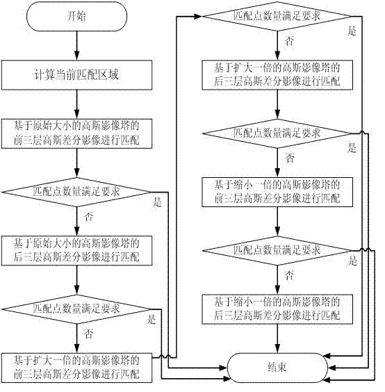
[0031] The third step is to use the SIFT algorithm to match each block in parallel. At this time, the...
PUM
 Abstract
Description
Claims
Application Information
 - R&D
- Intellectual Property
- Life Sciences
- Materials
- Tech Scout
- Unparalleled Data Quality
- Higher Quality Content
- 60% Fewer Hallucinations
Browse by: Latest US Patents, China's latest patents, Technical Efficacy Thesaurus, Application Domain, Technology Topic, Popular Technical Reports.
© 2025 PatSnap. All rights reserved.Legal|Privacy policy|Modern Slavery Act Transparency Statement|Sitemap|About US| Contact US: help@patsnap.com


