Azimuth information-based beyond-visual-range target geographic coordinate direct estimation method

A technology of geographic coordinates and azimuth information, used in positioning, measuring devices, instruments, etc., can solve the problems of limited over-the-horizon target positioning accuracy and signal-to-noise ratio threshold, and achieve improved target positioning accuracy, estimation accuracy, and calculation accuracy. efficient effect

Active Publication Date: 2019-02-01
PLA STRATEGIC SUPPORT FORCE INFORMATION ENG UNIV PLA SSF IEU
View PDF10 Cites 23 Cited by
  • Summary
  • Abstract
  • Description
  • Claims
  • Application Information

AI Technical Summary

Problems solved by technology

[0004] Aiming at the problems of limited positioning accuracy and signal-to-noise ratio threshold of over-the-horizon targets, the present invention provides a method for directly estimating the geographical coordinates of over-the-horizon targets based on azimuth information to improve the performance of over-the-horizon target positioning

Method used


Image

  • Azimuth information-based beyond-visual-range target geographic coordinate direct estimation method
  • Azimuth information-based beyond-visual-range target geographic coordinate direct estimation method
  • Azimuth information-based beyond-visual-range target geographic coordinate direct estimation method

Examples


Embodiment Construction

[0028] The present invention will be described in further detail below in conjunction with the accompanying drawings and technical solutions, and the implementation of the present invention will be described in detail through preferred embodiments, but the implementation of the present invention is not limited thereto.

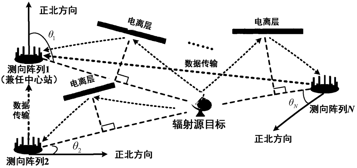
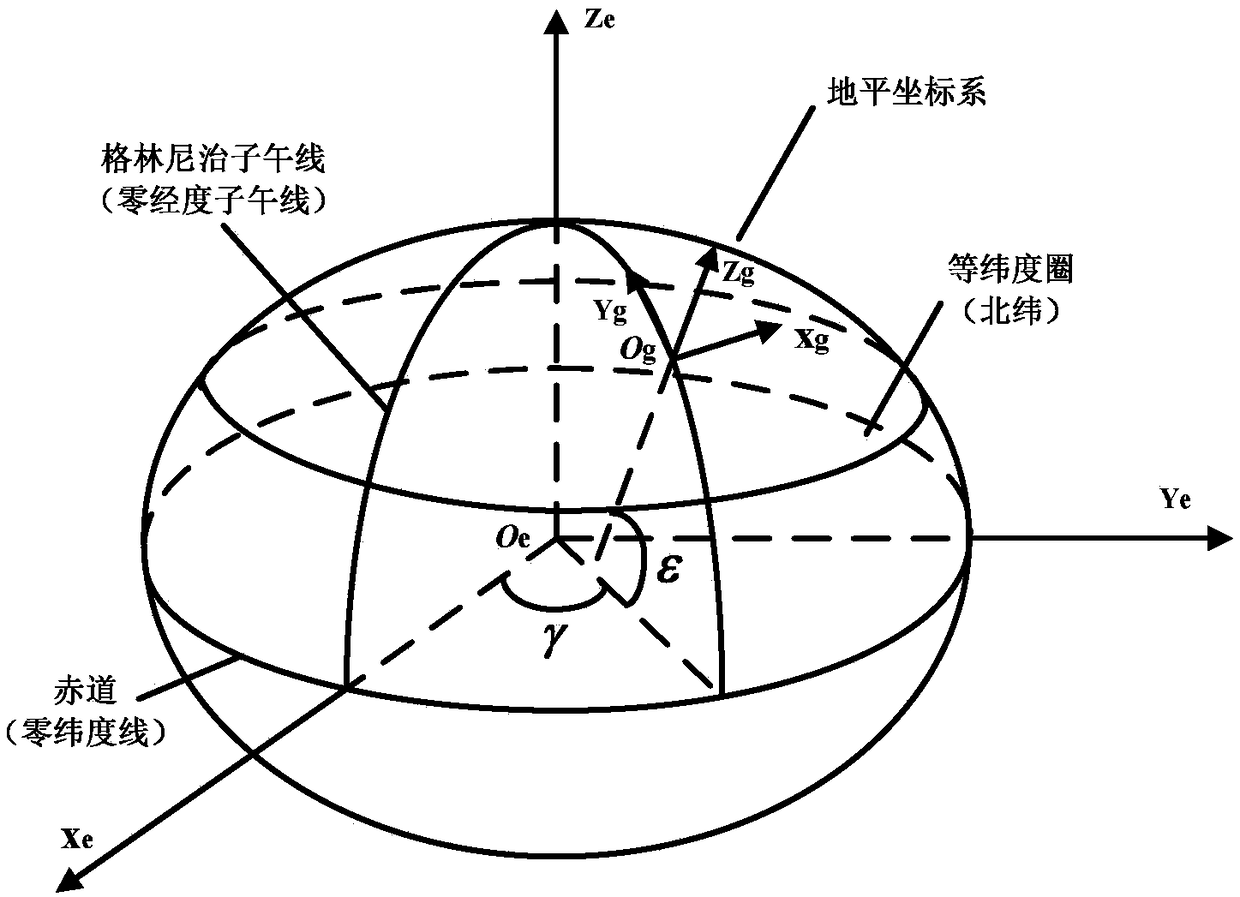
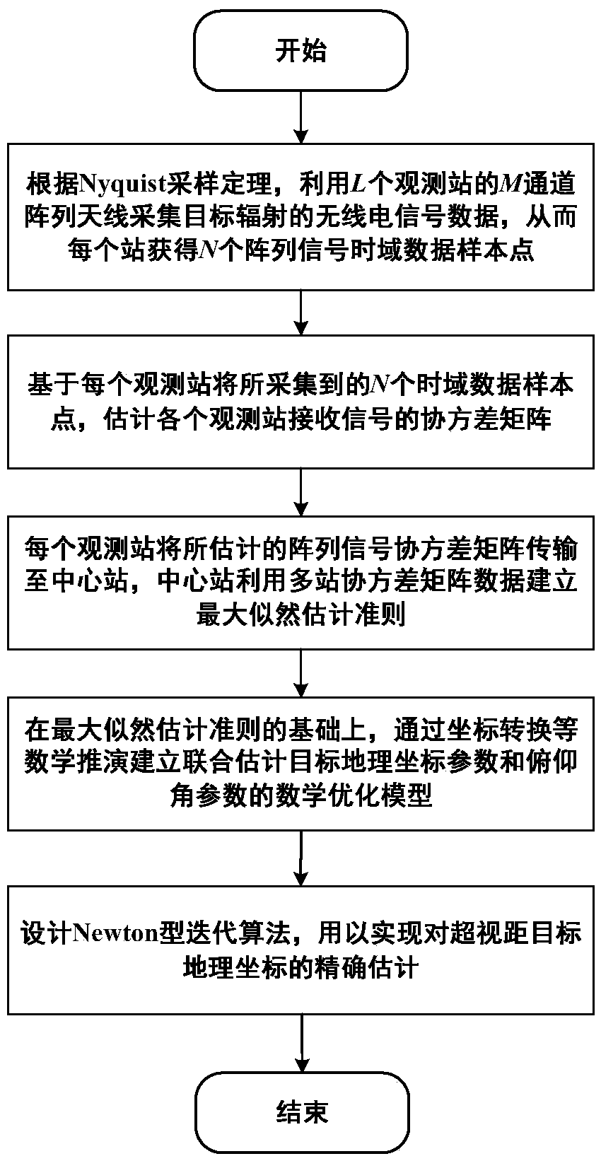
[0029] For problems such as the positioning accuracy of over-the-horizon targets and the limited signal-to-noise ratio threshold, such as figure 1 As shown, an antenna array is installed at each observation station, and each observation station will transmit the covariance sample data to the central station, and the central station can directly (jointly) estimate the geographic coordinate parameters and pitch angle parameters of the over-the-horizon target in the signal data domain . Such as figure 2 As shown in , the hidden relationship between the geographic coordinates of the earth and the azimuth angles of each station is used. Such as image 3 As show...


PUM


Abstract

The invention belongs to the technical field of radio signal positioning, in particular to an azimuth information-based beyond-visual-range target geographic coordinate direct estimation method; the method comprises the following steps of establishing a two-dimensional angle array signal model of each observation station, wherein the two-dimensional angles comprise an azimuth angle and a pitch angle, and calculating respective covariance matrixes; based on a ground plane coordinate system of each observation station, establishing a mathematical model of each station arrival azimuth angle relative to the target geographic coordinate parameters; utilizing the covariance matrix of each station, and establishing a mathematical optimization model for jointly estimating the target geographic coordinate parameters and the pitching angle parameters according to the maximum likelihood estimation criterion; and solving the mathematical optimization model through iteration, and obtaining a targetaddress coordinate. By adoption of the method, the target positioning precision under a low signal-to-noise ratio can be remarkably improved, the estimation precision of the target pitch angle is improved, and the convergence speed is relatively high, high-dimensional searching is not needed, and the calculation amount of real-time positioning can be effectively reduced; and the method is relatively high in practical application value, stable and reliable in performance, and efficient.

Description

technical field [0001] The invention belongs to the technical field of radio signal positioning, in particular to a method for directly estimating the geographic coordinates of an over-the-horizon target based on azimuth information. Background technique [0002] As we all know, radio signal positioning technology is very important for target discovery and situation awareness. After decades of development, this technology has made great progress in theory and engineering applications. According to the number of observation stations, the radio signal positioning system can be divided into two categories: single station positioning and multi-station positioning. The former has the advantages of simple system, high flexibility, no need for information synchronization and communication transmission, etc., while the latter can provide More observations, which help to obtain higher positioning accuracy in a shorter time. [0003] In the multi-station positioning system, the two m...

Claims


Application Information

Patent Timeline
Patent Type & Authority Applications(China)
IPC IPC(8): G01S5/02
CPCG01S5/0278
Inventor 尹洁昕王鼎杨宾魏帅沈彩耀李长胜贾昌贵孙晨
Owner PLA STRATEGIC SUPPORT FORCE INFORMATION ENG UNIV PLA SSF IEU
Why Eureka
Try Eureka