Method for positioning forest fire by forest fire fighting helicopter

A positioning method and helicopter technology, applied in the field of avionics, can solve problems such as inaccurate positioning of flight attitude

Active Publication Date: 2012-07-11
SHAANXI QIANSHAN AVIONICS
View PDF3 Cites 4 Cited by
  • Summary
  • Abstract
  • Description
  • Claims
  • Application Information

AI Technical Summary

Problems solved by technology

[0003] The purpose of the present invention is to provide a forest fire locating method for helicopter forest fire fighting, so that the position of the forest fire can be accurately positioned using the air

Method used


Image

  • Method for positioning forest fire by forest fire fighting helicopter
  • Method for positioning forest fire by forest fire fighting helicopter
  • Method for positioning forest fire by forest fire fighting helicopter

Examples


example

[0133] An example of the forest fire location method is given below. Suppose the parameters of the helicopter at time t1 are shown in the table below:

[0134]

[0135] The helicopter parameters at time t2 are shown in the table below:

[0136]

[0137]

[0138] Use this forest fire location method as follows:

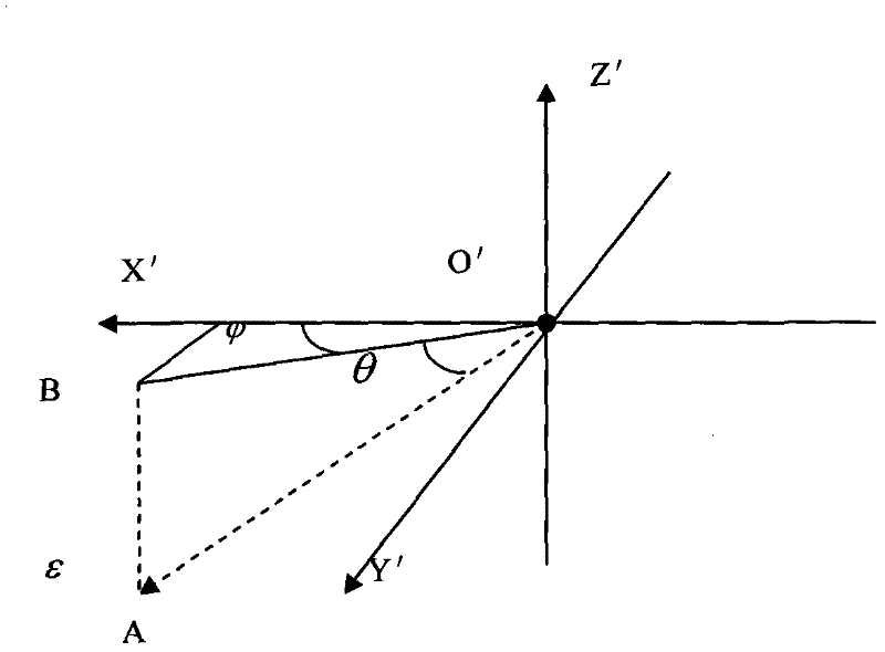
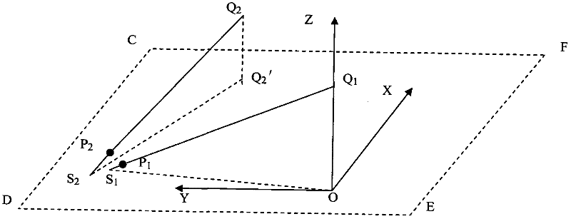
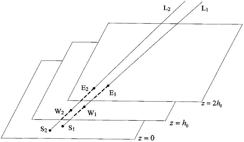
[0139] Step 1: Establish the body coordinate system O'X'Y'Z' and the earth coordinate system OXYZ.

[0140] Step 2: According to the pitch angle θ of the airborne infrared detection equipment 1 =-68, azimuth calculate t 1 The straight line L where the infrared optical axis of the airborne infrared detection equipment is located 1 The direction vector in the body coordinate system O′X′Y′Z′ is transformed into the earth coordinate system OXYZ:

[0141] (1) Calculate t 1 Time line L 1 The direction vector in the body coordinate system O'X'Y'Z'

[0142] (2) Calculate t 1 Time line L 1 Direction vector η in OXYZ coordinate system 1 .

[0143] Helico...


PUM


Abstract

The invention belongs to the technical field of avionics, and relates to a method for positioning a forest fire by a forest fire fighting helicopter. Onboard infrared detection equipment is used for detecting the forest fire in a forest; when detecting the forest fire, the infrared detection equipment informs an onboard computer, and outputs a pitching angle and an orientation angle of the infrared detection equipment at the moment; an aviation state sensor, an atmosphere sensor, a global positioning system (GPS) sensor and the like are used for acquiring flying parameters, such as the posture, the height, the position and the like of the helicopter; and the position of the forest fire is calculated according to the pitching angle and the orientation angle of the infrared detection equipment and the flying parameters. According to the method, the influence of a flying posture and a complicated terrain on the positioning precision is reduced greatly, so that a pilot can accurately position the forest fire at a position far away from the forest fire without driving the helicopter above the forest fire or close to the forest fire, and the safety is improved. According to the method, the position of the forest fire can be accurately and stably positioned, and firefighters can be correctly guided to put out the fire, so that relatively high loss can be avoided.

Description

technical field [0001] The invention belongs to the technical field of avionics and relates to a method for locating forest fires by helicopters. Background technique [0002] The forest firefighting helicopter is used in forest fire prevention and fire fighting and other tasks. By installing infrared detection equipment on the belly of the helicopter, the operator can rotate the operating lever on the operating platform in the cabin to detect forest fires in the forest, calculate the location of the forest fire, and send it to the forest fire prevention command department to guide the ground Firefighters extinguish the forest fire. Therefore, how to accurately locate the forest fire will directly affect whether the forest fire can be extinguished in time to avoid causing greater losses. At present, the ground forest fire infrared detection technology mainly uses infrared detection equipment to detect forest fires. When a forest fire is detected, the pitch angle and azimut...

Claims


Application Information

Patent Timeline
IPC IPC(8): G01C15/00A62C3/02
Inventor 刘华磊江舟
Owner SHAANXI QIANSHAN AVIONICS
Why Eureka
Try Eureka