Method for measuring river channel by use of ground effect aircraft

A technology of aircraft and effect, applied in the direction of measuring device, fluid velocity measurement, photogrammetry/video measurement, etc., can solve the problems of high economic cost, high manpower consumption, low efficiency, etc., and achieve high degree of automation and wide application range Extensive, saving human resources effect

Inactive Publication Date: 2012-09-26
HEILONGJIANG BOKAI TECH DEV
View PDF3 Cites 26 Cited by
  • Summary
  • Abstract
  • Description
  • Claims
  • Application Information

AI Technical Summary

Problems solved by technology

This method is labor-intensive and inefficient
Although the ship is equipped with a multi-beam depth sounder with a high degree of automation, its economic cost is high, and there is a risk of grounding when measuring on the edge of the river and in shallow water.

Method used


Image

  • Method for measuring river channel by use of ground effect aircraft
  • Method for measuring river channel by use of ground effect aircraft
  • Method for measuring river channel by use of ground effect aircraft

Examples


Embodiment Construction

[0043] Embodiments of the present invention will be described in detail below in conjunction with the accompanying drawings.

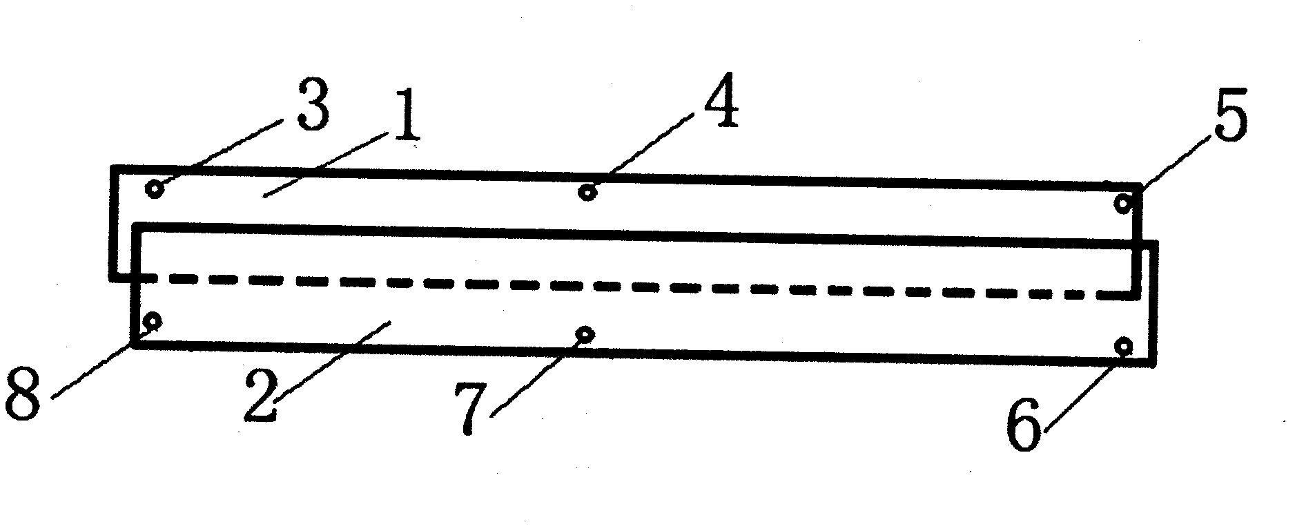
[0044] (1) Arrangement of control points for aerial photography

[0045] Firstly, the rough geographical location and terrain information of the river are obtained from the satellite map of the river to be measured, and the aerial photography process is planned. Due to the belt-shaped terrain of the river, the aerial photography of the river is divided into sections, so that each section of the river is covered by the forward navigation zone 1 and the reverse navigation zone 2, that is, when the ground effect aircraft is measuring a section of the river, the The shooting task can be completed with one flight. Set up control points A3, B4, and C5 at the starting point, midpoint, and end point of the forward track 1, respectively, and set up control points D6, E7, and F8 at the starting point, midpoint, and end point of the reverse track 2, respectively...


PUM


Abstract

The invention discloses a method for measuring a river channel by use of a ground effect aircraft, belonging to the river channel measuring technology.. The method comprises the following steps of: firstly performing aerial photography by use of the ground effect aircraft; planning the measuring track of the ground effect aircraft according to the river channel position information obtained by aerial photography; carrying a multibeam echosounder, an RTK measuring device and a flow velocity profiler on the ground effect aircraft to measure the river channel; and processing the data obtained by aerial photography, the measured data of the multibeam echosounder and the measured data of the flow velocity profiler to obtain the overwater / underwater three-dimensional topographic map of the river channel and the talweg and stream central line of the river channel. The method disclosed by the invention has the characteristics of low measuring cost, high degree of automation, wide range of application and digital mapping of the river channel terrain.

Description

technical field [0001] The invention relates to a river channel measurement technology, in particular to a river channel measurement method using a ground-effect aircraft as a measurement platform, combined with an aerial camera, an RTK measurement device, a multi-beam echo sounder and a velocity profiler. Background technique [0002] According to my country's "Waterway Observation Specifications", river measurement is divided into water topographic measurement, underwater topographic measurement and water flow velocity measurement at each point of the river. The water topographic survey needs to measure the plane position and height of the embankments and soil slopes along both banks of the river. The underwater topographic survey needs to measure the geographical distribution of the river bed and the hydrological environment, and use the measurement data to draw an underwater topographic map. In the map, the line connecting the deepest points of each section of the river ...

Claims


Application Information

Patent Timeline
Patent Type & Authority Applications(China)
IPC IPC(8): G01C13/00G01C11/00G01P5/24
CPCY02A90/30
Inventor 何昆鹏曹延哲王庭军于玖成詹俊妮管练武何云丰王福超郭凯文韩继涛
Owner HEILONGJIANG BOKAI TECH DEV
Why Eureka
Try Eureka