Tower footing section extracting method based on airborne laser radar data

A technology of airborne laser radar and extraction method, which is applied in the directions of section drawing, measuring device, surveying and navigation, etc., can solve the problems of low operation efficiency and poor environmental adaptability, and achieve high density of ground measuring points, high-precision measurement, and sampling high density effect

Active Publication Date: 2012-10-03
MIANYANG SKYEYE LASER TECH
View PDF1 Cites 14 Cited by
  • Summary
  • Abstract
  • Description
  • Claims
  • Application Information

AI Technical Summary

Problems solved by technology

[0005] Aiming at the technical defects of low operating efficiency and poor environmental adaptability existing in the current tower foundation section measurement method, the present invention proposes a tower foundation section measurement method based on airborne laser radar data with high efficiency and good environmental adaptability

Method used


Image

  • Tower footing section extracting method based on airborne laser radar data
  • Tower footing section extracting method based on airborne laser radar data

Examples


Embodiment Construction

[0012] Specific embodiments of the present invention will be described in more detail below.

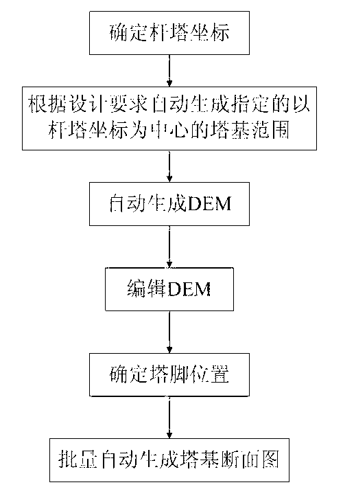
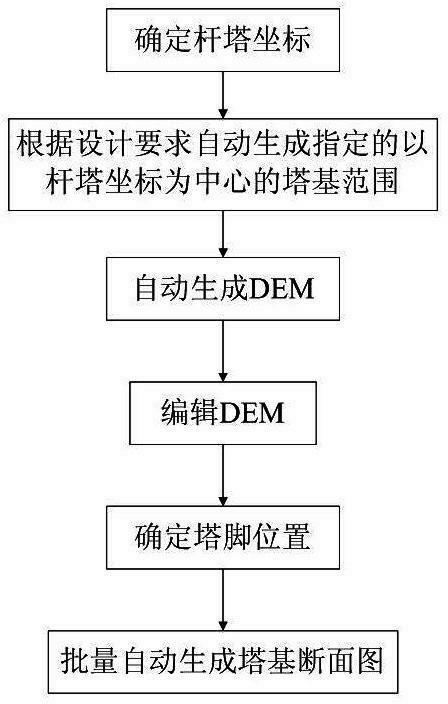
[0013] Such as figure 1 As shown, the specific implementation steps of a method for extracting tower base sections based on airborne lidar data according to the present invention are:

[0014] (1) Determine the coordinates of the tower

[0015] Import the digital elevation model DEM, digital surface model DSM, and contour lines into the 3D optimized line selection system based on the digital orthophoto map DOM, and combine the 2D images, real-time sections, and 3D scene diagrams to carry out optimal design of the line according to the line design specifications .

[0016] The design of overhead power transmission lines requires rich data information and a large amount of data. The application of a three-dimensional optimized line selection system that supports massive spatial data management can conveniently and quickly perform management and applications such as zooming in, zoomin...


PUM


Abstract

The invention discloses a tower footing section extracting method based on airborne laser radar data, which comprises the following steps of: determining a pole tower coordinate through line optimization design and tier pole positioning; automatically generating an appointed tower footing range according to design requirements; automatically generating a digital elevation model (DEM); editing the DEM by combining a high resolution orthoimage with point cloud data; determining a tower foot directional line and a tower foot coordinate according to the tower footing range, a tower type, a corner angle and the like; and automatically generating tower footing sections in batches. According to the tower footing section extracting method based on the airborne laser radar data, full-line tower footing section measurement can be completed indoors, and manual out-field work measurement is replaced, thus workload of fields, specially hill and high mountain areas, is greatly lowered, working efficiency is greatly increased, and remarkable economic and social benefits are achieved.

Description

technical field [0001] The invention belongs to the technical field of tower location positioning for overhead power transmission lines, and in particular relates to a method for extracting tower base sections based on airborne laser radar data. Background technique [0002] At present, the final survey and design of power lines above 220kV in China require the measurement of tower base sections. The common practice is to use surveying GPS receivers or total stations to measure the coordinates of corner points and pile points, manually record the category and characteristic attribute data of these points, and then convert the GPS coordinate data of corner points and pile points into professional Power software format (such as Daoheng ORG format), and then apply the corresponding software to generate tower base section. [0003] Most of the places where iron towers are erected are hilly or high mountain areas, and the terrain conditions are complex. It is very troublesome to...

Claims


Application Information

Patent Timeline
Patent Type & Authority Applications(China)
IPC IPC(8): G01C7/00
Inventor 窦延娟范应全董文武
Owner MIANYANG SKYEYE LASER TECH
Why Eureka
Try Eureka