Traffic safety dangerous point information collecting and prompting method

A technology for traffic safety and information collection, applied in the field of information collection and prompting of dangerous points in traffic safety, can solve problems such as user staying, and achieve the effects of accurate early warning, risk avoidance, and accident avoidance

Inactive Publication Date: 2012-10-24
胡东波
View PDF5 Cites 10 Cited by
  • Summary
  • Abstract
  • Description
  • Claims
  • Application Information

AI Technical Summary

Problems solved by technology

[0012] Third, although people have already felt the charm of GPS mobile phones, the vast majority of users still only know about navigation, positioning, search and other functions. Greater potential for applications in events

Method used


Image

  • Traffic safety dangerous point information collecting and prompting method
  • Traffic safety dangerous point information collecting and prompting method

Examples


Embodiment 1

[0029] A method for collecting and prompting traffic safety dangerous point information, comprising the following steps:

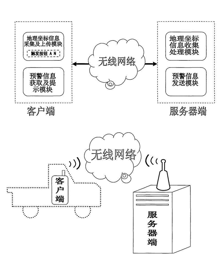
[0030] 1. "Geographic coordinate information collection and upload module" collects and uploads geographic coordinate information to the server. This module is generally placed on the client side, with positioning functions of geographic location coordinates, such as GPS positioning, mobile phone base station positioning (LBS-Location Based Service), etc., when traffic safety risks occur or are discovered, such as traffic accidents, bad weather, For geological disasters, etc., the party or witnesses press the "trigger button AN" to upload the geographical location coordinate information of the traffic safety hazard point to the server. Manual triggering can also be achieved by other means, such as switches, buttons, touch, voice commands, etc.

[0031] 2. "Geographic coordinate information collection and processing module" collects and processes geographi...


PUM


Abstract

The invention relates to a traffic safety dangerous point information collecting and prompting method. The traffic safety dangerous point information collecting and prompting method is characterized by comprising the following steps that 1) a client uploads geographical position coordinate information with traffic safety risk to a server; 2) the server collects and processes the information uploaded by the client and then feeds back the geographical position coordinate information with traffic safety risk to the client; and 3) after obtaining the feedback information, the client carries out traffic safety dangerous point prompting. The method has the advantage that the traffic safety dangerous point prompting is carried out after the traffic safety risk is found.

Description

technical field [0001] The invention relates to a method for collecting and prompting traffic safety dangerous point information. Background technique [0002] The positioning system is the Global Positioning System (Global Positioning System). Simply put, this is a satellite system consisting of 24 satellites covering the globe. This system can ensure that at any time, any point on the earth can observe four satellites at the same time, so as to ensure that the satellite can collect the latitude, longitude and altitude of the observation point, so as to realize functions such as navigation, positioning, and timing. Application practice has proved that the relative positioning accuracy of GPS can reach 10-6m within 50km, 10-7m within 100-500km, and 10-9m within 1000km. Widely used in space location services: such as car anti-theft, ground vehicle tracking and emergency lifesaving. Navigation: such as ship ocean navigation and port diversion, aircraft route guidance and ap...

Claims


Application Information

Patent Timeline
Patent Type & Authority Applications(China)
IPC IPC(8): G08G1/09G08G1/0967
Inventor 胡东波
Owner 胡东波
Why Eureka
Try Eureka