Positioning method based on coal mine underground wireless sensor network

A wireless sensor and positioning method technology, applied in wireless communication, network topology, electrical components, etc., can solve the problems of precise positioning, large signal attenuation fluctuations, and inability to give coordinate information, etc., to reduce equipment costs and improve accuracy and the effect of convenience

Inactive Publication Date: 2012-11-14
CHINA UNIV OF MINING & TECH (BEIJING)
View PDF3 Cites 7 Cited by
  • Summary
  • Abstract
  • Description
  • Claims
  • Application Information

AI Technical Summary

Problems solved by technology

At present, the commonly used method is to deploy nodes in parallel or staggered on the two side walls of the roadway, and perform positioning estimation based on the received signal strength indication of the RSSI value that decreases with the increase of the distance. However, the RSSI value is greatly affected by environmental factors, and the coal mine is closed Complexity, numerous obstacles, and large fluctuations in signal attenuation make precise positioning difficult
And this positioning can only roughly determine the interval where the target node is located, and cannot give more detailed coordinate information

Method used


Image

  • Positioning method based on coal mine underground wireless sensor network
  • Positioning method based on coal mine underground wireless sensor network
  • Positioning method based on coal mine underground wireless sensor network

Examples


Embodiment Construction

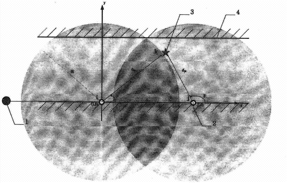
[0022] A positioning method based on wireless sensor networks in coal mines. Its characteristics are: by deploying anchor nodes equidistantly on the single side wall of the roadway, using the distance between the anchor nodes to divide the block, and first performing the local vector positioning of the target node, Combined with the anchor node ID, it is converted into the global coordinates of the roadway. The distance measurement in the local vector positioning can use weak current photoelectric sensors, infrared sensors or laser distance measurement sensors. These are mature distance measurement technologies underground and are easy to implement.

[0023] The invention combines figure 1 There are the following steps:

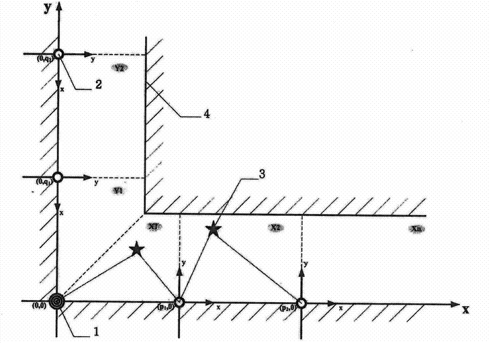
[0024] Step 1: Arrange the source nodes at the end of the straight roadway or at the right angle of the roadway with corners on the outer edge side, and each anchor node is also deployed on the outer edge side of the roadway at a one-dimensional equidistant ...


PUM


Abstract

The invention discloses a positioning method based on a coal mine underground wireless sensor network. The positioning method is characterized by arranging anchor nodes on the unilateral wall of a laneway at equal distances, dividing blocks by utilizing the intervals of the anchor nodes, firstly performing block local vector positioning on a target node, and further combining with ID (identity) conversion of the anchor nodes to form global coordinates of the laneway. According to the positioning method disclosed by the invention, the coal mine underground non-GPS (global positioning system) positioning limiting conditions can be met, positioning precision and convenience can be improved, the principle is simple and easy to implement, and equipment cost required for positioning is greatly reduced.

Description

technical field [0001] The invention relates to a positioning method, in particular to a positioning method based on a coal mine underground wireless sensor network, and belongs to the technical field of wireless network communication. Background technique [0002] my country's coal mine mining is mainly based on underground mining, and the underground environment of my country's coal mines is characterized by variability, particularity, and frequent hidden dangers of accidents. Coal mine safety issues are related to the safety of underground workers and social stability, and wireless sensor networks are more and more widely used in the field of coal mine safety monitoring due to their self-organization, flexible structure, and data-centric characteristics. Location information is crucial to the monitoring activities of wireless sensor networks. The location of the event or the location of the node that obtains the information is important information contained in the sensor...

Claims


Application Information

Patent Timeline
Patent Type & Authority Applications(China)
IPC IPC(8): H04W64/00H04W84/18
Inventor 孙继平陈炜
Owner CHINA UNIV OF MINING & TECH (BEIJING)
Why Eureka
Try Eureka