Isoline-based assistant navigation positioning method

A positioning method and technology for assisting navigation, applied in the field of navigation and positioning, can solve problems such as easy divergence, and achieve the effects of increasing reliability, improving matching accuracy, and high positioning accuracy

Inactive Publication Date: 2012-12-05
HARBIN ENG UNIV
View PDF2 Cites 24 Cited by
  • Summary
  • Abstract
  • Description
  • Claims
  • Application Information

AI Technical Summary

Problems solved by technology

[0005] The purpose of the present invention is to solve the above-mentioned problems. Aiming at the problem that the traditional auxiliary navigation algorithm is easy to diverge when the INS initial error is large, a method for auxiliary navigation and positioning based on contour lines is proposed. The present invention can greatly suppress this divergence And improve the integrated navigation method of INS navigation accuracy

Method used


Image

  • Isoline-based assistant navigation positioning method
  • Isoline-based assistant navigation positioning method
  • Isoline-based assistant navigation positioning method

Examples


Embodiment

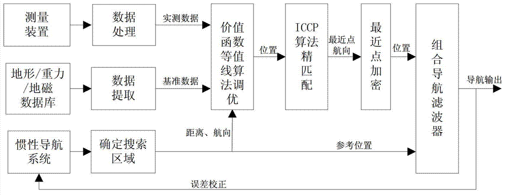
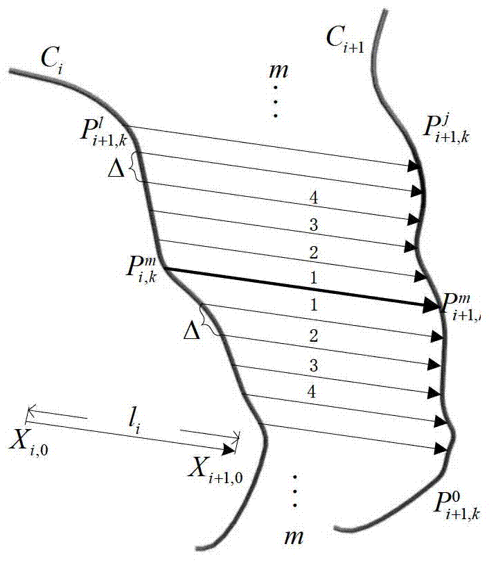
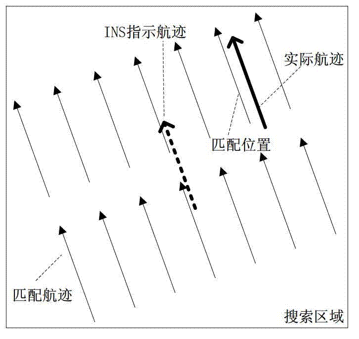
[0052] The simulation experiment uses a digital map with a resolution of 0.5′×0.5′ and a grid size of 72×82. Arbitrarily set a track as the actual track, and the INS indicated track is obtained by several translation transformations after the actual track is rotated by 15°. The initial matching position error in the latitude direction is 6.0′, and the sampling points of the ICCP algorithm are taken as is 9 o'clock, such as Figure 4 shown. The dotted square line in the figure is the actual track, the thick diamond line is the INS indicated track, and the thin diamond line is the matching track of the ICCP algorithm. Figure 5 For the final ICCP algorithm matching results, Table 1 shows the statistical results of ICCP matching errors when the initial position error is 6.0′.

[0053] Table 1

[0054]


PUM


Abstract

The invention discloses an isoline-based assistant navigation positioning method. The method specifically comprises the following steps: finding out a track relatively close to an actual track within a confidence region by utilizing an isoline matching algorithm based on a value function under relatively high initial matching error when an aircraft is started to perform topography/gravity/terrestrial magnetism matching, so as to reduce the initial positioning error of an inertial navigation system (INS); and then obtaining a course made good and the sequence information of the closet points based on the rotating and translation of an ICCP (iterative closest contour point) algorithm; and finally obtaining the optimum matching track from the isoline by utilizing an encrypting method based on the obtained course made good and the information of the closest point. By adopting the isoline-based assistant navigation positioning method disclosed by the invention, the problem that the assistant navigation system is easily subjected to diffusion under a high initial positioning error in the current assistant navigation system can be solved, and the precision and the reliability of the assistant navigation system can be improved; and the method is specially suitable for being applied to assisting the navigation positioning in the presence of a blind zone.

Description

technical field [0001] The invention relates to an auxiliary navigation and positioning method based on contour lines, belongs to the technical field of navigation and positioning, and is suitable for navigation and positioning when the INS accuracy is not high or the INS has a large position error in aviation or navigation. Background technique [0002] Passive autonomous navigation is one of the main trends in the development of aircraft at home and abroad. The inertial navigation system (Inertial Navigation System, INS) can provide more comprehensive navigation information around the clock, and has many advantages such as strong work autonomy and real-time performance, good passivity, no external signal transmission, strong anti-interference ability, etc. This makes INS one of the necessary navigation devices in aircraft. However, due to the problem of accumulation of position errors in INS, it cannot meet the long-term high-precision navigation requirements of submersib...

Claims


Application Information

Patent Timeline
Patent Type & Authority Applications(China)
IPC IPC(8): G01C21/16G01C21/20
Inventor 李宁张红伟张勇刚刘利强齐昭
Owner HARBIN ENG UNIV
Why Eureka
Try Eureka