Unmanned plane route planning and remote synchronous control method

A track planning and unmanned aerial vehicle technology, applied in the direction of three-dimensional position/channel control, etc., can solve the problems of money waste, bombing, complex operability, etc., achieve enhanced mobility, lower entry threshold, and good operating experience Effect

Inactive Publication Date: 2013-01-02
BEIJING UNIV OF TECH
View PDF4 Cites 71 Cited by
  • Summary
  • Abstract
  • Description
  • Claims
  • Application Information

AI Technical Summary

Problems solved by technology

[0002] UAV technology has entered a period of comprehensive development, and its navigation has become increasingly mature. However, in the civilian field, especially in households and entertainment venues, there is still no mature UAV system. In summary, there are three reasons. The development of UAVs in the civilian field is hindered; the first point is that due to the difficulty in operating UAVs, novices cannot quickly get started with them, otherwise they will face the risk of bombing at any time due to unfamiliar operations. This result is a waste of money. , which poses a certain threat to the personal safety of users; the second point is the interaction between the operating system and the drone. Nowadays, most ground stations are executed on computers, and external facilities such as mouse and keyboard are used in the operation process, resulting in Complicated operability and low user experience make users less interested in using this type of system; thirdly, because most ground stations are also executed on computers, this restricts the site environment used, making users only Able to operate the drone within a certain range where the computer can move

Method used


Image

  • Unmanned plane route planning and remote synchronous control method
  • Unmanned plane route planning and remote synchronous control method
  • Unmanned plane route planning and remote synchronous control method

Examples


Embodiment Construction

[0028] Below in conjunction with accompanying drawing and specific embodiment, the present invention will be further described:

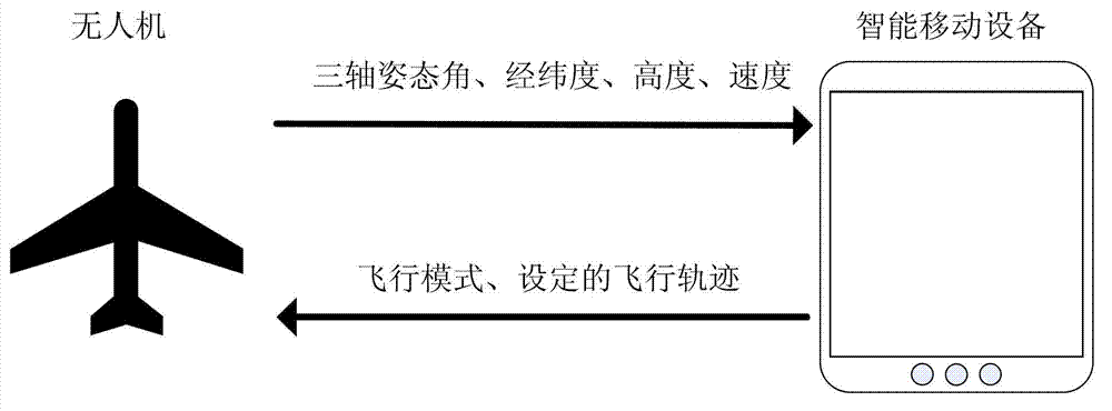
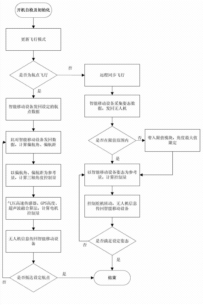
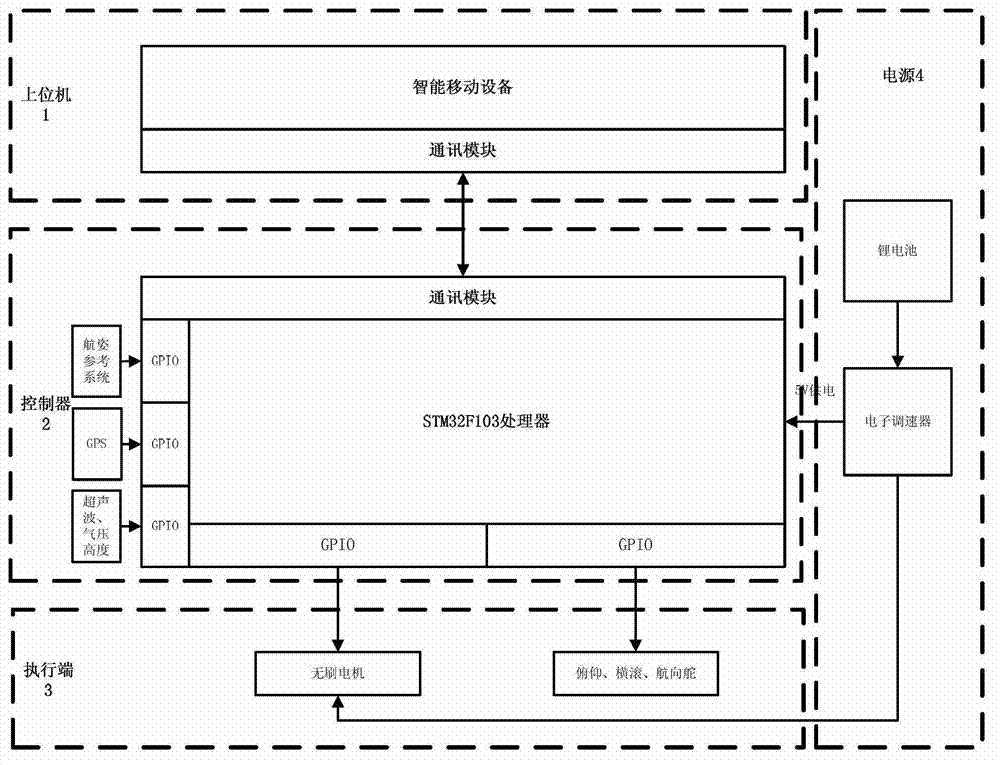
[0029] A new UAV track control method, such as figure 1 As shown, the data sent back by the drone is received through the smart mobile device, and some key data are displayed on the screen in the form of an intuitive dashboard, such as the three-axis attitude angle, altitude, and speed information, and the instructions and flight are set according to the touch screen. Path control information, send the control information back to the drone through an external wireless data transmission module or Wi-Fi. As the execution end, the UAV measures the attitude angle, latitude and longitude, and height information of the body through various sensors. After calculation by the internal algorithm, the current specific operations that the UAV needs to perform (such as motor speed, steering gear rotation angle) are obtained. , and send it to the smart mobile de...


PUM


Abstract

The invention provides an unmanned plane route planning and remote synchronous control method, and relates to the field of unmanned plane control. The method provided by the invention can be wieldy applied to intelligent mobile equipment including mobile phones and panel personal computers. A system can be divided into two major parts, wherein an unmanned plane serves as an actuating end for measuring attitude angle, the longitude and latitude and the height information of an airframe, and sending the information to the intelligent mobile equipment through a wireless data transmission module or a Wi-Fi module, and synchronously receiving the information returned via the intelligent mobile equipment, and executing relevant flight operation. The intelligent mobile equipment can be inclined and rotated to acquire the angle data output via a gyroscope and an accelerometer on the equipment, thus, the unmanned plane can perform the same action as the equipment; and the intelligent mobile equipment has he functions of receiving and displaying data, and returning the information to the unmanned plane through an external wireless data transmission module or the Wi-Fi based on the command and flight information set on a touch screen. With the adoption of the method provided by the invention, the flexibility of an unmanned plane system can be improved; and the unmanned plane system can be simply operated just like playing a game.

Description

technical field [0001] The invention relates to the field of unmanned aerial vehicle control, and is specifically applied to a system composed of intelligent mobile devices including mobile phones and tablet computers and unmanned aerial vehicles. Background technique [0002] UAV technology has entered a period of comprehensive development, and its navigation has become increasingly mature. However, in the civilian field, especially in households and entertainment venues, there is still no mature UAV system. In summary, there are three reasons. The development of UAVs in the civilian field is hindered; the first point is that due to the difficulty in operating UAVs, novices cannot quickly get started with them, otherwise they will face the risk of bombing at any time due to unfamiliar operations. This result is a waste of money. , which poses a certain threat to the personal safety of users; the second point is the interaction between the operating system and the drone. Now...

Claims


Application Information

Patent Timeline
Patent Type & Authority Applications(China)
IPC IPC(8): G05D1/10
Inventor 左国玉王恺阮晓钢李振
Owner BEIJING UNIV OF TECH
Why Eureka
Try Eureka