Automatic collecting method of high-resolution satellite remote sensing traffic flow information
A high-resolution, satellite remote sensing technology, applied in traffic flow detection, neural learning methods, instruments, etc., can solve problems such as low time efficiency and complex calculation, and achieve the effect of improved time efficiency, high degree of automation, and rapid acquisition
- Summary
- Abstract
- Description
- Claims
- Application Information
AI Technical Summary
Problems solved by technology
Method used
Image
Examples
Embodiment 1
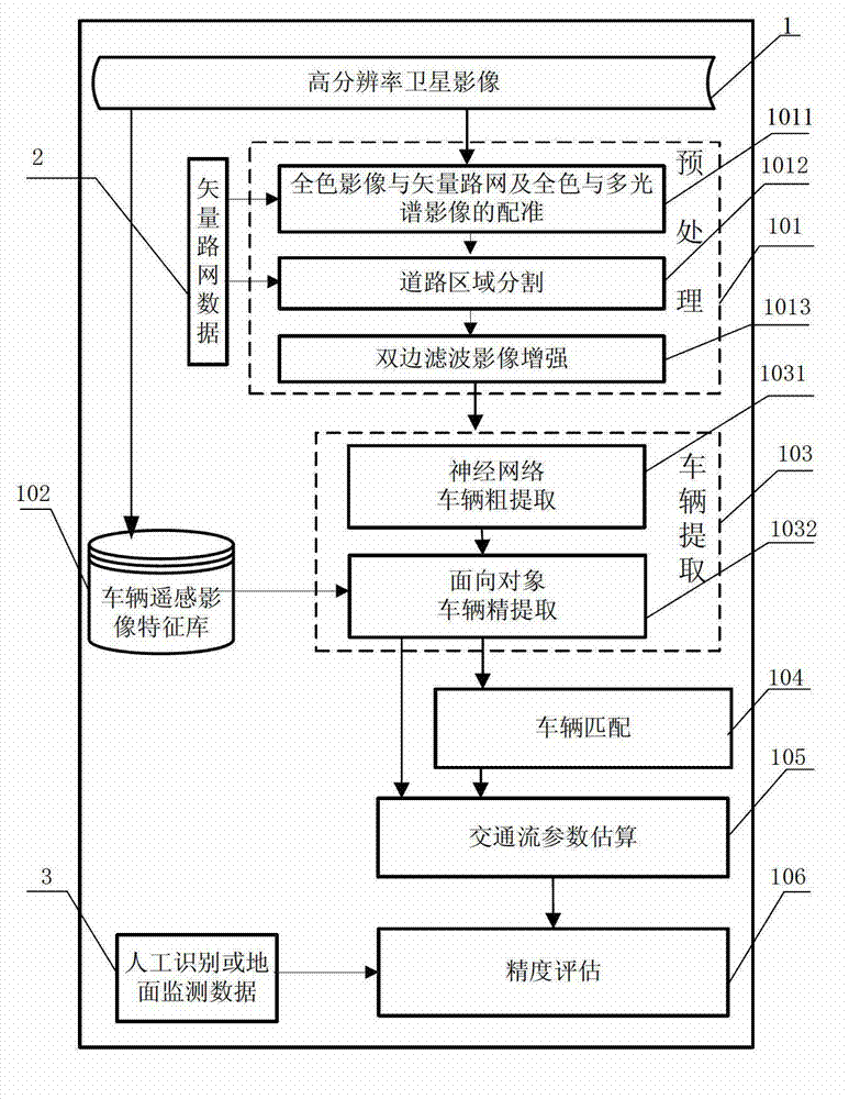
[0063] The present invention will be described in further detail below in conjunction with accompanying drawing and specific implementation case (such as figure 1 shown).
[0064] A method for automatically collecting high-resolution satellite remote sensing traffic flow information includes the following steps.
[0065] 1. Preprocessing 101:
[0066] In order to extract useful information from satellite remote sensing images, it is necessary to preprocess the input high-resolution satellite images1. The preprocessing included in the present invention includes: registration 1011 of panchromatic image and vector road network and panchromatic and multi-spectral image, road area segmentation 1012, bilateral filter image enhancement 1013. These three tasks deal with high-resolution panchromatic images and multispectral images (such as Quickbird) acquired by the same high-resolution remote sensing satellite platform at a certain time difference (greater than 0.2 seconds).
[006...
PUM
 Abstract
Description
Claims
Application Information
 - R&D
- Intellectual Property
- Life Sciences
- Materials
- Tech Scout
- Unparalleled Data Quality
- Higher Quality Content
- 60% Fewer Hallucinations
Browse by: Latest US Patents, China's latest patents, Technical Efficacy Thesaurus, Application Domain, Technology Topic, Popular Technical Reports.
© 2025 PatSnap. All rights reserved.Legal|Privacy policy|Modern Slavery Act Transparency Statement|Sitemap|About US| Contact US: help@patsnap.com


