
Navigation map updating method and device thereof based on GPS (Global Position System) navigating instrument

A technology for GPS navigation and navigation maps, applied in directions such as road network navigators, can solve the problems of untimely supplement and update of navigation map routes, and achieve the effect of timely discovery and measurement

Active Publication Date: 2013-01-16
ZHEJIANG GEESPACE TECH CO LTD +2
View PDF6 Cites 4 Cited by
  • Summary
  • Abstract
  • Description
  • Claims
  • Application Information

AI Technical Summary

Problems solved by technology

[0004] The present invention mainly solves the technical problems of navigation map route supplementation and untimely update in the prior art, and provides a navigation map update method and device based on a GPS navigator

Method used


Image

  • Navigation map updating method and device thereof based on GPS (Global Position System) navigating instrument
  • Navigation map updating method and device thereof based on GPS (Global Position System) navigating instrument

Examples


Embodiment

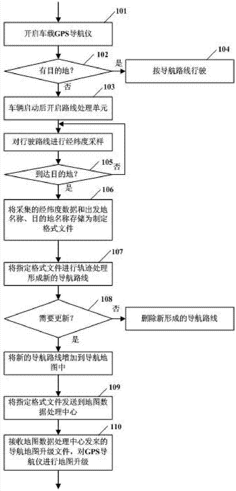
[0020] Example: figure 1 Shown is a flow chart of a method for updating a navigation map based on a GPS navigator, and the basic steps include:

[0021] Step 101, turn on the vehicle-mounted GPS navigator, and input the name of the destination;

[0022] Step 102, if the destination can be found, turn to step 104 and use the vehicle-mounted GPS navigator to drive according to the navigation route;

[0023] Step 103, if the destination cannot be found, the route processing unit is turned on after the vehicle is started, and the latitude and longitude sampling is performed on the driving route. The sampling point interval is set in advance, and the sampling data is automatically stored (to prevent accidental loss);

[0024] Step 105, if the destination is reached, the collected route latitude and longitude data, and the name of the departure place and the name of the destination are stored as a file in the data format required by the map drawing tool;

[0025] Step 106, the fil...


PUM


Abstract

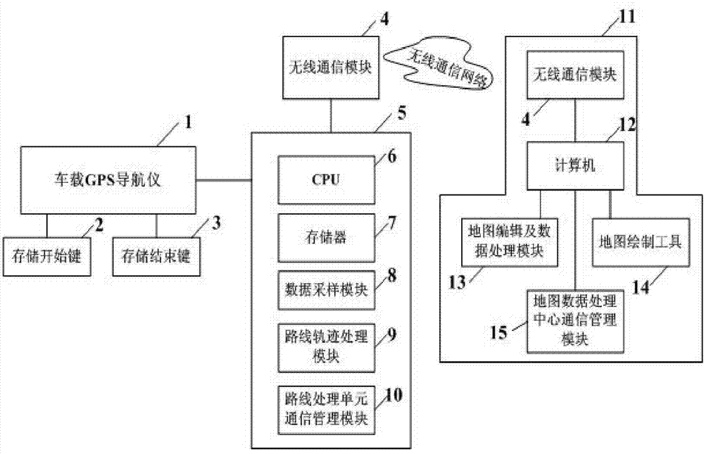
The invention discloses a navigation map updating method and a navigation map updating device based on a GPS (Global Position System) navigating instrument, and aims to solve the technical problem of the prior art that the navigation map route cannot be timely increased, compensated and updated. The navigation map updating method comprises the steps as follows: connecting a vehicle-mounted GPS navigating instrument with a route processing unit in a communicating manner; arranging a storage starting button and a storage finishing button on the vehicle-mounted GPS navigating instrument; starting the route processing unit when a destination cannot be searched from the vehicle-mounted GPS navigating instrument, thus sampling and recording the longitude and latitude of the route between the starting place to the destination based on points; adding the name of the starting place and the name of the destination after reaching the destination, and storing the name of the starting place and the name of the destination into documents with specified formats together; sequentially connecting the sampling points with longitude and latitude through tracks from the head to the end by utilizing the route processing unit based on the documents with the specified formats, so as to form a new navigation route; and transmitting the new navigation route to the vehicle-mounted GPS navigation instrument and the like.

Description

technical field [0001] The invention relates to a GPS navigation device, in particular to a method and device for updating a navigation map based on a GPS navigator. Background technique [0002] The GPS navigation system has become more and more popular, but the existing navigation system can only navigate according to the built-in electronic map. During the driving process of the vehicle, because the GPS navigation system is not updated in time, the unfamiliar route cannot be reproduced, and convenient and quick information cannot be provided for the driver. As my country's urban and rural construction is changing with each passing day, and the average annual change rate of urban and rural roads is relatively large, the products with the highest update frequency in my country's navigation electronic map market can only update twice a year for important cities, and only once a year for provincial capitals and general cities. The update of road data is difficult to guarantee...

Claims


Application Information

Patent Timeline
Patent Type & Authority Applications(China)
IPC IPC(8): G01C21/32
Inventor 赵书美魏冬李永生门永新赵福全
Owner ZHEJIANG GEESPACE TECH CO LTD
Learn More