2D seismic data all-horizon automatic tracking method based on unsupervised classification

A seismic data and automatic tracking technology, applied in the field of seismic exploration data interpretation, can solve problems such as large impact, training samples cannot cover all conditions, approximation degree problem solving method solution accuracy, etc.

Active Publication Date: 2013-03-20
BC P INC CHINA NAT PETROLEUM CORP +1
View PDF3 Cites 35 Cited by
  • Summary
  • Abstract
  • Description
  • Claims
  • Application Information

AI Technical Summary

Problems solved by technology

However, there are big problems in manual extraction: firstly, manual extraction relies on the long-term work experience of interpreters, and subjective factors have a great influence; secondly, manual interpretation has great efficiency problems, and can only explain a small number of horizons , it is impossible to track all layers, and it is usually difficult to provide basic data for fine seismic data analysis (such as seismic stratigraphic interpretation)
[0003] The existing horizon tracking methods include: (1) P.Alberts et al. proposed a horizon tracking algorithm based on artificial neural network in 2002, which mainly introduces pattern recognition into horizon tracking of discontinuous geological structures such as faults, Then use neural network for pattern recognition; (2) Reda Benbernou et al. use fuzzy means to make judgments based on the work of P.Alberts, and form a mixed layer automatic tracking method; (3) M.Aurnhammer et al. proposed a method in 2002 A genetic algorithm layer tracking algorithm, the specific idea is to use a model-based method to deal with the problem of crossing faults, and then transform the problem into a constrained optimization problem, and then use the genetic algorithm to solve it; (4) F.Admasu et al. In 2004, the simulated annealing method was used to solve the constrained optimization problem, and in 2006, the Bayesian method was discussed to solve the constrained optimization problem; (5) F.Admasu et al introduced the wavelet transform into the horizon tracking problem in 2006 In 2011, the seismic data wavelet multi-scale decomposition was performed first, and then horizon tracking was performed, still using the Bayesian method; (6) Yingwei Yu et al. used the orientation vector field to obtain horizon extremum information in 2011, and constructed the target horizon The module is an undirected connected graph, and then use the minimum spanning tree to obtain the target layer, but this way of thinking cannot perform full-layer layer tracking; (7) Hilde G.Borgos et al. introduced a full-layer layer tracking algorithm based on finite mixture Gaussian in 2005 , since horizon tracking is transformed into classification (including supervised classification and semi-supervised classification), there is no cross-fault problem and it is suitable for complex geological environments
[0004] However, the existing horizon tracking methods have the following problems: (1) The ability of P.Alberts and RedaBenbernou’s neural network method to cross complex geological environments is closely related to the condition of the training samples. If the training samples contain such complex geological conditions, it can easily It is easy to track, otherwise it cannot, but for the changeable and complex geological environment, the training samples often cannot contain all the conditions, and the acquisition of the training samples requires a lot of manual intervention and labeling; (2) The model methods of M.Aurnhammer and F. The problem of the approximation of complex geological conditions and the solution accuracy and suboptimal solution of the solution method; (3) supervised classification mainly includes maximum likelihood and Bayesian classification, using a large amount of manually marked data for training, and then using unidentified The identified data is used to test its performance. The classifier has a high classification accuracy. Compared with the supervised classification, the semi-supervised classification needs to identify a lot less samples, but the corresponding classification accuracy will decrease. However, based on supervised classification and The classification method of semi-supervised classification requires manual intervention and cannot achieve complete automatic full-level tracking

Method used


Image

  • 2D seismic data all-horizon automatic tracking method based on unsupervised classification
  • 2D seismic data all-horizon automatic tracking method based on unsupervised classification
  • 2D seismic data all-horizon automatic tracking method based on unsupervised classification

Examples


Embodiment Construction

[0037] The following description with reference to the accompanying drawings is provided to assist in a comprehensive understanding of embodiments of the present invention as defined by the claims and their equivalents. Various specific details are included to aid in understanding but are to be regarded as exemplary only. Accordingly, those of ordinary skill in the art will recognize that various changes and modifications of the embodiments described herein can be made without departing from the scope and spirit of the invention. Also, descriptions of well-known functions and constructions are omitted for clarity and conciseness.

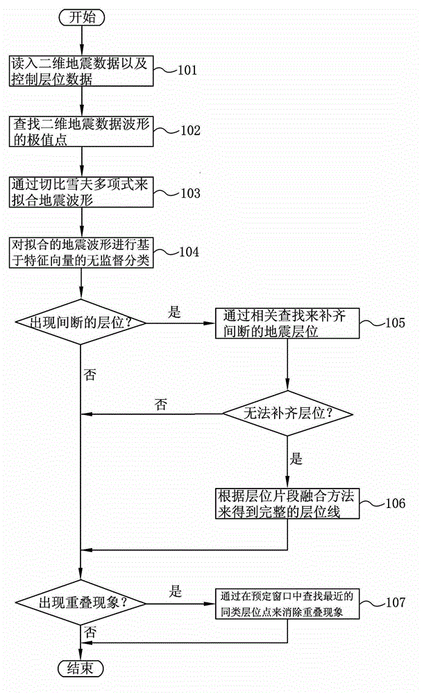
[0038] figure 1 It is a flow chart of the method for automatic tracking of full horizons of two-dimensional seismic data based on unsupervised classification according to the present invention.

[0039] refer to figure 1 , in step 101, read in 2D seismic data and control horizon data. Wherein, the two-dimensional seismic data may include the sta...


PUM


Abstract

The invention provides a 2D seismic data all-horizon automatic tracking method based on unsupervised classification. The method includes reading in 2D seismic data and control horizon data; searching an extreme point of a 2D seismic data waveform; fitting the seismic waveform based on the searched extreme point and according to the Chebyshev polynomials, and taking a fitting coefficient as the eigenvector; and performing eigenvector-based unsupervised classification on the fit seismic waveform to obtain the all-horizon automatic tracking result of the 2D seismic data. The method further includes polishing discontinuous seismic horizon through relevant searching; obtaining a complete horizon line through a horizon segment merging method; and eliminating overlapping through relevant searching. According to the method, a manual intervention mechanism is eliminated and complete 2D seismic data all-horizon automatic tracking is achieved.

Description

technical field [0001] The invention belongs to the field of seismic exploration data interpretation, and in particular relates to a layer tracking method for two-dimensional seismic data. Background technique [0002] Horizon tracking (ie, horizon interpretation) is an important part of geological data interpretation. Horizon tracing is to analyze the subsurface structure through the seismic data obtained by seismic exploration. For a long time, seismic horizon tracking has relied on manual extraction. However, there are big problems in manual extraction: firstly, manual extraction relies on the long-term work experience of interpreters, and subjective factors have a great influence; secondly, manual interpretation has great efficiency problems, and can only explain a small number of horizons , it is impossible to track all layers, and it is usually difficult to provide basic data for fine seismic data analysis (such as seismic stratigraphic interpretation). With the con...

Claims


Application Information

Patent Timeline
Patent Type & Authority Applications(China)
IPC IPC(8): G01V1/28
Inventor 陈小二邹文陶正喜巫盛洪周晶晶杜洪刘璞巫骏吕文彪
Owner BC P INC CHINA NAT PETROLEUM CORP
Why Eureka
Try Eureka