Method applied to unmanned aerial vehicle for improving navigation calculating precision

A technology of navigation calculation and unmanned aerial vehicles, which is applied in the field of improving the accuracy of navigation calculation, to achieve the effect of satisfying precise guidance, improving calculation accuracy and reducing truncation error

Inactive Publication Date: 2013-04-03
BEIHANG UNIV
View PDF5 Cites 4 Cited by
  • Summary
  • Abstract
  • Description
  • Claims
  • Application Information

AI Technical Summary

Problems solved by technology

[0005] However, when the positioning accuracy of DGPS is 0.1m, using 32-bit floating-point type libra

Method used


Image

  • Method applied to unmanned aerial vehicle for improving navigation calculating precision
  • Method applied to unmanned aerial vehicle for improving navigation calculating precision
  • Method applied to unmanned aerial vehicle for improving navigation calculating precision

Examples


Embodiment Construction

[0028] The description will be described in detail below in conjunction with the accompanying drawings and embodiments.

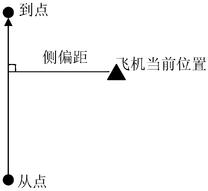
[0029] The flight route of the UAV is connected by several waypoints. When the UAV flies from the waypoint m to the waypoint n, it is said that the UAV is flying on the flight segment m→n, and the waypoint m is the current UAV. The starting point of , waypoint n is the arrival point of the current UAV. Such as figure 1 As shown, the from point and the to point are the projections of the current drone's from point and to point on the horizontal plane, then the vertical distance between the projection of the current aircraft position on the horizontal plane and the line from point → to point is called the lateral deviation The side offset is positive when the aircraft is on the right side of the flight path.

[0030] The general navigation solution method includes a large number of trigonometric and inverse trigonometric operations. The existing TMS320 seri...


PUM


Abstract

The invention discloses a method applied to an unmanned aerial vehicle for improving navigation calculating precision, and belongs to the field of aerial automation control. The method specifically comprises the following steps: 1, acquiring starting point information, destination point information and current position information of the unmanned aerial vehicle; 2, splitting longitude data, latitude data and height data of forty floating point types in the starting point, the destination point and the current position, so as to obtain a trigonometric function equation of the data of the forty floating point types; and 3, acquiring laterodeviation distance and laterodeviation speed according to the starting point information, the destination point information and the current position information obtained in step 1 of the unmanned aerial vehicle, and rectifying the deviation of a track route of the unmanned aerial vehicle according to the laterodeviation distance and the laterodeviation speed. According to the method applied to the unmanned aerial vehicle for improving navigation calculating precision, the navigation calculation of the forty floating point types is carried out, thus the intercepting error occurring in the operation can be reduced, and the calculation precision can be improved; once the position precision of a DGPS (Differential Global Positioning System) is 0.1m, the laterodeviation distance output precision under the navigation calculation of the forty floating point types can reach 0.3m, and thus the purposes of precise guiding, taking off and landing control can be met.

Description

technical field [0001] The invention belongs to the field of aviation automation control, and in particular relates to a method for improving the accuracy of navigation calculation applied to an unmanned aerial vehicle. Background technique [0002] DSP chip, that is, digital signal processing chip, also known as signal processor, is a microprocessor that is especially suitable for digital signal processing operations. Its main application is to realize various digital signal processing algorithms in real time and quickly. The most successful DSP chips are a series of products from Texas Instruments (TI). TI has become the world's largest supplier of DSP chips, and its DSP market share accounts for nearly 50% of the global total. [0003] Because TI's TMS320 series general-purpose DSP chip has the advantages of convenient interface, convenient programming, good stability, high precision, good repeatability, and convenient integration, etc., the digital signal processing cap...

Claims


Application Information

Patent Timeline
IPC IPC(8): G05D1/10G01C21/20
Inventor 舒婷婷王宏伦
Owner BEIHANG UNIV
Why Eureka
Try Eureka