Method for extracting contour and corner of building from ground LiDAR data

A building and outline technology, applied in the field of extracting building outlines and corner points, can solve the problems of affecting clustering results, large errors and computations, and relying on initial seed areas, so as to improve data processing efficiency and accuracy. Effect

Inactive Publication Date: 2013-04-03
NANJING UNIV
View PDF3 Cites 35 Cited by
  • Summary
  • Abstract
  • Description
  • Claims
  • Application Information

AI Technical Summary

Problems solved by technology

In 2004, Wang and Tseng wrote "Lidar data segmentation and classification based on octree structure" in "parameters", and proposed an octree segmentation and merging algorithm that can cluster LiDAR point clouds into faces, but the growth process of this method Depending on the selection of the initial seed area, different seed areas directly affect the final clustering results
In 2007, Bohm et al. wrote an article "Efficient integration of aerial and terrestrial laser data for virtual city modeling using lasermaps" in the "ISPRS Workshop Laser scanning 2005" conference proceedings. They constructed an irregular triangular network for the point cloud data, and determined it according to the elevation of the triangular network. Roof patch and ground patch, and then determine the edge of each patch, the algorithm uses TIN to determine the edge, the error and calculation amount are large
The grid density method is simple and fast, but the determination of the grid density threshold is directly related to the integrity of building outline extraction. How to accurately and automatically determine the grid density threshold for building outline screening is seldom involved.

Method used


Image

  • Method for extracting contour and corner of building from ground LiDAR data
  • Method for extracting contour and corner of building from ground LiDAR data
  • Method for extracting contour and corner of building from ground LiDAR data

Examples


Embodiment Construction

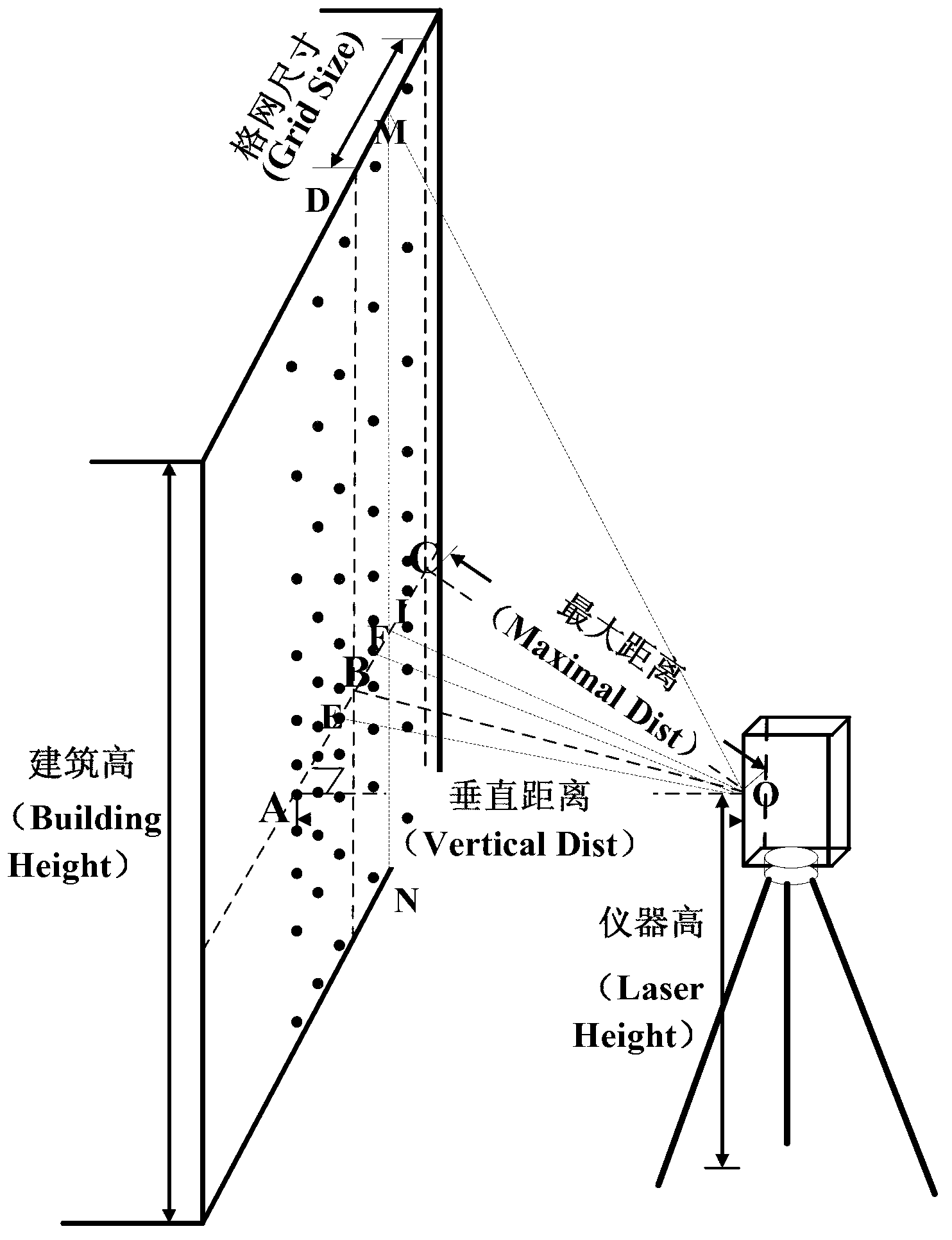
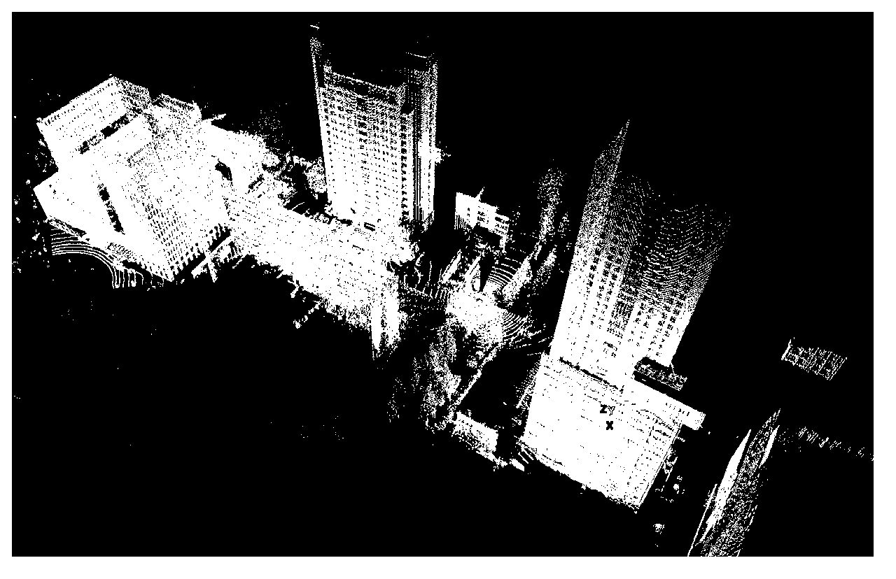
[0041] The ground LiDAR data of this embodiment is such as figure 1 shown. The data was scanned by Leica ScanStation2 and 9 stations. The total number of LiDAR points is about 30 million, and the resolution of ground LiDAR points is 20cm at a distance of 100m.

[0042] From the example of this example figure 1 A method for extracting building outlines from ground LiDAR data, comprising the steps of:

[0043] 1a) Project the ground LiDAR point cloud to the XY plane—project the ground LiDAR point cloud to the XY plane of the three-dimensional coordinate system, and retain the X, Y, and Z attributes of each point.

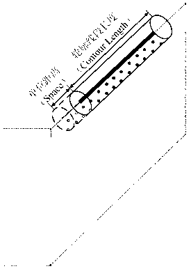
[0044] 1b) Extract a rough outline grid—construct a 1m*1m rough grid in the XY plane (see figure 2 ), calculate the number of LiDAR projection points in each rough grid, that is, get the grid density of the rough grid, filter the rough grid according to the rough grid density threshold at the edge contour of the building, and keep the grid A rough grid whose dens...


PUM


Abstract

The invention relates to a method for extracting a contour and a corner of a building from ground LiDAR data. At first, a hierarchical grid density method is adopted to extract the contour of the building from the ground LiDAR data; then a contour extension density method is adopted to restore the extracted contour of the building to obtain the complete contour of the building; and when a corner needs to be extracted, the complete contour of the building is projected into an XY plane with a three-dimensional coordinate system to seek a two-dimensional intersection point, and if the elevation difference of contours of intersection points of any two lines is less than 1m, two contours can be judged to be intersected in the actual three-dimensional space, the intersection point of the two contours is a ground corner, and the average of the elevations of the two contours can be used as the elevation of the ground corner. By adopting the grid density method, the method for theoretical estimation and determination of the grid density threshold and the contour density extension method, the accurate contour segment of the building and the precise ground corner can be extracted from the ground LiDAR data. Moreover, automated extraction can be realized, and the efficiency of data processing can be improved greatly.

Description

technical field [0001] The invention relates to a method for extracting building outlines and corner points from ground LiDAR data. Background technique [0002] At present, lidar technology is developing rapidly, and the lidar family has ushered in aviation lidar, ground lidar, vehicle lidar, and indoor lidar. The performance of LiDAR on different platforms is different, and the scope of application is also different, but on the other hand, they also complement each other. With the continuous advancement of lidar technology, the fusion processing of lidar from multiple platforms has gradually become a trend, especially the integration of aerial and ground LiDAR data. Aerial lidar has a large scanning range and can obtain information on the top of objects. However, the phenomenon of point cloud banding is obvious and the side information of ground objects is missing. Ground lidar can obtain detailed side information of ground objects, and the scanning accuracy is also very ...

Claims


Application Information

Patent Timeline
Patent Type & Authority Applications(China)
IPC IPC(8): G06F17/50
Inventor 李满春程亮童礼华陈焱明刘永学王结臣钟礼山张雯陈小雨孙越凡
Owner NANJING UNIV
Why Eureka
Try Eureka