Deep space detector astronomy/radio combination navigation method based on ephemeris correction

A technology of radio navigation and deep space detectors, applied in the direction of integrated navigators, etc., can solve the problems of no real-time correction of state model model errors, low navigation accuracy relative to the sun, and low navigation accuracy

Active Publication Date: 2013-04-24
BEIHANG UNIV
View PDF6 Cites 27 Cited by
  • Summary
  • Abstract
  • Description
  • Claims
  • Application Information

AI Technical Summary

Problems solved by technology

Due to the large error of target celestial ephemeris and the limited measurement accuracy of astronomical sensors, these two methods still have the following deficiencies: the radio navigation method can only obtain navigation information relative to the sun, so the relative target celestial navigation obtained by this method The information is greatly affected by the ephemeris error of the target celestial body, and the navigation accuracy of the relative target celestial body is low; the celestial navigation method is affected by the factor of the limited accuracy of the celestial navigation sensor, and the accuracy of the relative target celestial navigation information obtained by it is limited, and is affected by the target celestial body. Due to the influence of ephemeris error, the accuracy of relative solar navigation obtained by this method is low
However, since this method does not correct the model error of the state model in real time, it still cannot eliminate the influence of the target celestial body ephemeris error on the accuracy of the detector state model, and the navigation accuracy is still low.

Method used


Image

  • Deep space detector astronomy/radio combination navigation method based on ephemeris correction
  • Deep space detector astronomy/radio combination navigation method based on ephemeris correction
  • Deep space detector astronomy/radio combination navigation method based on ephemeris correction

Examples


Embodiment Construction

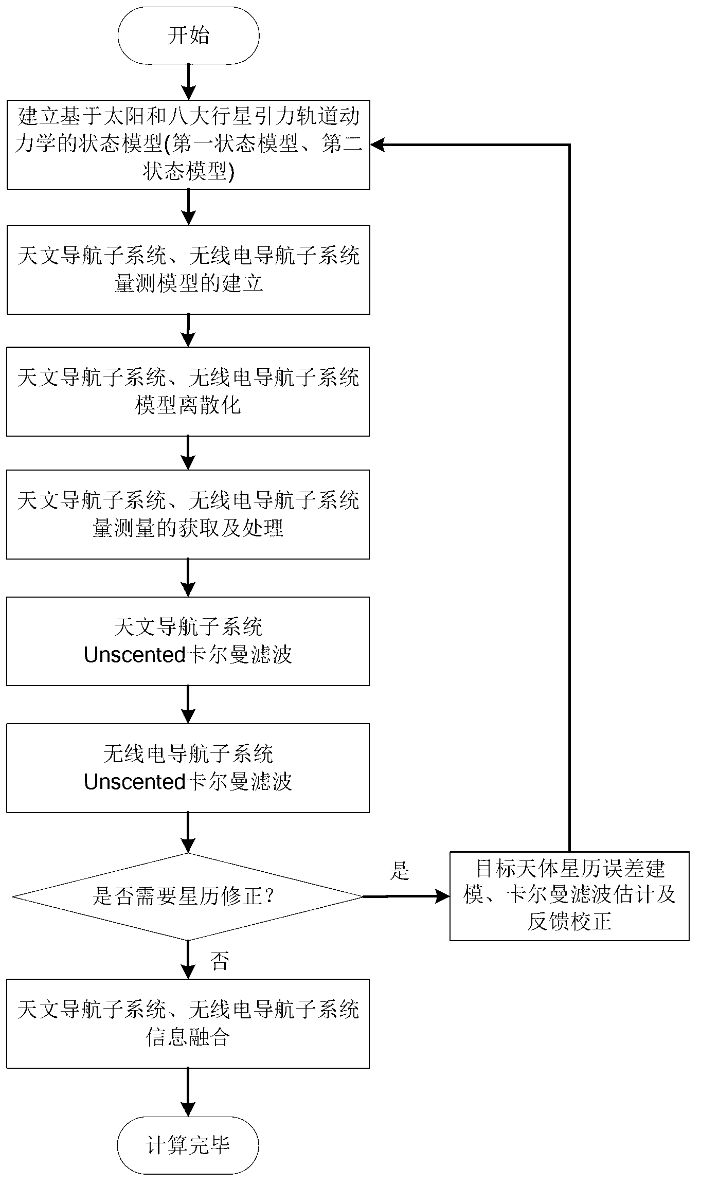
[0091] like figure 1 As shown, the target celestial bodies involved in the foregoing technical solutions can be celestial bodies in the solar system such as Mars, Venus, Jupiter, Saturn, etc., and Mars is used as an example below to illustrate the specific implementation process of the present invention:

[0092] 1. Establish a state model of deep space probes based on the gravitational orbital dynamics of the sun and eight planets

[0093] First initialize the position and velocity, set X=[x y z v x v y v z ] T is the state vector in the heliocentric inertial coordinate system, x,y,z,v x ,v y , v z are the three-axis position and velocity of the detector in the heliocentric inertial coordinate system, X′=[x′ y′ z′ v x ' v y ' v z '] T is the state vector in the center of fire inertial coordinate system, x′,y′,z′,v′ x ,v′ y ,v′ z are the three-axis position and velocity of the detector in the inertial coordinate system of the center of fire, respectively. The ab...


PUM


Abstract

The invention relates to a deep space detector astronomy/radio combination navigation method based on ephemeris correction. The method comprises the following steps: establishing a Mars detector state model and astronomy astronomy navigation and radio navigation subsystem measurement models, acquiring the measured values of astronomy and radio navigation subsystems, and carrying out filtering estimation to obtain the position of the detector in an inertia coordinate system treating a target heavenly body as a center and the speed of the detector; and establishing the ephemeris error state model and the measurement model of the target heavenly body based on the position and the speed, obtaining the ephemeris error measurement value of the target heavenly body according to the estimation states of the two astronomy and radio navigation subsystems, utilizing a Kalman filtering method estimate the ephemeris error of the target heavenly body, feeding back to a navigation system model, and carrying out information fusion. The deep space detector astronomy/radio combination navigation method belongs to the technical field of spaceflight and navigation, can realize the online estimation of the heavenly body ephemeris error and the correction of the navigation system model error, and is suitable for the capture segment of a detector.

Description

technical field [0001] The invention relates to a combined navigation method based on target celestial body image and radio signal time delay and frequency shift information when the deep space probe is in the capture phase, and is very suitable for the combined navigation method in the capture phase of the deep space probe. Background technique [0002] As an important feature and symbol of a country's comprehensive national strength and scientific and technological development level, deep space exploration technology has attracted great attention from all countries in the world. A new round of competition for deep space exploration has kicked off. At the beginning of the 21st century, all major aerospace powers focused their attention on the deep space universe 380,000 kilometers away from the earth. The world's major aerospace groups, including the United States, European Space Agency, Russia, Japan, and India, have all proposed future deep space exploration plans to con...

Claims


Application Information

Patent Timeline
Patent Type & Authority Applications(China)
IPC IPC(8): G01C21/24
Inventor 房建成马辛宁晓琳
Owner BEIHANG UNIV
Why Eureka
Try Eureka