A Robust Estimation Method for Rational Function Model Parameters of Satellite Remote Sensing Imagery

A technology of satellite remote sensing images and model parameters, applied in the field of surveying and mapping science, can solve problems such as affecting the accuracy of the solution, ill-conditioned normal equations, etc., and achieve the effects of high-precision estimation, overcoming ill-conditioning, and improving robustness and accuracy.

Inactive Publication Date: 2017-03-08
HUBEI UNIV OF TECH
View PDF3 Cites 0 Cited by
  • Summary
  • Abstract
  • Description
  • Claims
  • Application Information

AI Technical Summary

Problems solved by technology

[0010] Aiming at the disadvantages of normal equations being ill-conditioned and affecting the solution accuracy in the current satellite remote sensing image RFM model parameter calculation process, the present invention proposes a robust satellite remote sensing image rational function model parameter estimation method

Method used


Image

  • A Robust Estimation Method for Rational Function Model Parameters of Satellite Remote Sensing Imagery
  • A Robust Estimation Method for Rational Function Model Parameters of Satellite Remote Sensing Imagery
  • A Robust Estimation Method for Rational Function Model Parameters of Satellite Remote Sensing Imagery

Examples


Embodiment 1

[0023] Taking the solution of the parameters of the RFM model of a SAR satellite remote sensing image as an example, using a calculation method that has nothing to do with the terrain, the steps are described in detail as follows:

[0024] The first step is to establish a grid of control points and a grid of checkpoints

[0025] The control point grid and the checkpoint grid are generally established at the same time. In general, compared with the control point grid, the latitude and longitude interval in the checkpoint grid is taken as half, and the number of elevation layers is taken as twice.

[0026] Specific steps are as follows:

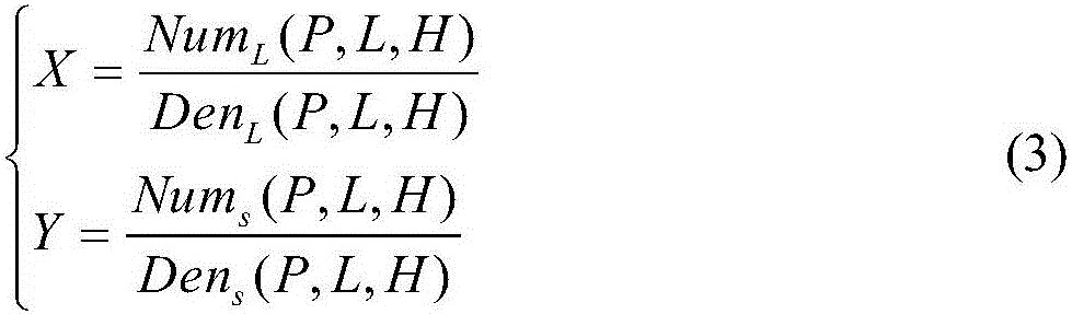
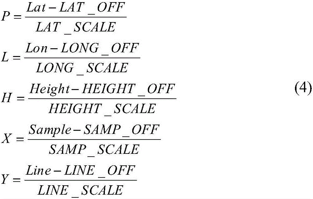
[0027] (1) Assuming that the positive calculation formula of the strict imaging geometric model of SAR satellite remote sensing images is as follows:

[0028] (Lat,Lon)=T(Sample,Line,Height) (1)

[0029] In the formula, T represents the conversion relationship of the latitude and longitude coordinates (Lat, Lon) calculated from the image coor...


PUM


Abstract

The invention belongs to the technical field of surveying science, and particularly discloses a steady parameter estimation method of a rational function model of a satellite remote sensing image. The method comprises the steps that a control point grid and a check point grid are established in the image coverage range by using a strict imaging geometric model and a global DEM; linearization is conducted on the RFM with parameters of the RFM serving as unknown numbers to obtain an error equation coefficient matrix, QR decomposition is conducted on the error equation coefficient matrix through the Householder conversion method, and a new parameter resolving equation is established; parameter resolving is conducted on the equation through the Levenberg-Marquardt method to obtain the needed parameters of the RFM; image coordinates corresponding to object space coordinates of the check point grid are calculated through the resolved RFM, the image coordinates are compared with original image coordinates in the check point grid, maximum errors, minimum errors and mean square errors in the row direction and the list direction of the image are counted, and the fitting precision of the model is estimated. By means of the method, the fitting precision which is superior to that obtained through the ridge estimation algorithm can be achieved.

Description

technical field [0001] The invention relates to the field of surveying and mapping science and technology, in particular to a method for estimating the parameters of the rational function model of a robust satellite remote sensing image. , unbiased and exact estimates. Background technique [0002] With the rapid development of earth observation technology, different types of sensors such as optical and SAR are constantly emerging. In order to realize the high-precision information extraction of satellite remote sensing images, it is very important to establish an accurate geometric positioning model of satellite remote sensing images. Rational Function Model (RFM), as a general sensor imaging model, is simple in form, fast in calculation, more general and confidential. At present, many remote sensing satellite operators provide corresponding RFM parameters when providing data. It is of great significance to study the robust and unbiased estimation method of RFM model par...

Claims


Application Information

Patent Timeline
Patent Type & Authority Patents(China)
IPC IPC(8): G06F19/00
Inventor 吴颖丹郑列朱永松朱莹
Owner HUBEI UNIV OF TECH
Why Eureka
Try Eureka