Method for obtaining spatial data servitization facing geographic information application

A technology of spatial data and acquisition methods, applied in the field of geographic information, to achieve the effect of a wide range of grammar parsing rules expression

Inactive Publication Date: 2013-04-24
CHINA NAT INST OF STANDARDIZATION
View PDF1 Cites 14 Cited by
  • Summary
  • Abstract
  • Description
  • Claims
  • Application Information

AI Technical Summary

Problems solved by technology

[0003] In the traditional geographic information spatial data access and query metho

Method used


Image

  • Method for obtaining spatial data servitization facing geographic information application
  • Method for obtaining spatial data servitization facing geographic information application
  • Method for obtaining spatial data servitization facing geographic information application

Examples


Embodiment Construction

[0016] The method of the present invention will be further described in detail below in conjunction with the accompanying drawings and embodiments of the present invention.

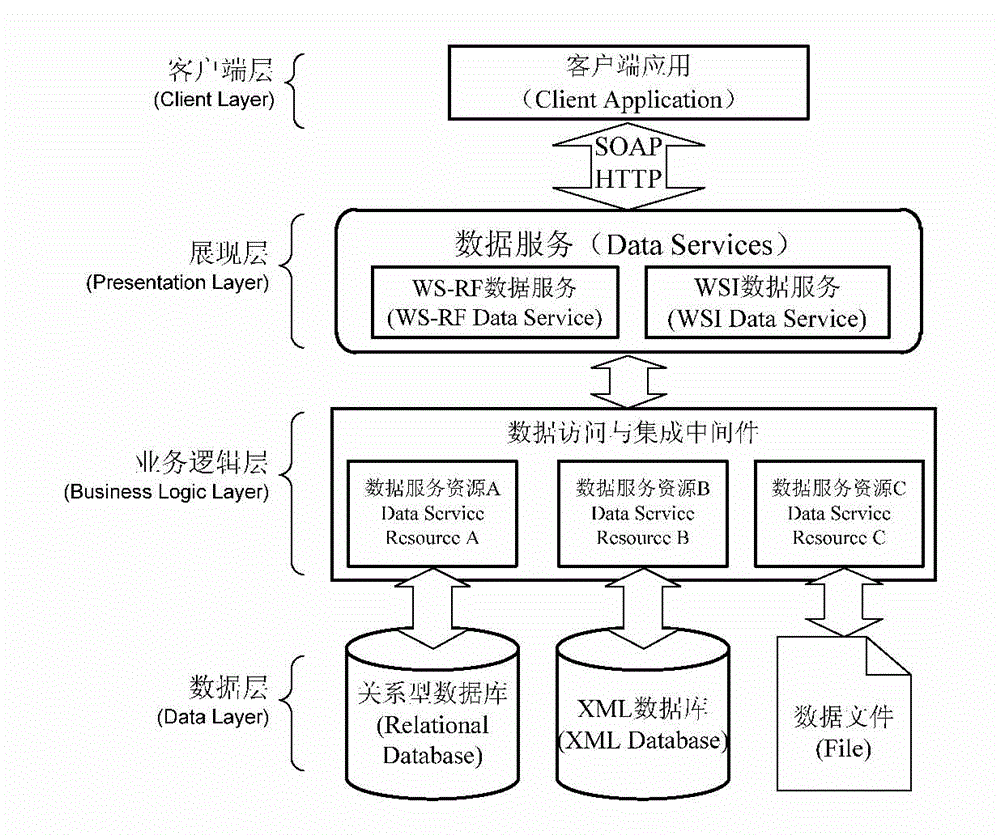
[0017] figure 1 A schematic diagram of a hierarchical model for spatial data access and acquisition; such as figure 1 As shown, a customized service-centric model architecture is built for the grid computing environment, and the computing and storage resources at different levels are virtualized to span the Multiple distributed nodes integrate and collaborate on resources.

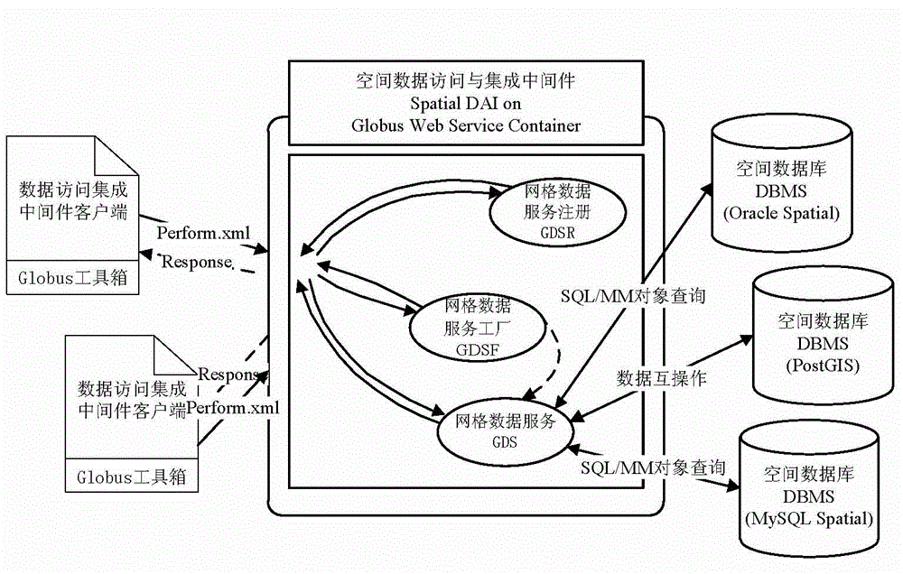
[0018] Spatial data access and acquisition middleware integrates distributed heterogeneous data file resources and relational databases into the grid environment, follows the standard message format of network services, and establishes an interactive channel for data requests and responses between the server and the client. In addition to the data access and update functions, the middleware supports expansion through custom executio...


PUM


Abstract

The invention discloses a method for obtaining spatial data servitization facing geographic information application. The method includes: the spatial data servitization is inquired; a query execution plan is obtained; a spatial processing object query language enables a spatial query function conforming to a structured query language multimedia (SQL/MM) extensions framework rule to be nested in an object query, a query statement is analyzed through a distributed query execution engine, the spatial query function is transferred to a relational database with spatial expansion at the rear end to be executed, the query statement submits query retrieval to the database through data service, and distributed query results are collected to be returned to a data service requester. The method for obtaining the spatial data servitization facing the geographic information application can successfully response to continuously updated heterogeneous mass data resource access queries and enhances query retrieval efficiency of geographic information data through the query statement packaged in object query mode.

Description

technical field [0001] The invention relates to geographic information technology in the field of information, in particular to a method for spatial data service query and acquisition oriented to geographic information applications. Background technique [0002] The acquisition of geographic information data in the network service environment, technical innovation is carried out in the mode of direct connection between the traditional client and the geospatial database for data query, and the spatial data resource is accessed by the middleware specially responsible for query processing in the way of data service With query retrieval, the sharing and interoperability of geospatial data resources is realized through data service integration. The spatial data service acquisition method for geographic information applications provides an interface for spatial data access and query through the service release of data resources. While shielding the back-end complex heterogeneous...

Claims


Application Information

Patent Timeline
IPC IPC(8): G06F17/30
Inventor 高昂
Owner CHINA NAT INST OF STANDARDIZATION
Why Eureka
Try Eureka