
A sins/cns integrated navigation system and navigation method based on comprehensive optimal correction

An integrated navigation system and integrated navigation technology, applied in directions such as navigation through speed/acceleration measurement, astronomical navigation, etc., can solve problems such as inability to apply aircraft

Inactive Publication Date: 2015-10-28
BEIHANG UNIV
View PDF2 Cites 0 Cited by
  • Summary
  • Abstract
  • Description
  • Claims
  • Application Information

AI Technical Summary

Problems solved by technology

However, the traditional astronomical navigation method based on starlight refraction and indirect sensitivity to the horizon requires the orbital dynamics model of the aircraft, which cannot be applied to high-altitude and long-endurance aircraft

Method used


Image

  • A sins/cns integrated navigation system and navigation method based on comprehensive optimal correction
  • A sins/cns integrated navigation system and navigation method based on comprehensive optimal correction
  • A sins/cns integrated navigation system and navigation method based on comprehensive optimal correction

Examples


Embodiment Construction

[0117] The present invention will be further described in detail below in conjunction with the accompanying drawings.

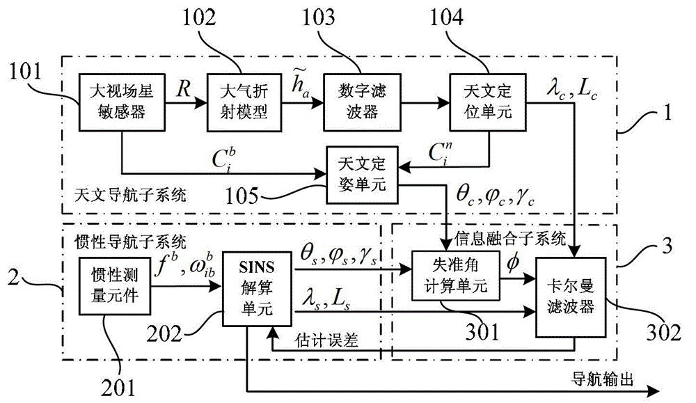
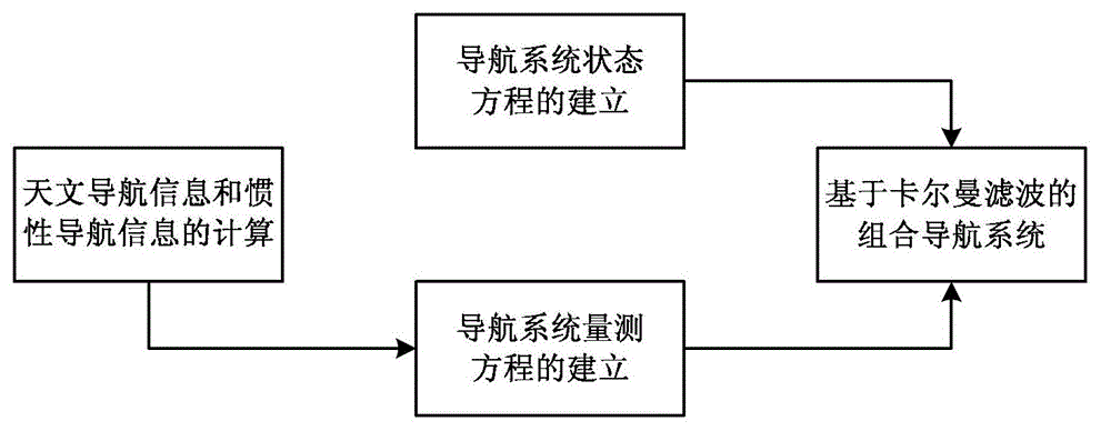
[0118] The invention proposes a comprehensive optimal correction-based SINS / CNS integrated navigation system and its navigation method. The system state equation is established according to the error equation of SINS; the astronomical position information (L c ,λ c ), astronomical attitude information (θ c , gamma c ) and inertial position information (L s ,λ s ), inertial attitude information (θ s , gamma s ) to output structural observations; use the Kalman filter algorithm to estimate and correct navigation errors to improve the accuracy of the integrated navigation system.

[0119] See figure 1 , the present invention proposes a comprehensive optimal correction based SINS / CNS integrated navigation system, including astronomical navigation subsystem 1, inertial navigation subsystem 2 and information fusion subsystem 3;

[0120] The celestial n...


PUM


Abstract

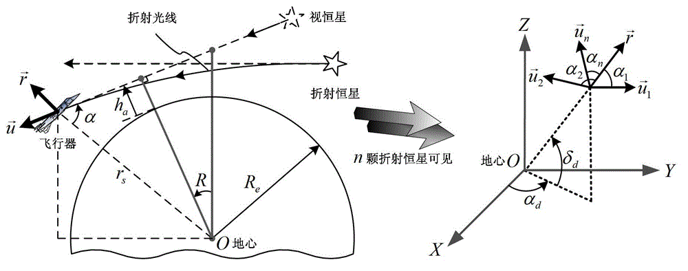
The invention provides an SINS / CNS integrated navigation system based on comprehensive optimal correction and a navigation method thereof, and belongs to the technical field of integrated navigation. The integrated navigation system comprises an astronavigation subsystem, an inertia navigation subsystem and an information fusion subsystem. The navigation method comprises the following steps: analyzing celestial fix based on starlight refraction, building up navigation system state equations, building up navigation system measuring equations and performing information fusion of an integrated navigation system based on Kalman filtering. According to the invention, by utilizing the basic principle of starlight refraction indirection sensitive horizon and a large viewing field star sensor, the characteristics of a plurality of fixed stars can be observed at the same time, and the starlight refraction indirection sensitive horizon method is applied to aircrafts that do not fulfill track kinetics, so that the problem of high-precision autonomous horizon of the celestial navigation system is solved. According to the invention, position and posture information of the celestial navigation system are fully utilized to perform comprehensive optimal correction on the SINS deviation, so that the integrated navigation accuracy is significantly improved.

Description

technical field [0001] The invention relates to a comprehensive optimal correction-based SINS / CNS integrated navigation system and a navigation method thereof, belonging to the technical field of integrated navigation. Background technique [0002] Due to the long flight distance and long flight time of high-altitude and long-endurance aircraft, high requirements are placed on navigation accuracy. At present, the navigation systems suitable for high-altitude and long-endurance aircraft mainly include strapdown inertial navigation system (SINS), GPS, celestial navigation system (CNS), terrain matching navigation system (TAN) and Doppler navigation system. [0003] Strapdown inertial navigation system is a completely autonomous navigation technology, which has the advantages of high short-term accuracy, continuous output, strong anti-interference ability, and complete navigation information. However, its navigation error accumulates over time, and it is difficult to work inde...

Claims


Application Information

Patent Timeline
Patent Type & Authority Patents(China)
IPC IPC(8): G01C21/02G01C21/16
Inventor 王新龙金光瑞
Owner BEIHANG UNIV
Learn More