Layering collocation method of land utilization
A technology of hierarchical allocation and land, applied in data processing applications, instruments, calculations, etc., can solve the problems of difficult land use coordination results, lack of participation of multi-stakeholder groups, etc., to achieve good practicability and improve rationality.
- Summary
- Abstract
- Description
- Claims
- Application Information
AI Technical Summary
Problems solved by technology
Method used
Image
Examples
Embodiment
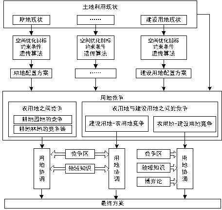
[0045] The schematic diagram of the model of the present invention is as figure 1 , including the following steps:
[0046] Step 1. Obtain and collect basic land use data, including land use status data, terrain data, basic farmland protection data and ecological land use data, and collect relevant statistical yearbook data, and evaluate the suitability of the land types that need to be optimized for spatial layout. The spatial data is converted into a grid form with a certain precision.
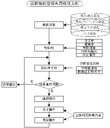
[0047] Step 2, using the genetic algorithm to optimize the spatial layout of each local category, the process of optimizing the spatial layout of a certain land category is as follows: figure 2 As shown, the detailed steps are as follows:
[0048] a, Initialize algorithm parameters and population. Algorithm parameters include mutation rate, crossover rate, population size and end conditions, etc. The chromosome is a two-dimensional grid chromosome, and the grid unit (ie, gene) is all b...
PUM
 Abstract
Description
Claims
Application Information
 - R&D
- Intellectual Property
- Life Sciences
- Materials
- Tech Scout
- Unparalleled Data Quality
- Higher Quality Content
- 60% Fewer Hallucinations
Browse by: Latest US Patents, China's latest patents, Technical Efficacy Thesaurus, Application Domain, Technology Topic, Popular Technical Reports.
© 2025 PatSnap. All rights reserved.Legal|Privacy policy|Modern Slavery Act Transparency Statement|Sitemap|About US| Contact US: help@patsnap.com


