Subdivision pretreatment method and data extraction method used for image data extraction

An image data and preprocessing technology, applied in image data processing, image data processing, electrical digital data processing and other directions, can solve the problems of difficult spatial data resources, low extraction, integration and application efficiency, and achieve the effect of efficient extraction

Inactive Publication Date: 2013-06-12
PEKING UNIV
View PDF1 Cites 19 Cited by
  • Summary
  • Abstract
  • Description
  • Claims
  • Application Information

AI Technical Summary

Problems solved by technology

[0004] This kind of independent remote sensing image data organization and indexing method established by different departments can well meet the needs of the image data extraction business within the department, but if data extraction needs to be performed across departments, for example in the field of spatial information management technology, The information management and update of maps usually requires the aggregation of remote sensing images into map frames to update map data. However, due to the numerous and independent data division methods in the field of spatial information management, data bodies of different sizes are cut out. The extraction, integration and application efficiency of different types of remote sensing data belonging to the same geographical area is extremely low, resulting in difficulties in "sharing", "interoperability" and "smooth migration" of spatial data resources

Method used


Image

  • Subdivision pretreatment method and data extraction method used for image data extraction
  • Subdivision pretreatment method and data extraction method used for image data extraction

Examples


Embodiment Construction

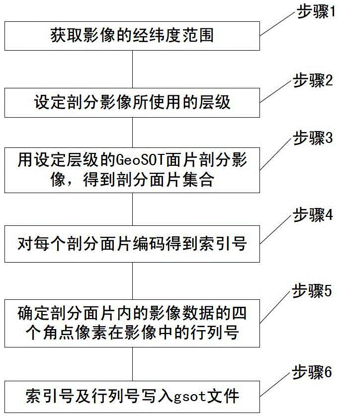
[0028] The present invention will be described in detail below with reference to the accompanying drawings and examples.

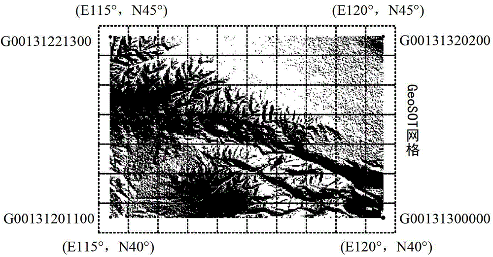
[0029] The subdivision preprocessing method for image data extraction proposed by the present invention is based on the GeoSOT subdivision and coding scheme. For this scheme, refer to the patent application proposed by Peking University: "A method for unifying the existing latitude and longitude subdivision grid" (published No. CN102609525, application date is February 10, 2012), this patent application discloses a GeoSOT geographic grid design scheme, which is used to solve the problem of global geographic space segmentation and identification. The scheme adopts full quadtree recursive subdivision, and subdivides the earth's surface space from the global to the centimeter level with a total of 32 levels. Each GeoSOT subdivision level has its corresponding GeoSOT grid, and the upper and lower levels of the GeoSOT grid The ratio of the areas between is 1 / 4....


PUM


Abstract

The invention discloses a subdivision pretreatment method and a data extraction method used for image data extraction, and belongs to the technical field of geospace information organization and image data processing. The subdivision pretreatment method comprises the following steps: using level setting GeoSOT patches to subdivide a to-be-processed image and obtaining a set of subdivision patches covering the to-be-processed image; using GeoSOT encoding scheme to perform coding for each subdivision patch in the obtained set of subdivision patches, and recording the coded numbers as index numbers; determining the position information of the image data of each subdivision patch in the to-be-processed image; and writing the index number and the position information of the same subdivision patch correspondingly into a subdivision index gsot file. The extraction method comprises the following steps: (1), obtaining gsot files; (2), determining the extraction patch set according to the latitude and longitude range of the extraction image; (3), performing GeoSOT encoding to the extracted patches; (4), using the encoded numbers to perform matching in gsot files, and obtaining line numbers; and (5), extracting and aggregating image blocks according to the row numbers. The method provided by the invention is suitable for organizing and extracting remote sensing image data.

Description

technical field [0001] The invention relates to the technical fields of geospatial information organization and image data processing, in particular to a preprocessing method for establishing a logical mapping between an earth subdivision grid and image data and a data extraction method based on the preprocessing. Background technique [0002] At present, with the continuous enrichment of earth observation methods and the continuous improvement of the ability to obtain spatial information, the remote sensing image data obtained by people is extremely rich, and the abundance of data is accompanied by the rapid development of data services. In the spatial information management system, the classified storage and organizational mapping of remote sensing data is one of the very important contents. [0003] In today's society, the spatial information management system has entered various departments related to remote sensing data. The spatial information management system often d...

Claims


Application Information

Patent Timeline
Patent Type & Authority Applications(China)
IPC IPC(8): G06F17/30G06T1/00
Inventor 程承旗童晓冲宋树华
Owner PEKING UNIV
Why Eureka
Try Eureka