Three-dimensional geographical information system management platform

A geographic information system and management platform technology, applied in the field of 3D geographic information system management platform, can solve the problems of high purchase cost, weak data processing ability, low modeling efficiency, etc., to overcome high purchase cost, strong data processing ability, The effect of high work efficiency

Inactive Publication Date: 2013-06-26
URUMQI TUSHITIANXIA SOFTWARE CO LTD
View PDF4 Cites 15 Cited by
  • Summary
  • Abstract
  • Description
  • Claims
  • Application Information

AI Technical Summary

Problems solved by technology

[0003] In terms of 3D geographic mapping, existing geographic information systems mainly rely on third-party software for later 3D modeling and management. There is no corresponding functional module for geographic information systems, so it is weak in terms of modeling efficiency and data processing
[0004] In the process of realizing the present invention, the inventor found that there are at least defects such as high purchase cost, low modeling efficiency and weak data processing ability in the prior art

Method used


Image

  • Three-dimensional geographical information system management platform
  • Three-dimensional geographical information system management platform
  • Three-dimensional geographical information system management platform

Examples


Embodiment Construction

[0030] The preferred embodiments of the present invention will be described below in conjunction with the accompanying drawings. It should be understood that the preferred embodiments described here are only used to illustrate and explain the present invention, and are not intended to limit the present invention.

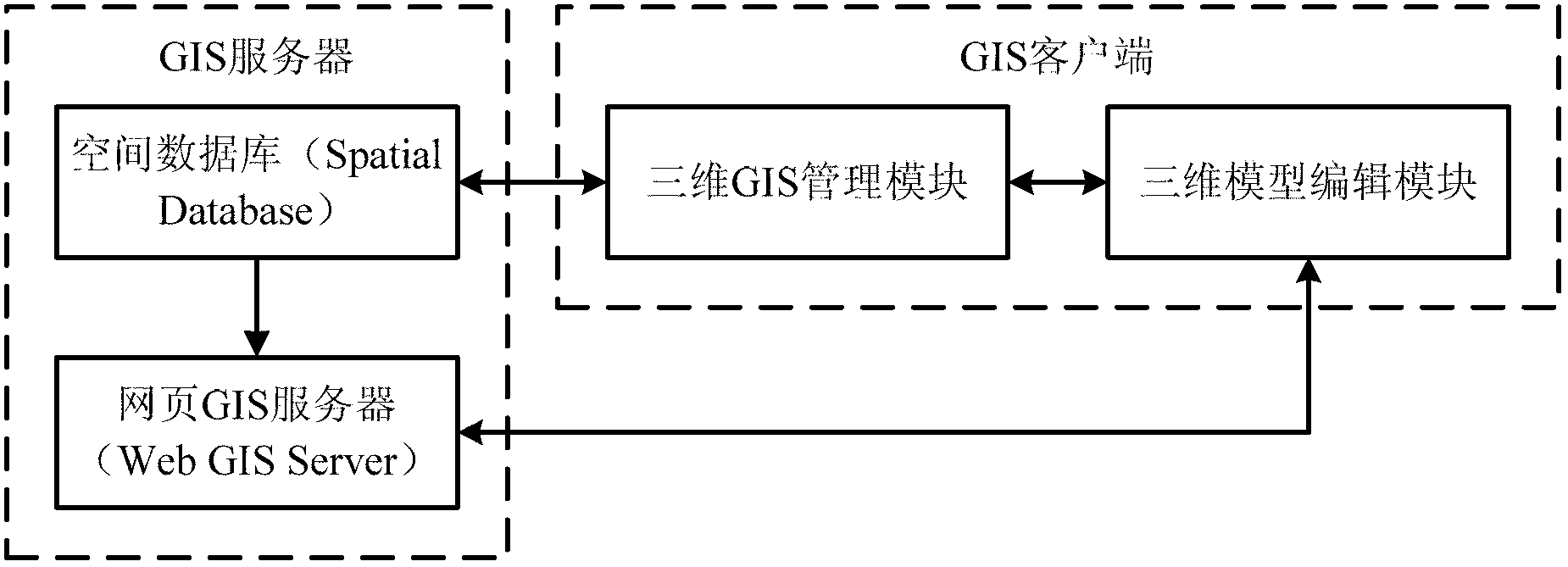
[0031] According to an embodiment of the present invention, such as Figure 1-Figure 7 As shown, a three-dimensional geographic information system management platform is provided. see Figure 1-Figure 5 , the three-dimensional geographic information system management platform of the present embodiment mainly includes a connected GIS server and a GIS client, wherein the GIS server is used to store and update GIS information; the GIS client is used to provide GIS information based on the GIS server , for modeling and management of 3D GIS.

[0032] The above-mentioned GIS server includes a spatial database and a webpage GIS server connected in sequence, and the spati...


PUM


Abstract

The invention discloses a three-dimensional geographical information system management platform which comprises a geographic information system (GIS) server and a GIS client. The GIS server is used for storing GIS information and upgrading the GIS information. The GIS client is used for carrying out modeling and management of a three-dimensional GIS based on the GIS information provided by the GIS server. According to the three-dimensional geographical information system management platform, the defects that in the prior art, purchase cost is high, modeling efficiency is low and data handling capacity is weak are overcome. The advantages of low cost, high working efficiency and strong data handling capacity are achieved.

Description

technical field [0001] The invention relates to the technical field of geographic information systems, in particular to a three-dimensional geographic information system management platform. Background technique [0002] Geographic Information System (Geographic Information System or Geo-Information system, referred to as GIS) is sometimes called "geoscience information system" or "resource and environmental information system". It is a specific and very important spatial information system. It is a technical system that collects, stores, manages, calculates, analyzes, displays and describes the relevant geographical distribution data in the space of the entire or part of the earth's surface (including the atmosphere) with the support of computer hardware and software systems. [0003] In terms of 3D geographic mapping, existing geographic information systems mainly rely on third-party software for later 3D modeling and management. There is no corresponding functional modu...

Claims


Application Information

Patent Timeline
Patent Type & Authority Applications(China)
IPC IPC(8): G06F17/30H04L29/08
Inventor 王以彬
Owner URUMQI TUSHITIANXIA SOFTWARE CO LTD
Why Eureka
Try Eureka