Satellite navigation and inertial measurement combined orbit measuring system and method

An inertial measurement and satellite navigation technology, applied in radio wave measurement systems, satellite radio beacon positioning systems, measurement devices, etc. The effect of magnification and easy data analysis

Active Publication Date: 2013-07-17
SAFEWAY XIAN NAVIGATION TECH
View PDF6 Cites 14 Cited by
  • Summary
  • Abstract
  • Description
  • Claims
  • Application Information

AI Technical Summary

Problems solved by technology

Therefore, people cannot directly extract the irregularity value from the position measurement data, and can only rely on geometric functions and r...

Method used


Image

  • Satellite navigation and inertial measurement combined orbit measuring system and method
  • Satellite navigation and inertial measurement combined orbit measuring system and method
  • Satellite navigation and inertial measurement combined orbit measuring system and method

Examples


Embodiment Construction

[0061] The specific examples of this invention are described below, and the detailed structure refers to the accompanying drawings.

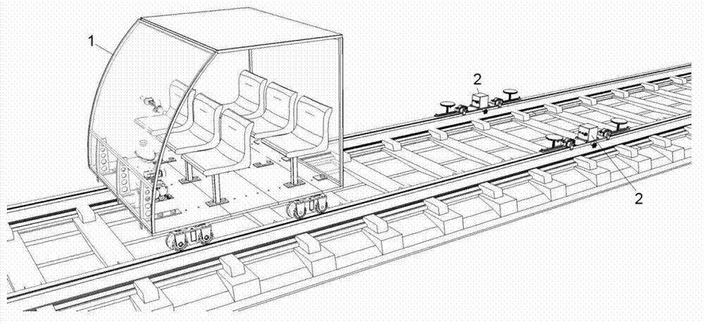
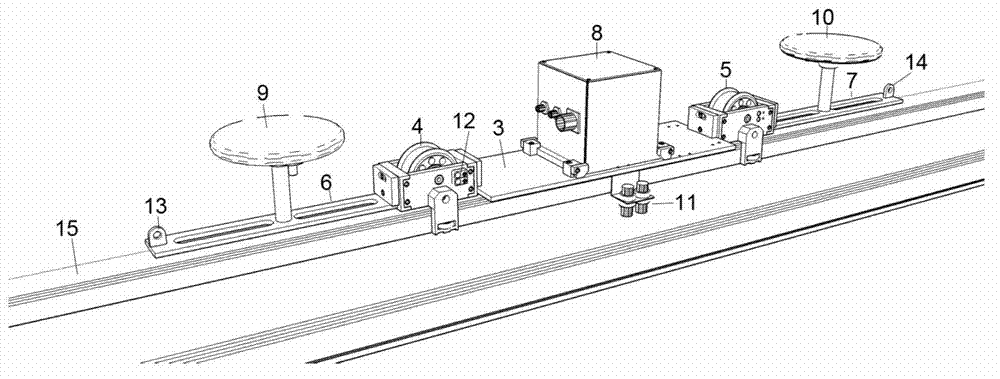
[0062] figure 1 Shown is a schematic diagram of the system structure of the invention, including a measurement unit - two independent satellite navigation and inertial measurement combined equipment: a monorail measuring trolley 2 and a traction device: a portable rail traction trolley 1 and a data post-processing unit, two Two monorail measuring trolleys 2 are respectively placed on the monorail 15, and two monorail measuring trolleys 2 running along the rails are towed by the portable track traction trolley 1, which is used for real-time online measurement and recording of the geometry collected when the relevant equipment runs along the double rails. State and physical state raw data.

[0063] Wherein, the portable rail traction trolley 1 comprises a compartment with open sides, double-track wheels are arranged at the bottom of the compartme...


PUM


Abstract

The invention discloses a satellite navigation and inertial measurement combined orbit measuring system and method. The satellite navigation and inertial measurement combined orbit measuring system comprises a measuring unit and a data post-processing unit. The measuring unit comprises two satellite navigation and inertial measurement combined orbit measuring devices which are placed on two monorails. A drawing device draws a satellite navigation and inertial measurement combined system to perform real-time online measurement, record original data of a dual-rail geometrical state and an equipment running state and perform offline processing through the data post-processing unit. The satellite navigation and inertial measurement combined orbit measuring method comprises performing preprocessing on original measurement data; establishing a directional mileage measurement curve and an ideal curve; calculating absolute and relative irregularity of a rail direction; establishing a slope angle mileage measurement curve and a slope angle ideal curve; and calculating absolute and relative irregularity of the height. According to online data collection, an offline data processing mode and a dual-rail parallel measuring mode, external geometrical information and internal geometrical irregularity of orbits are determined.

Description

technical field [0001] The invention belongs to the technical field of orbit detection, and in particular relates to a system and a measurement method for detecting the outer geometric shape and inner irregularity of an orbit by using GPS, Beidou, GLONASS, Galileo and other satellite navigation and inertial measurement combined systems. Background technique [0002] For high-speed railways, the external geometry and high internal smoothness of the track are the key to ensure the fast, stable, comfortable, safe and economical operation of the train. Maintaining high track smoothness is the purpose of high-speed rail track maintenance, and precise detection of track irregularities is the key to track maintenance. At present, the strict requirements of high-speed railways on testing equipment have exceeded the capabilities of traditional testing equipment, and the technical lag of testing equipment has become a bottleneck hindering the sustainable and healthy development of my ...

Claims


Application Information

Patent Timeline
IPC IPC(8): G01S19/50G01S19/49
Inventor 韩云飞
Owner SAFEWAY XIAN NAVIGATION TECH
Why Eureka
Try Eureka