Orthorectification method of non-control satellite-borne SAR (synthetic aperture radar) image based on inverted RD positioning model

An orthorectification and image technology, which is applied in the field of synthetic aperture radar (SAR) image processing and image geometric correction processing, can solve problems such as difficult parallel programming, reduction of calculation amount, difficult engineering batch production, etc., and achieve easy parallelization processing, improving correction efficiency, and reducing image distortion

Active Publication Date: 2013-07-24
济钢防务技术有限公司
View PDF4 Cites 14 Cited by
  • Summary
  • Abstract
  • Description
  • Claims
  • Application Information

AI Technical Summary

Problems solved by technology

[0011] 1. Empirical formulas are needed to simulate SAR scattering characteristics, but empirical formulas lack universality and are difficult to use in engineering mass production;
[0012] 2. Using DEM data to simulate SAR images can only adapt to mountainous areas with severe terrain fluctuations. For spaceborne SAR images with a wide coverage area that has both flat areas and complex terrain fluctuations, the

Method used


Image

  • Orthorectification method of non-control satellite-borne SAR (synthetic aperture radar) image based on inverted RD positioning model
  • Orthorectification method of non-control satellite-borne SAR (synthetic aperture radar) image based on inverted RD positioning model
  • Orthorectification method of non-control satellite-borne SAR (synthetic aperture radar) image based on inverted RD positioning model

Examples


specific Embodiment approach

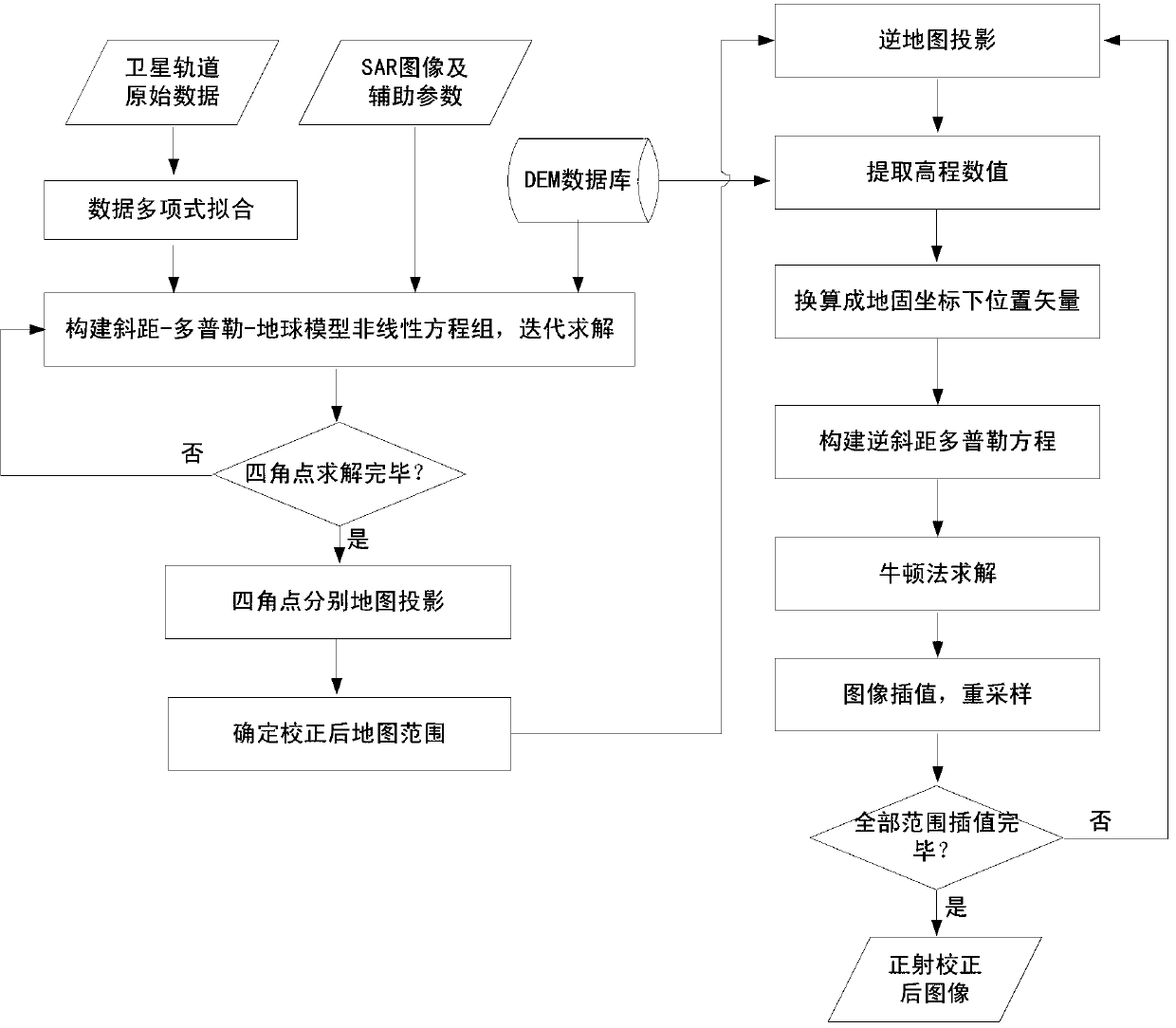
[0042] Firstly, the relevant parameters required by the present invention are extracted from the product. Include the following parameters and several sets of satellite position velocity vectors.

[0043]

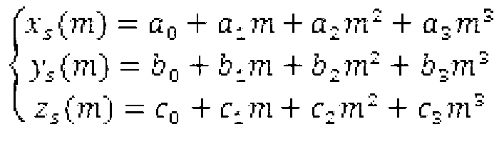
[0044] Step 1: Carry out polynomial fitting on the satellite orbit data with pixels as the independent variable, and obtain the relationship between the satellite position velocity and the image azimuth pixel;

[0045] a 0 -1882349.705302733 b 0 5030621.015380397 c 0 4289948.518499875 a 1 3211.325617072 b 1 -3811.343856856 c 1 5858.518584492 a 2 1.298738241 b 2 -3.181818766 c 2 -2.587766992 a 3 -0.047247270 b 3 -0.015512607 c 3 -0.011412460

[0046] The second step: use the satellite orbit position corresponding to the pixel obtained in the first step to construct the slope-range Doppler equation group, and solve it iteratively, so as to perform pixel positioning on the four corner points of the SAR image, and obta...


PUM


Abstract

The invention provides an orthorectification method of a non-control satellite-borne SAR (synthetic aperture radar) image based on an inverted RD positioning model. By the method, the problem that ground height values need to be iteratively acquired in the prior art can be solved; the orthorectification process of the SAR image is easy for multiple programming; and the processing efficiency is improved on the basis of ensuring the geometric correction precision. The method comprises the following steps of firstly constructing a slant distance doppler equation set to obtain geography latitude and longitude of four points by using satellite orbit positions corresponding to pixels; then mapping a map to obtain the east coordinate and north coordinate of the four points and the needed image map range; mapping an inverse map to obtain the geography latitudes and longitudes of the pixels; converting into position vectors of the pixels under a ground-fixed coordinate system; finally resampling gray values of the needed image pixels by using a bilinear interpolation method; and obtaining the corresponding gray values until all pixels in the needed image map range are calculated, thereby obtaining the corrected image.

Description

technical field [0001] The invention relates to an orthorectification method for an uncontrolled spaceborne SAR image based on an inverse RD positioning model, and relates to the fields of synthetic aperture radar (SAR) image processing and image geometry correction processing. Background technique [0002] With the successful launch of high-resolution new SAR sensor satellites (such as TerraSAR-X, RadarSAT-2, etc.), their role in national economic construction has become more and more prominent. However, due to the special slant-range imaging mechanism of SAR, the geometric distortion caused by terrain fluctuations is large, and the positioning error is serious, which leads to difficulties in quantitative geometric analysis and image interpretation, which largely limits its application in surveying and mapping, forestry, and geological disasters. applications in the field of prevention. Therefore, there is a wide range of application requirements and great technical diffic...

Claims


Application Information

Patent Timeline
IPC IPC(8): G06T5/00
Inventor 刘佳音仇晓兰胡玉新雷斌付琨
Owner 济钢防务技术有限公司
Why Eureka
Try Eureka