Beidou navigation self-optimizing method

A Beidou navigation and optimization method technology, applied in the field of navigation, can solve the problems of insufficient usability, insufficient navigation function experience, insufficient navigation and positioning accuracy, etc., and achieve the effect of enhancing signal detection accuracy, wide signal coverage, and improving detection capabilities.

Active Publication Date: 2014-12-24
JIANGSU PROVINCIAL COMM PLANNING & DESIGN INST +1
View PDF6 Cites 0 Cited by
  • Summary
  • Abstract
  • Description
  • Claims
  • Application Information

AI Technical Summary

Problems solved by technology

[0004] The existing Beidou positioning platform is mainly used for information service management and command and dispatch center to realize remote positioning monitoring and management of Beidou vehicle-mounted or ship-borne navigation and positioning terminals and Beidou navigation mobile terminals. It has not yet been completed, and it cannot achieve full coverage and high-precision navigation and positioning. Because the construction of the ground segment of the Beidou navigation system is still in progress, the various navigation and positioning information transmitted and adjusted by the ground station has yet to be improved. Now the coverage of the Beidou navigation system Not wide enough, usability is not high enough, continuity is poor, navigation and positioning accuracy is not enough
When the existing Beidou navigation and positioning terminal and Beidou positioning platform provide positioning and navigation services and remote positioning monitoring and management, Beidou signal strength detection and feedback cannot be performed. For areas where the Beidou signal is weak or the Beidou signal is shielded, the existing Beidou navigation The positioning terminal is also unable to perform effective self-optimization, so that the current Beidou navigation and positioning terminal does not provide users with a good enough navigation experience, and the existing Beidou positioning platform cannot count and detect the Beidou signal strength of the Beidou positioning and navigation terminal. Unable to provide powerful data collection for the trial operation of the Beidou navigation system

Method used


Image

  • Beidou navigation self-optimizing method
  • Beidou navigation self-optimizing method
  • Beidou navigation self-optimizing method

Examples


Embodiment Construction

[0038] The present invention will be specifically introduced below in conjunction with the accompanying drawings and specific embodiments.

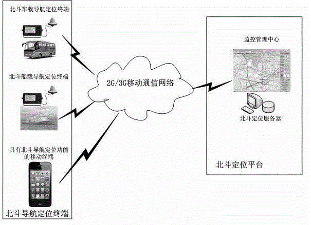
[0039] figure 1 It is the framework of Beidou navigation and positioning terminal and Beidou positioning platform described in the present invention.

[0040] Such as figure 1 As shown: the Beidou navigation and positioning terminal transmits the positioning information to the Beidou positioning platform through various mobile communication technologies. and management.

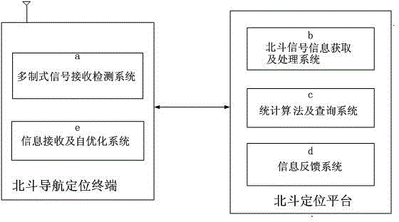
[0041] Fig. 2 is a schematic structural diagram of a Beidou navigation self-optimization device according to the present invention.

[0042] Such as figure 2As shown: a Beidou navigation self-optimization device, including a Beidou navigation and positioning terminal and a Beidou positioning platform connected to each other. The Beidou navigation and positioning terminal includes a multi-standard signal receiving and detecting system a and an information receiving...


PUM


Abstract

The invention discloses a Beidou navigation self-optimizing device and a self-optimizing method of the Beidou navigation self-optimizing device, wherein the self-optimizing device comprises a Beidou navigation positioning terminal and a Beidou positioning platform in mutual communication, the Beidou navigation positioning terminal comprises a multisystem type signal receiving detection system and an information receiving and self-optimizing system, and the Beidou positioning platform comprises a Beidou signal information obtaining and processing system, a statistic algorithm and inquiry system and an information feedback system. The Beidou navigation self-optimizing device and the self-optimizing method have the advantages that the detection capability of the positioning platform on Beidou signals of the Beidou navigation positioning terminal can be improved, in addition, the regional statistics can be carried out by combining the geographical position and the Beidou signal intensity, the self-optimization of the Beidou navigation positioning terminal can be realized through signal detection and information feedback, the requirement on Beidou satellite signals is reduced, the terminal fitness is improved, and the geographic position information continuity and the signal detection precision under the condition of unstable Beidou signals are enhanced.

Description

technical field [0001] The invention relates to a Beidou navigation self-optimization device and a self-optimization method thereof capable of improving the continuity of Beidou-based navigation and positioning terminal signal detection and navigation accuracy, and belongs to the field of navigation technology. Background technique [0002] The main principle of satellite positioning technology is to place a GPS receiver at an undetermined position on the ground, and receive signals transmitted by more than 4 GPS satellites at the same time. The positions of the four or more satellites at this moment and their respective distances to the receiver are determined by a certain method, and the position of the test point and the clock error of the receiver are calculated by using the distance intersection method. [0003] The Beidou Navigation Satellite System (BeiDou Navigation Satellite System) is an independently developed and independently operated global satellite navigation...

Claims


Application Information

Patent Timeline
Patent Type & Authority Patents(China)
IPC IPC(8): G01S19/33
Inventor 纪蓉季锦章臧正保刘轰王维锋明小梅
Owner JIANGSU PROVINCIAL COMM PLANNING & DESIGN INST
Why Eureka
Try Eureka