A method for multiplying positioning precision in a satellite navigation positioning system

A positioning system and satellite navigation technology, applied in the field of satellite navigation and positioning, can solve problems such as inability of user terminal positioning accuracy and estimation, and achieve the effect of improving navigation and positioning performance and positioning accuracy

Active Publication Date: 2013-10-23
NAT ASTRONOMICAL OBSERVATORIES CHINESE ACAD OF SCI
View PDF5 Cites 16 Cited by
  • Summary
  • Abstract
  • Description
  • Claims
  • Application Information

AI Technical Summary

Problems solved by technology

[0006] In general, the pseudo-range measurement values ​​of multiple carrier frequency points of the same navigation satellite and the satellite ephemeris have related parts, at this time the positioning accuracy of the user terminal cannot be estimated by formula (1); at the same time, in the existing global satellite In the navigation and positioning system, the number of carrier frequency points that each navigation satellite can downlink at the same time is not the same, and the invention cannot be simply applied: the method for reducing the pseudo-range measurement error in the multi-carrier positioning method in satellite navigation (patent application number: 201110228917.3)

Method used


Image

  • A method for multiplying positioning precision in a satellite navigation positioning system
  • A method for multiplying positioning precision in a satellite navigation positioning system
  • A method for multiplying positioning precision in a satellite navigation positioning system

Examples


Embodiment Construction

[0021] In order to make the object, technical solution and advantages of the present invention clearer, the present invention will be described in further detail below in conjunction with specific embodiments and with reference to the accompanying drawings.

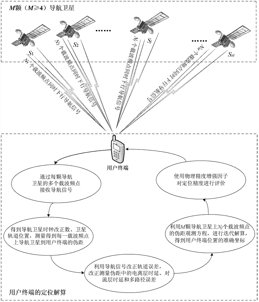
[0022] figure 1 It is a flowchart of a method for doubling the positioning accuracy in the satellite navigation and positioning system of the present invention. like figure 1 As shown, the method for doubling positioning accuracy in a satellite navigation and positioning system proposed by the present invention specifically includes the following steps:

[0023] Step 1, each of the M (M≥4) navigation satellites in the satellite navigation and positioning system will transmit the navigation signal for navigation and positioning to the user terminal to be positioned to multiple carrier frequency points , the navigation signal includes a pseudo-random noise code, navigation text and wide-area enhancement information;

[0...


PUM


Abstract

The invention discloses a method for multiplying positioning precision in a satellite navigation positioning system. In the method, each navigational satellite in the satellite navigation positioning system downloads pseudo stochastic noise codes, navigation messages, and wide-area enhanced information via multiple carrier frequency points; a user terminal measures and corrects the track errors of the navigational satellites, ionosphere time delay, troposphere time delay, and multipath errors simultaneously and individually with the multiple carrier frequency points in order to achieve pseudo range measurement between the navigational satellites and the user terminal on the multiple carrier frequency points; and by using a pseudo range observational equation of the multiple carrier frequency points, the accurate coordinate of the position of the user terminal can be calculated via iterative computations. The method is capable of well increasing the positioning precision of the user terminal and substantially improving the navigation positioning performance of the satellite navigation positioning system.

Description

technical field [0001] The invention relates to satellite navigation and positioning technology, in particular to a method for doubling the positioning accuracy in a satellite navigation and positioning system, which is applicable to a navigation satellite that can simultaneously downlink multiple carrier frequency points and modulate pseudo-random noise codes and multi-frequency navigation messages. satellite navigation system. Background technique [0002] In the satellite navigation and positioning system, the positioning accuracy of the user terminal is mainly determined by the spatial layout of the system constellation and the equivalent pseudo-range measurement error. Usually, the positioning error of the satellite navigation and positioning system can be described by the following formula: [0003] σ i = DOP i ·σ UERE (1) [0004] Among them, σ i is the positioning error of the user terminal, i=1, 2, 3, 4, and 5 correspond to the plane, elevation, position, ...

Claims


Application Information

Patent Timeline
Patent Type & Authority Applications(China)
IPC IPC(8): G01S19/24
Inventor 艾国祥马利华施浒立季海福
Owner NAT ASTRONOMICAL OBSERVATORIES CHINESE ACAD OF SCI
Why Eureka
Try Eureka