Panoramic map database acquisition system and vision-based positioning and navigating method

A technology of panoramic map and collection system, applied in the field of navigation and positioning, can solve problems such as low accuracy, slow GPS positioning speed, and inability to complete positioning, and achieve the effect of high accuracy and improved user experience.

Active Publication Date: 2013-11-20
CHENGDU IDEALSEE TECH
View PDF6 Cites 91 Cited by
  • Summary
  • Abstract
  • Description
  • Claims
  • Application Information

AI Technical Summary

Problems solved by technology

GPS positioning can provide users with a lot of auxiliary information for outdoor positioning and navigation, but it also has obvious defects, th

Method used


Image

  • Panoramic map database acquisition system and vision-based positioning and navigating method

Examples


Embodiment Construction

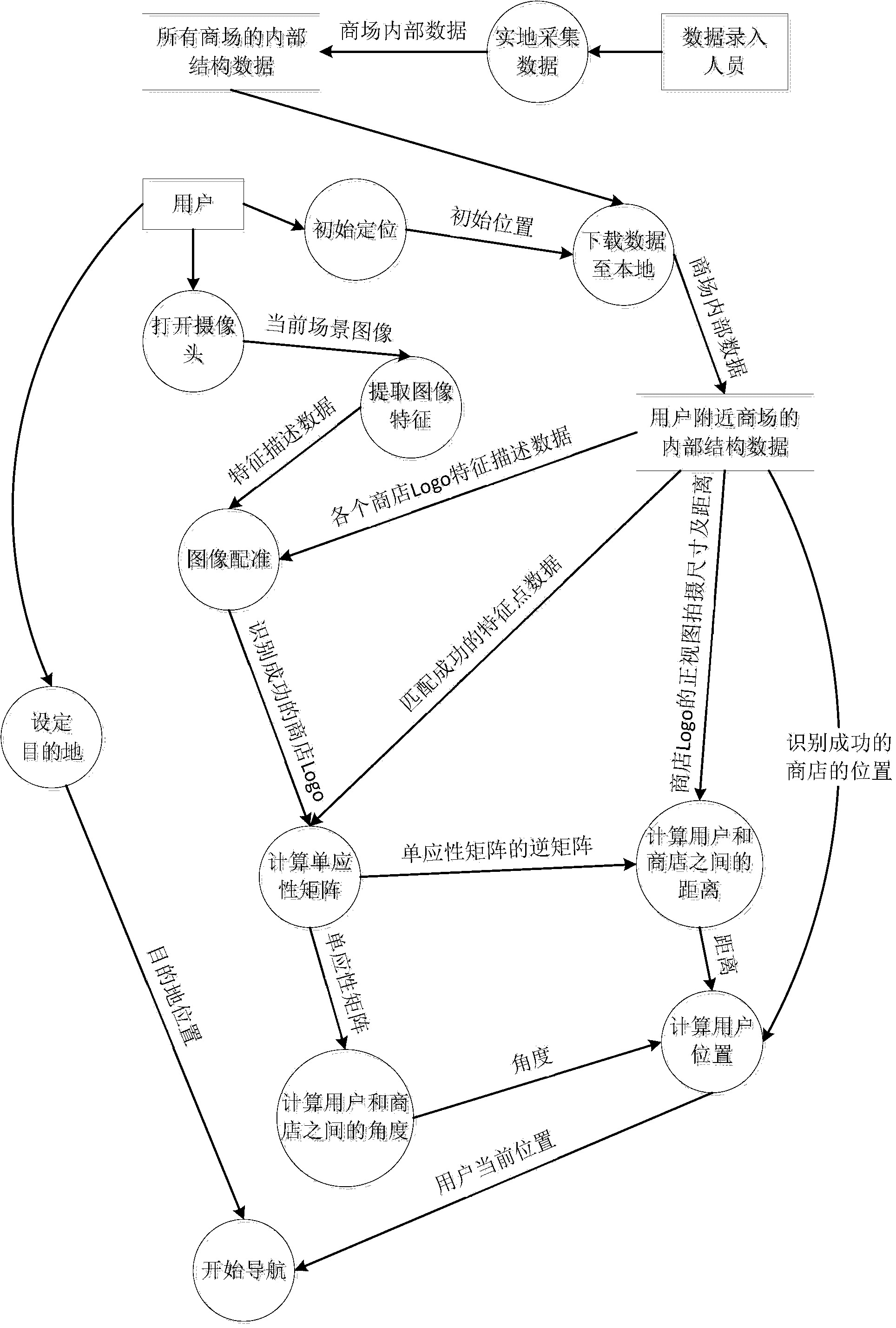
[0041] The following will clearly and completely describe the technical solutions in the embodiments of the present invention with reference to the accompanying drawings in the embodiments of the present invention. Obviously, the described embodiments are only some, not all, embodiments of the present invention. Based on the embodiments of the present invention, all other embodiments obtained by persons of ordinary skill in the art without creative efforts fall within the protection scope of the present invention.

[0042] The present invention uses the positioning technology based on image recognition to locate the user's own position, and finds the shortest route from the user's current position to the target position selected by the user according to the routing algorithm, and displays the calculated shortest route on the electronic map or uses a virtual Arrows combined with real-world maps give hints.

[0043] Since the present invention adopts the positioning technology b...


PUM


Abstract

The invention discloses a panoramic map database acquisition system and a vision-based user location positioning and navigating method. A user shoots surrounding symbolic images by a mobile phone, and self-location positioning and live-action map navigation can be completed through image feature identification and rectification, so that a novel navigation mode which is accurate in positioning and fresh in experience is provided. The system and the method have a more obvious effect when used in indoor environment. Besides, the panoramic map navigation manner is adopted, accordingly, the most visual live-action navigation experience is provided for the user, and the user experience can be greatly improved.

Description

technical field [0001] The invention relates to the field of navigation and positioning, in particular to a panorama map database acquisition system and a vision-based positioning and navigation method. Background technique [0002] In recent years, the application of LBS (Location Based Service, location-based service) has gradually become a hot spot, and the navigation technology has developed rapidly. GPS positioning can provide users with a lot of auxiliary information for outdoor positioning and navigation, but it also has obvious defects, that is, in the indoor environment, GPS positioning speed is extremely slow, and the accuracy is low, and even the positioning cannot be completed. Indoor navigation technology has gradually become a research hotspot. In the existing technology, indoor navigation technology mainly uses wireless WIFI, radio frequency identification, geomagnetic field and other technologies for positioning. [0003] With the continuous advancement of s...

Claims


Application Information

Patent Timeline
IPC IPC(8): G01C21/30G06F17/30G01C21/34
Inventor 宋海涛柳寅秋
Owner CHENGDU IDEALSEE TECH
Why Eureka
Try Eureka