An Aircraft Return Route Planning Method Based on Online Composition

A return route and aircraft technology, applied to navigation through speed/acceleration measurement, integrated navigator, etc., can solve problems such as many constraints and difficulties in establishing mathematical models, and achieve the effects of reducing difficulty, high measurement accuracy, and reducing efficiency

Active Publication Date: 2016-03-02
BEIJING AEROSPACE AUTOMATIC CONTROL RES INST +1
View PDF3 Cites 1 Cited by
  • Summary
  • Abstract
  • Description
  • Claims
  • Application Information

AI Technical Summary

Problems solved by technology

[0010] Due to the many constraints involved in aircraft trajectory planning, there are certain difficulties in establishing mathematical models, and it involves the processing of a large amount of different information. issues to be resolved

Method used


Image

  • An Aircraft Return Route Planning Method Based on Online Composition
  • An Aircraft Return Route Planning Method Based on Online Composition
  • An Aircraft Return Route Planning Method Based on Online Composition

Examples


Embodiment Construction

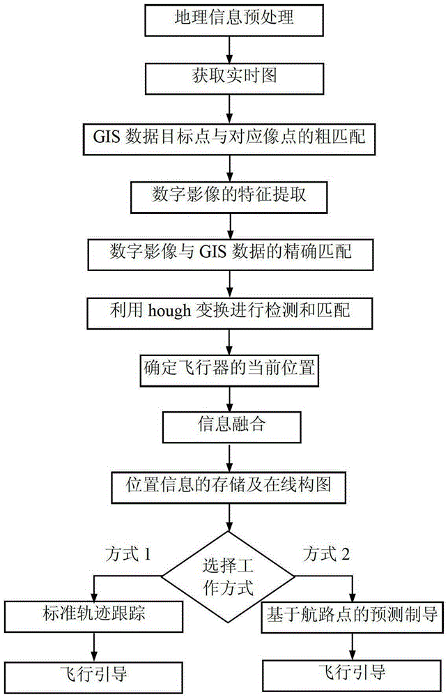
[0036] Below in conjunction with accompanying drawing, the present invention is described in detail, and the main workflow of the present invention is as follows figure 1 As shown, the specific implementation method is:

[0037] (1) Select a series of typical areas on the scheduled flight route of the aircraft, and store the geographical information on the entire flight route or only the selected typical areas in advance in the on-board computer;

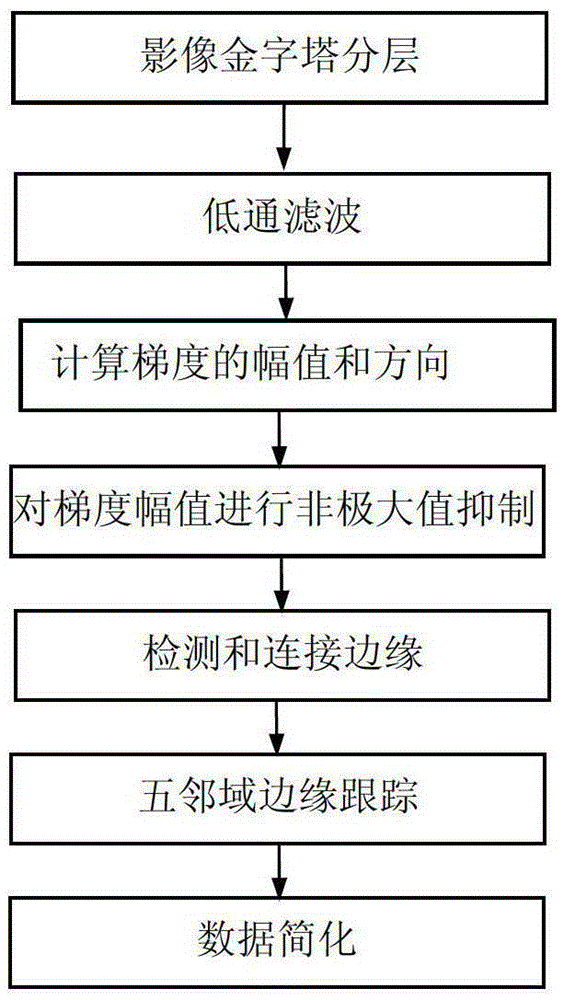
[0038] Before the geographic information is stored in the onboard computer, the geographic data can be pre-processed according to the requirements of the matching algorithm, mainly including three processes of data simplification, feature extraction, and data fusion.

[0039] The specific steps of preprocessing are as follows:

[0040] (1.1) Extract geographic targets that can be used for matching positioning from geographic information data in typical areas;

[0041] Geographic Information System (GIS) often strives for the compl...


PUM


Abstract

An online composition based aircraft return route programming method comprises the following steps: 1, plotting the geographic information of a whole flight line or only a selected typical area, and storing the geographic information in an airborne computer; 2, obtaining the inertial navigation information of an aircraft in real time; 3, obtaining a real time graph; 4, determining the current flight position; 5, estimating the inertial navigation error, and utilizing the estimated inertial navigation error to correct the navigation parameter of the aircraft; 6, storing the information-fused aircraft position information obtained in step 5 in the geographic information of the airborne computer according to a preset rule by the airborne computer in the aircraft flight process, and carrying out online composition of the information-fused aircraft position information; and 7, carrying out real-time track programming according to the online composition result and the task characteristic of the aircraft in the aircraft return process to complete flight guiding.

Description

technical field [0001] The present invention belongs to the category of autonomous navigation and track planning technology. Specifically, it adopts the INS / GIS combined navigation method, and realizes the autonomous navigation of drones, air vehicles and other aircraft by using geographic information system (GIS for short) and online composition technology. Quickly plan navigation and return routes. Background technique [0002] (1) Geographic Information System (GIS) [0003] Geographical information is the representation and all useful knowledge of the nature, characteristics and movement state of geographical entities. Geographic Information System is an emerging interdisciplinary subject of theories and methods for describing, storing, analyzing and outputting spatial information; it is based on geographic spatial databases, and with the support of computer software and hardware, it collects, manages and operates spatially related data , simulation and display, comput...

Claims


Application Information

Patent Timeline
Patent Type & Authority Patents(China)
IPC IPC(8): G01C21/16G01C21/24
Inventor 王丽娜罗婷高晓颖
Owner BEIJING AEROSPACE AUTOMATIC CONTROL RES INST
Why Eureka
Try Eureka