City complex traffic environment path guide system and method based on locating labels

A technology for locating tags and traffic environment, applied in the field of route guidance service system for urban complex traffic environment, can solve the problems of low positioning accuracy, increased cost, user inconvenience, etc., and achieve the effect of solving precise positioning

Active Publication Date: 2013-12-11
CHINA AEROSPACE SYST ENG
View PDF6 Cites 26 Cited by
  • Summary
  • Abstract
  • Description
  • Claims
  • Application Information

AI Technical Summary

Problems solved by technology

The main problems of route guidance information service in urban complex traffic environment are: first, it is difficult to accurately locate the traveler's location, and second, the problem of route guidance from the starting point to the end point
[0006] 1) For satellite positioning, the positioning accuracy is difficult to guarantee due to problems such as satellite signal strength and surrounding tall buildings; for indoor wireless positioning, the positioning accuracy is also low, and the handheld terminal or vehicle terminal needs to have a wireless connection module. Wireless Access Devices Stay Connected
For example, it can be difficult to tell whether a traveler is on or off an interchange
[0007] 2) If the accuracy of positioning is improved by adding roadside enhancement equipment for outdoor satellite positioning or indoor wireless access equipment, the construction cost will be greatly increased, and it is difficult to apply it on a large scale in real life
[0008] 3) When entering the room from the outside or going out of the room, the positioning and guidance need to be switched between satellite positioning and wireless positioning, which will cause some inconvenience to the user. At the same time, the handheld terminal or vehicle terminal also needs to have a satellite positioning module And have the same type of wireless communication module as the building's wireless network (such as wireless local area network, radio frequency identification, ultrasonic, infrared, etc.)

Method used


Image

  • City complex traffic environment path guide system and method based on locating labels
  • City complex traffic environment path guide system and method based on locating labels
  • City complex traffic environment path guide system and method based on locating labels

Examples


Embodiment Construction

[0073] The method of the present invention will be described in detail below in conjunction with the accompanying drawings and embodiments.

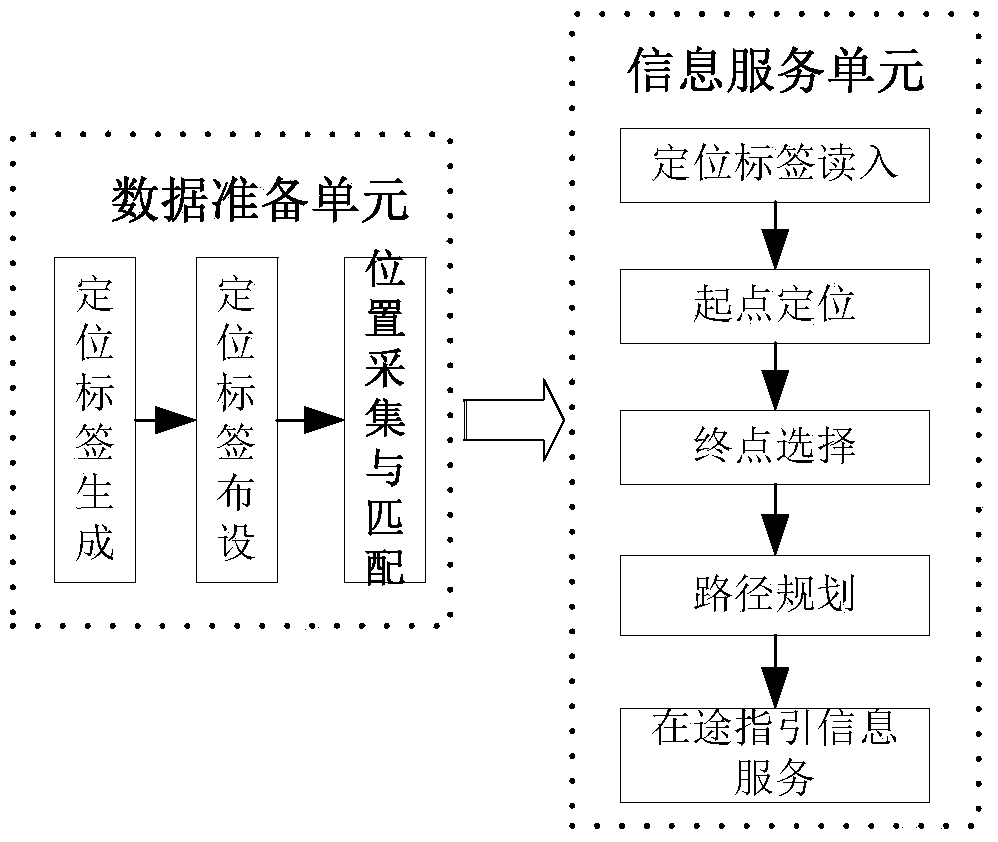
[0074] Such as figure 1 As shown, the implementation and application of the present invention are divided into two units: a data preparation unit and an information service unit. Among them, the data preparation unit mainly completes the generation and layout of the tags, the collection of the location of the tags in the real scene, and the matching with the electronic map. The information service unit, firstly, the traveler reads the label through a hand-held or vehicle-mounted smart device during the travel process to perform precise positioning; secondly, the traveler selects or reads the terminal information, and then the electronic map built in advance On this basis, travel route planning is carried out, and guidance information is provided during the travel process in the form of pictures, labels, etc., to ensure that travelers c...


PUM


Abstract

The invention provides a city complex traffic environment path guide system and method based on locating labels. The method comprises the steps: (101) locating labels of two-dimension codes or classification codes and the like are arranged on the peripheries and vital lines of complex road junctions, interchanges, comprehensive transportation junctions and commercial building clusters; (102) the locating labels of the two-dimension codes or the classification codes and the like are linked to the physical positions of the locating labels arranged in realistic scenes; (103) the locating labels in the realistic scenes are scanned through a handheld or vehicle-mounted terminal, so that locating or path planning based on locating is achieved. The step (101) further comprises the step (101-1) for generating the locating labels; the step (101-2) for constructing a traffic network topology of a city complex environment by the adoption of a three-dimensional model capable of distinguishing nodes; and the step (101-3) of distributing different weighted values to different road sections, then obtaining an optimal edge dominating set based on the obtained network topology and the road section weighted values, and arranging the locating labels for the optimal edge dominating set.

Description

technical field [0001] The present invention relates to an urban traffic information service system and method, in particular to a positioning tag-based route guidance service system and method for urban complex traffic environments. Background technique [0002] With the rapid development of the city, there are more and more complex urban traffic environments such as complex intersections, interchanges, comprehensive transportation hubs, and commercial building groups, which have caused great problems for the public to travel. The demand for information services is getting stronger and stronger. The main problems of route guidance information services in urban complex traffic environments are: first, the location of travelers is difficult to locate accurately, and second, the problem of route guidance from the start point to the end point. [0003] In order to solve the above problems, the general approach is to use smart handheld terminals and satellite positioning techno...

Claims


Application Information

Patent Timeline
Patent Type & Authority Applications(China)
IPC IPC(8): G08G1/0969G08G1/137G06K7/10G06K7/00
Inventor 王振华雷利军单雅文景泽涛王法岩聂炜翟羽佳荆长林田启华
Owner CHINA AEROSPACE SYST ENG
Why Eureka
Try Eureka